North Carolina High Country Braces for 10+ Inches of Snow While Light Wrap-Around Flurries Eye Northeast NC and Southern Virginia
NORTH CAROLINA — Snow is intensifying across the higher elevations of the North Carolina mountains this afternoon, especially in the High Country, where accumulating snowfall is expected to continue through Monday morning and could exceed 10 inches on some ridge tops.
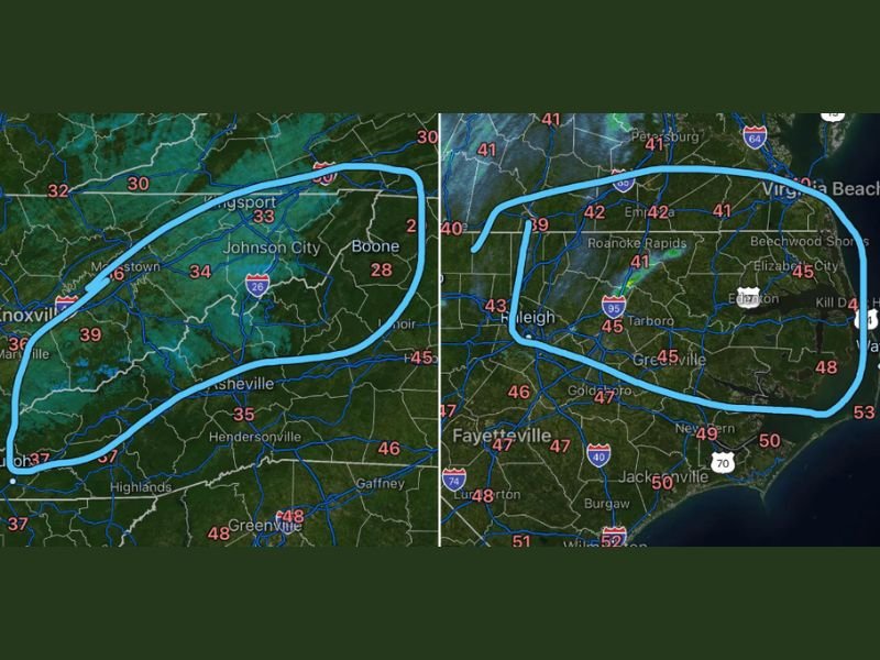
As of early afternoon, forecasters report that snow has “started cranking” across mountain communities, with the heaviest bands focused near Boone and surrounding high elevations.
Heavy Snow Targeting Boone and the High Country
Temperatures across the mountain region are cold enough to support steady accumulation:
- Boone: 28°F
- Johnson City: 33°F
- Kingsport: 33°F
- Asheville: 35°F
Several inches of snow are expected in the High Country, with the highest peaks and ridge tops potentially seeing 10 inches or more by the time the system winds down Monday morning.
Blowing snow and hazardous travel conditions are likely, particularly on exposed roadways and higher-elevation routes. Drivers heading toward mountain communities should prepare for rapidly changing visibility and snow-covered roads.
Forecasters indicate that the current forecast remains on track, with no major changes from earlier projections.
Wrap-Around Moisture Could Bring Light Snow to Northeast NC
While much of the rest of the state has seen radar activity quiet down, attention now turns to potential wrap-around moisture later this afternoon and evening.
The area of concern includes locations northeast of the Triangle, extending toward the Virginia border and into portions of Southern Virginia.
Temperatures in the region include:
- Raleigh: 43°F
- Roanoke Rapids: 42°F
- Emporia, VA: 42°F
- Tarboro: 45°F
- Elizabeth City: 45°F
- Virginia Beach: Near 41°F
Although little to no accumulation is expected in most of these lower-elevation areas, forecasters cannot rule out light snow showers or brief light accumulation on grassy or elevated surfaces, particularly across northeastern North Carolina and into Southern Virginia late this evening.
Road impacts in these eastern areas are expected to be minimal, but brief bursts of snow could create slick spots if heavier showers develop.
What to Expect Through Monday Morning
Mountain snowfall will remain the primary impact zone through Monday morning, with:
- Several inches common in the High Country
- Double-digit totals possible on ridge tops
- Blowing snow and reduced visibility
- Hazardous travel at higher elevations
Elsewhere across North Carolina, the focus remains on isolated, light wrap-around snow showers with minimal accumulation. Residents traveling into the mountains should monitor updated road conditions and be prepared for winter driving conditions.
For continued updates on this developing winter weather event across North Carolina, stay connected with CabarrusWeekly.com for the latest forecast information and local impact coverage.