North Carolina Snowfall Totals Reveal Above-Average Winter in Asheville, Boone, Charlotte and Wilmington While Raleigh Sees Major Snow Deficit
NORTH CAROLINA — The 2025–2026 winter season has officially come to an end, and snowfall data across the state shows a clear pattern: most regions saw above-average totals, while the Raleigh area experienced a notable shortfall.
Mountains and Western North Carolina Lead in Snowfall Totals
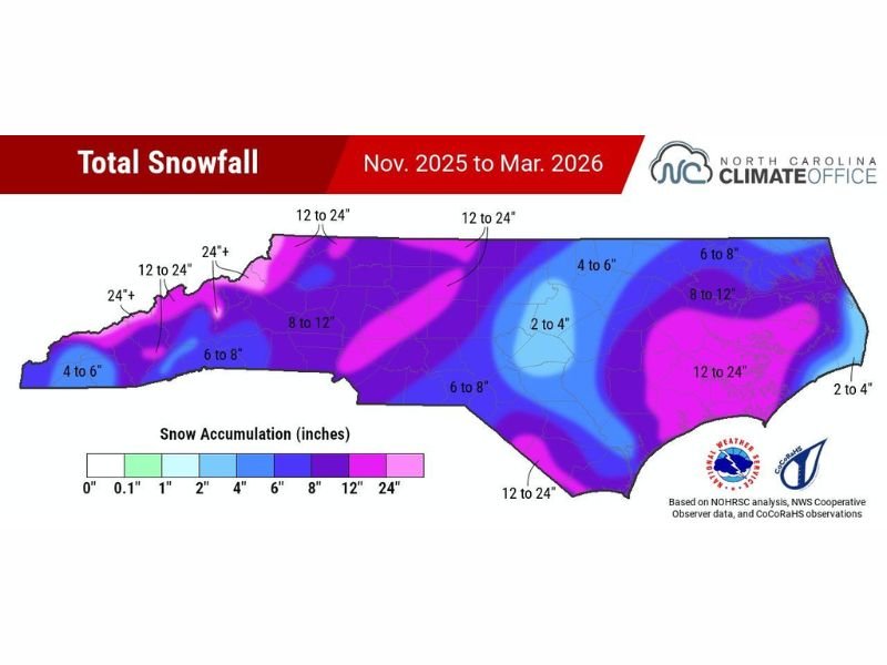
Snowfall was most impressive across the higher elevations of western North Carolina, including areas around Asheville, Boone, and the surrounding mountain communities, where totals ranged from 12 to over 24 inches.
Some localized spots even exceeded 24 inches, highlighting a strong winter season in the mountains. These totals are well above normal and reflect consistent storm activity throughout the season.
Foothills and Central Regions See Solid Winter Snow
Moving east into the foothills and central parts of the state, snowfall totals generally ranged between 6 to 12 inches, with some areas reaching up to 12 to 24 inches in localized bands. Cities such as Charlotte, Hickory, and Greensboro experienced a fairly active winter, with snowfall events spread across multiple systems rather than a single major storm.
Raleigh Area Stands Out with Snowfall Deficit
One of the most noticeable features on the statewide snowfall map is a clear “hole” centered around Raleigh, where totals dropped significantly compared to surrounding areas.
Much of the Raleigh region recorded only 2 to 4 inches of snow, which is well below what neighboring regions received. This sharp contrast suggests that storm tracks frequently missed the area or brought mixed precipitation instead of accumulating snow.
Eastern North Carolina Sees Mixed Results
Across eastern North Carolina, snowfall totals varied widely. Coastal areas, including Wilmington and the Outer Banks, generally saw lighter amounts in the 2 to 4 inch range, which is typical given their proximity to warmer ocean air.
However, parts of eastern inland regions experienced higher totals between 6 and 12 inches, and even localized areas reaching 12 to 24 inches, indicating stronger storm impacts farther inland.
What This Winter Pattern Tells Us
The distribution of snowfall across North Carolina highlights how small shifts in storm tracks can dramatically change outcomes. While most of the state benefited from favorable conditions for snow, Raleigh consistently fell on the less favorable side of these systems. This winter reinforces how regional variability plays a major role in snowfall totals, even within the same state.
Looking Ahead After an Active Winter
With winter now over, attention turns to the upcoming spring season, where changing weather patterns will bring warmer temperatures and increased variability.
As referenced in the seasonal data summary , this winter’s snowfall distribution provides valuable insight into storm behavior and regional climate trends across North Carolina. Stay with CabarrusWeekly.com for continued seasonal coverage, and share how much snow your area received during this past winter.