North Carolina, South Carolina, Georgia and Texas Brace for Early April Heat Surge as 90°F Becomes Possible Next Week
UNITED STATES — After a brief stretch of cooler and more comfortable conditions, a significant warm-up is now building across large parts of the country, with the South, Southeast, and parts of the East expected to surge well above normal temperatures between April 11 and April 15.
Forecast data shows widespread above-average temperatures dominating the eastern half of the U.S., with the strongest signals centered over Texas, the Deep South, and the Southeast including North Carolina, South Carolina, and Georgia.
Strong Signal for Above-Normal Temperatures Across the South and East
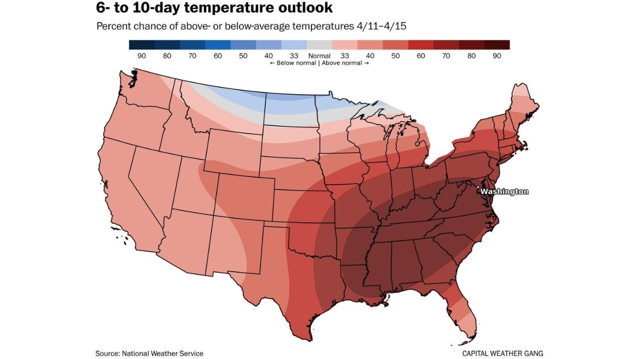
The latest 6- to 10-day outlook highlights a deep red zone across much of the eastern United States, indicating:
- High confidence in above-normal temperatures
- A broad area stretching from Texas through the Southeast and into the Mid-Atlantic
- Continued warmth extending into parts of the Northeast
States most impacted include:
- Texas
- Louisiana, Mississippi, Alabama
- Georgia, South Carolina, North Carolina
- Tennessee and parts of the Ohio Valley
- Virginia and surrounding Mid-Atlantic areas
This pattern signals a major shift back to warmth following the recent cooler air mass.
How Warm Could It Get
Forecast trends suggest temperatures could climb significantly:
- Highs reaching the upper 80s across much of the South
- 90°F becoming possible in parts of Texas and the Southeast
- Potential for near-record or record-challenging temperatures in some locations
This would mark one of the first widespread early-season heat events of April, especially notable given how early in the month it is.
Short Cool Break Before the Heat Returns
The current cooler conditions are expected to be short-lived, lasting only a few days before the warm pattern takes over.
This means:
- A rapid temperature rebound heading into early next week
- A noticeable shift from cool spring mornings to much warmer afternoons
- Increasing potential for summer-like warmth in some regions
Why This Warm Pattern Is Developing
The setup is driven by a large-scale atmospheric pattern favoring warmth across the eastern U.S., including:
- A persistent ridge of high pressure over the South and Southeast
- Warmer air being transported northward from the Gulf region
- Limited cold air intrusions during this period
This pattern supports stable, dry, and increasingly warm conditions across a wide area.
April Trending Warmer Than Normal Overall
Beyond just this short-term heat surge, the broader trend suggests:
- April is shaping up to be a warmer-than-normal month overall
- Repeated warm-ups may occur throughout the month
- The pace of warming is consistent with recent trends
This aligns with the ongoing pattern of above-average temperatures dominating much of the U.S. in early 2026.
What This Means for the Southeast and Mid-Atlantic
For areas like North Carolina, South Carolina, Georgia, and Virginia, this upcoming warm stretch could bring:
- Ideal outdoor conditions initially
- Increasing heat during the afternoons
- A transition toward more summer-like weather patterns earlier than usual
Residents should be prepared for quick changes in temperature over a short period.
Stay With Cabarrus Weekly for Continued Weather Coverage
As this warming trend develops and evolves, additional updates will provide more detail on temperature records, regional impacts, and any accompanying weather changes.
Stay with Cabarrus Weekly for the latest insights as early April heat builds across the United States.