North Carolina, South Carolina, Georgia, Tennessee, Alabama, and Virginia Wake Up to Winter-Like Chill as Spring Cold Snap Grips the Southeast
NORTH CAROLINA — A sharp and unexpected cold snap is sweeping across the Southeast, bringing winter-like temperatures back into North Carolina, South Carolina, Georgia, Tennessee, Alabama, and Virginia, despite the official arrival of spring.
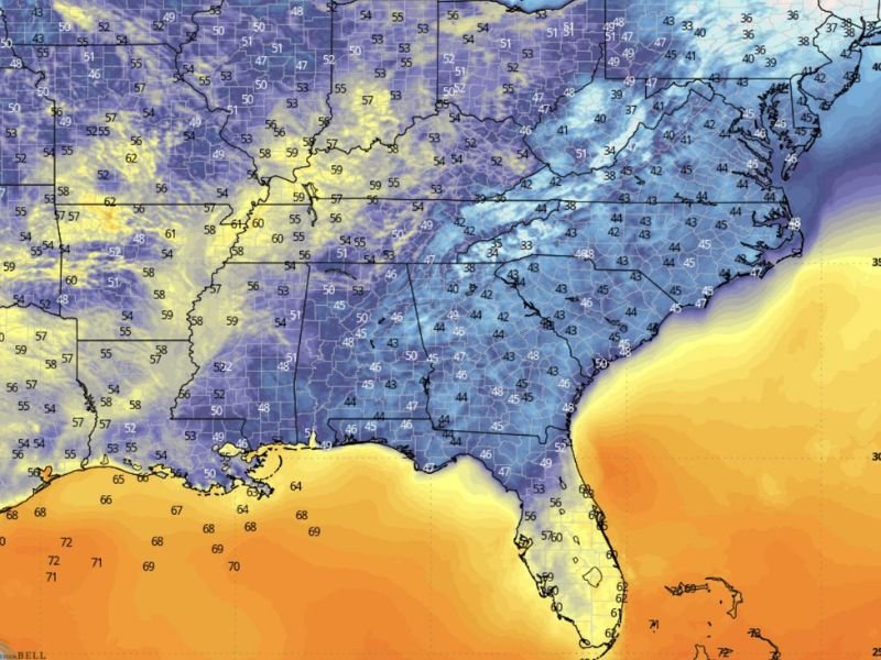
Cold Air Dominates the Southeast Region
Temperature data shows a widespread area of 40s and low 50s stretching across much of the Southeast, with even colder pockets dipping into the 30s across parts of Tennessee, western North Carolina, and Virginia.
This surge of chilly air is being driven by a reinforcing push of cooler air from the north, preventing any meaningful warm-up. Areas that typically expect mild spring mornings are instead dealing with conditions more typical of late winter.
Morning Chill Feels Like Winter Again
Early morning conditions across the region have been particularly harsh for mid-March standards. Cities across North Carolina and South Carolina are waking up to temperatures in the low to mid-40s, while inland areas and higher elevations are seeing even colder readings.
The contrast is especially noticeable given the recent warm spells. Many residents expecting a typical spring morning instead encountered cold air that feels sharp, dry, and uncomfortable, especially during early commutes.
Gulf Coast and Florida Stay Warmer
While much of the Southeast is locked in this cold pattern, areas closer to the Gulf Coast and Florida are seeing significantly warmer conditions, with temperatures rising into the 60s and even low 70s.
This sharp temperature gradient highlights just how strong the cold air mass is across inland states. The dividing line between chilly and mild air is clearly defined, with southern Florida largely escaping the cold snap entirely.
Why This Spring Cold Snap Is So Noticeable
The timing of this cold surge is what makes it stand out. Coming right at the start of spring, it creates a dramatic mismatch between seasonal expectations and actual conditions.
Afternoon temperatures may moderate slightly into the 50s for many areas, but the lingering chill in the air—combined with cloud cover and occasional breezes—keeps it feeling much colder than typical spring standards.
This pattern is often referred to as a “false spring” reset, where early warmth is quickly replaced by another round of cold air before sustained spring conditions fully arrive.
What to Expect Over the Next 24 Hours
The cold air mass is expected to remain in place through the day, with only gradual improvement. High temperatures across North Carolina, South Carolina, and Georgia will likely stay below average, struggling to climb much beyond the 50s in many locations.
Overnight into the next morning, temperatures could once again dip into the upper 30s and low 40s, especially in inland and rural areas. This may lead to another chilly start before a slow warming trend begins later in the week.
Final Outlook
This early spring cold snap is a reminder that seasonal transitions can be unpredictable, especially across the Southeast. With below-normal temperatures dominating multiple states, residents should be prepared for at least another day of cooler-than-expected weather.
Layered clothing and caution during early morning hours will be important as the region waits for a more consistent spring pattern to take hold.
Stay connected with CabarrusWeekly.com for the latest weather updates, and share how this sudden chill is impacting your area.