North Carolina, South Carolina, Virginia, Maryland, Pennsylvania and Washington DC in Path of Dangerous Two-Day Severe Weather Outbreak With Tornadoes and Damaging Winds
UNITED STATES — A powerful two-day severe weather outbreak is expected to impact large portions of the Mid-South, Southeast, and Mid-Atlantic, with storms capable of producing damaging winds, tornadoes, and large hail from the Mississippi Valley to the East Coast.
The developing storm system is tied to a major weather pattern already producing a blizzard in the Upper Midwest, while the southern and eastern sides of the system generate widespread severe thunderstorms.
Millions of people across multiple states could experience travel disruptions, damaging storms, and rapidly changing weather conditions from Sunday through Monday.
Severe Storms Spread From Mississippi Valley Into the Southeast Sunday
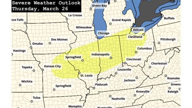
The first phase of the outbreak develops Sunday across the Mississippi Valley and parts of the Tennessee and Ohio Valleys.
Storm outlook maps show a broad zone of severe weather risk covering states including Arkansas, Mississippi, Tennessee, Kentucky, Illinois, Indiana, and Alabama, with the strongest storms expected from Little Rock and Memphis through Nashville and Louisville.
The main concern during this stage of the storm system is widespread damaging winds produced by a large squall line moving eastward.
Embedded tornadoes may also develop within the line of storms, particularly across portions of the Mid-South and Tennessee Valley.
Damaging Winds Expected to Be the Most Widespread Hazard
Wind outlook maps highlight a corridor of higher wind probabilities stretching from Mississippi and Tennessee northward through Kentucky and into Indiana and southern Illinois.
In this region, storms may produce powerful straight-line wind gusts capable of downing trees and power lines, leading to localized structural damage and scattered power outages.
Because the storms are expected to organize into a fast-moving line, damaging winds may affect large areas as the system pushes east through the evening and overnight hours.
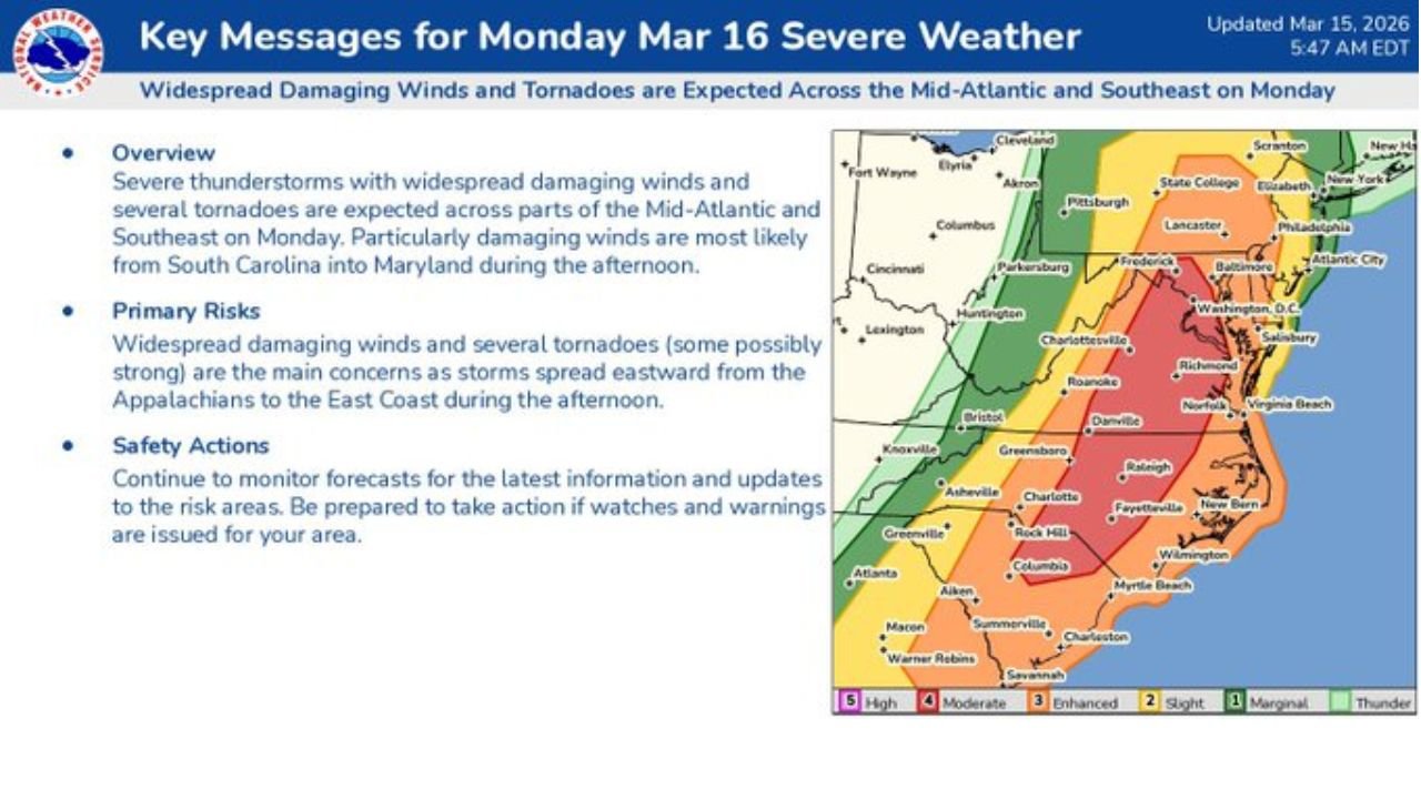
Tornado Risk Increases As Storm System Moves East
Tornado probability maps show the risk expanding eastward into parts of the Southeast and Mid-Atlantic by Monday.
The corridor of higher tornado potential stretches from South Carolina and North Carolina north through Virginia, Maryland, and into southeastern Pennsylvania.
Cities within this region include Charlotte, Raleigh, Greensboro, Richmond, Norfolk, Baltimore, and Washington DC, all of which fall within areas where severe storms could intensify.
Some of these storms may produce fast-moving or long-track tornadoes as the system tracks north along the East Coast.
Large Population Centers Within the Severe Weather Corridor
Several major metropolitan areas fall within the broader severe weather risk zone during the two-day event.
Cities listed within the potential impact area include:
- Jacksonville, Florida
- Charlotte, Raleigh, and Durham, North Carolina
- Richmond and Virginia Beach, Virginia
- Baltimore, Maryland
- Washington DC
- Philadelphia, Pennsylvania
With millions of residents located along this corridor, the storm system could create widespread disruptions to travel, power infrastructure, and daily activities.
Severe Storms Expected Through Overnight and Into Monday
Storms developing Sunday are expected to continue through the overnight hours before intensifying again Monday as the system moves toward the East Coast.
On Monday, severe thunderstorms with damaging winds and tornado potential are expected across the Carolinas and Mid-Atlantic, particularly from South Carolina into North Carolina, Virginia, and Maryland.
As the storms move north, additional impacts may spread toward Pennsylvania and surrounding regions later in the event.
Multi-Hazard Event Spanning Several Regions
The overall storm system is producing multiple hazardous weather conditions across the United States simultaneously.
While the Upper Midwest faces blizzard conditions, areas farther south and east are dealing with severe thunderstorms capable of producing tornadoes, damaging winds, and hail.
Because the storm system covers a wide geographic area and unfolds over multiple days, communities across the central and eastern United States could experience rapidly evolving weather conditions.
Stay with CabarrusWeekly.com for continued coverage and updates as this major severe weather outbreak develops across the Southeast and Mid-Atlantic.