North Carolina, Virginia and Pennsylvania in Early Icing Signal as Multiple Models Show Freezing Rain Just North of Key Thermal Boundary
NORTH CAROLINA — A developing weather setup for early next week is drawing attention from forecasters across the Mid-Atlantic and Northeast, as multiple forecast models are now showing a notable freezing rain signal just north of a critical thermal boundary.
While it remains too early for specific impact forecasts, the agreement across several major models is raising awareness.
Where The Icing Signal Is Strongest
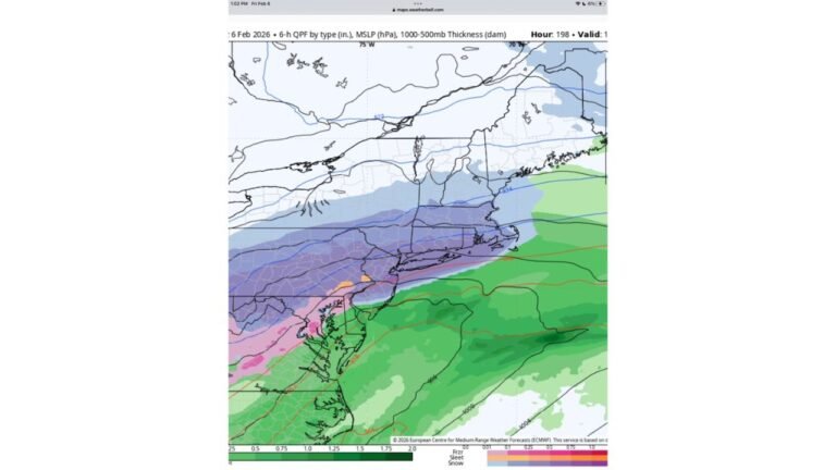
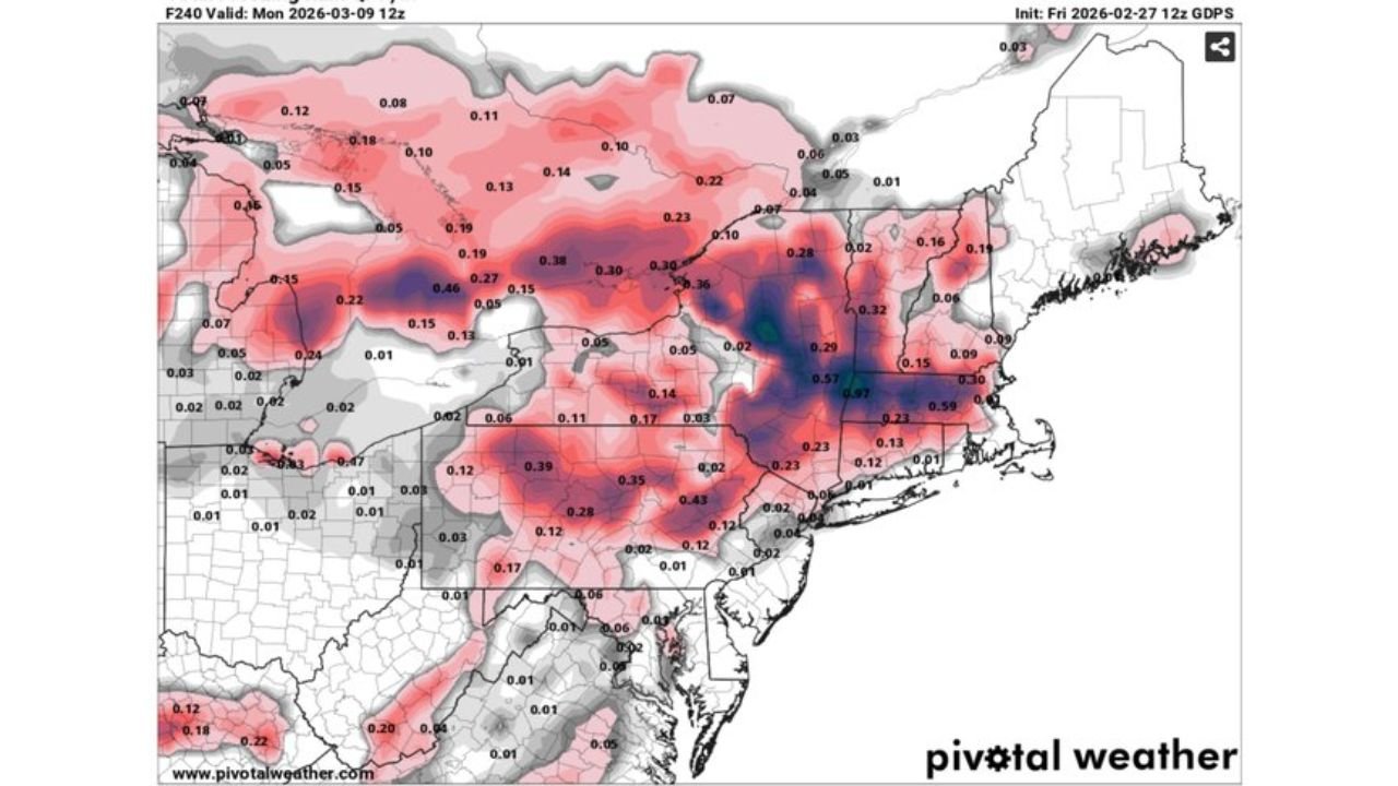
Freezing rain QPF (quantitative precipitation forecast) maps from:
• ECMWF (European model)
• GFS (American model)
• GDPS (Canadian model)
show the highest ice accumulations concentrated across:
• Central and eastern Pennsylvania
• Northern Maryland
• Northern and western Virginia
• Parts of West Virginia
• Interior New Jersey and southern New York
Some model runs depict pockets exceeding one-quarter inch of freezing rain in portions of Pennsylvania and northern Maryland — a level that can cause tree damage and power outages if it verifies.
The Thermal Boundary Setup
The risk appears to hinge on a sharp north-south temperature gradient, often referred to as a thermal boundary.
South of the boundary:
• Mainly rain
• Surface temperatures above freezing
North of the boundary:
• Sub-freezing surface temperatures
• Warm air aloft
• Classic freezing rain profile
Even small shifts in this boundary could dramatically alter who sees icing versus cold rain.
What This Means for North Carolina
For North Carolina, especially central and southern areas including Cabarrus County:
• Current projections keep the primary icing threat north of the state
• Most areas would see rain if the boundary remains north
• However, northern North Carolina could be close enough to monitor closely
If colder air presses farther south than currently forecast, the risk zone could shift.
Why Forecasters Are Watching Closely
The concern is not necessarily certainty — it’s the signal strength at this lead time.
When multiple global models consistently show:
• 0.10 to 0.30 inches of freezing rain
• A defined corridor of icing potential
• A sharp temperature contrast
it warrants attention even several days out.
Still, exact placement will depend on:
• Storm track
• Cold air supply at the surface
• Timing of precipitation onset
Too Early for Specific Impacts
Forecasters emphasize that this is not yet a finalized winter storm forecast.
At this stage:
• Individual town-by-town solutions are premature
• Thermal boundary placement could shift 50–100 miles
• Accumulation forecasts will change with new data
But the pattern is clearly one that favors icing just north of the rain-snow dividing line.
Bottom Line
A notable freezing rain signal is emerging for portions of Pennsylvania, Virginia, Maryland and nearby states early next week, driven by a sharp temperature boundary.
North Carolina currently sits near the southern edge of that setup, meaning rain is more likely locally — but the situation bears watching if colder air trends south.
Cabarrus Weekly will continue tracking updated model guidance and provide local impact assessments as the forecast becomes clearer.