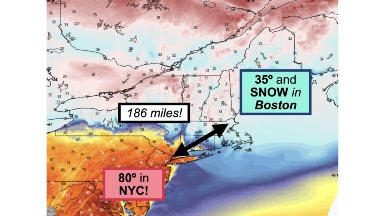
North Carolina, Virginia, Maryland and Mid-Atlantic Surge 15 to 25 Degrees Above Normal Sunday With Highs Near 80 Degrees
NORTH CAROLINA — A brief but notable surge of early spring warmth is set to arrive Sunday, pushing temperatures well above normal across the Carolinas and the broader Mid-Atlantic.
Temperatures Climb Toward 80 Degrees Across the Region
Forecast data shows afternoon highs rising toward the upper 70s and near 80°F across North Carolina, Virginia, and parts of Maryland, marking one of the warmest days so far this season.
This warming trend follows a relatively comfortable Saturday, but conditions will quickly shift as a stronger warm air mass moves into the region.
For many locations, this will feel like a sudden jump into late spring rather than late March.
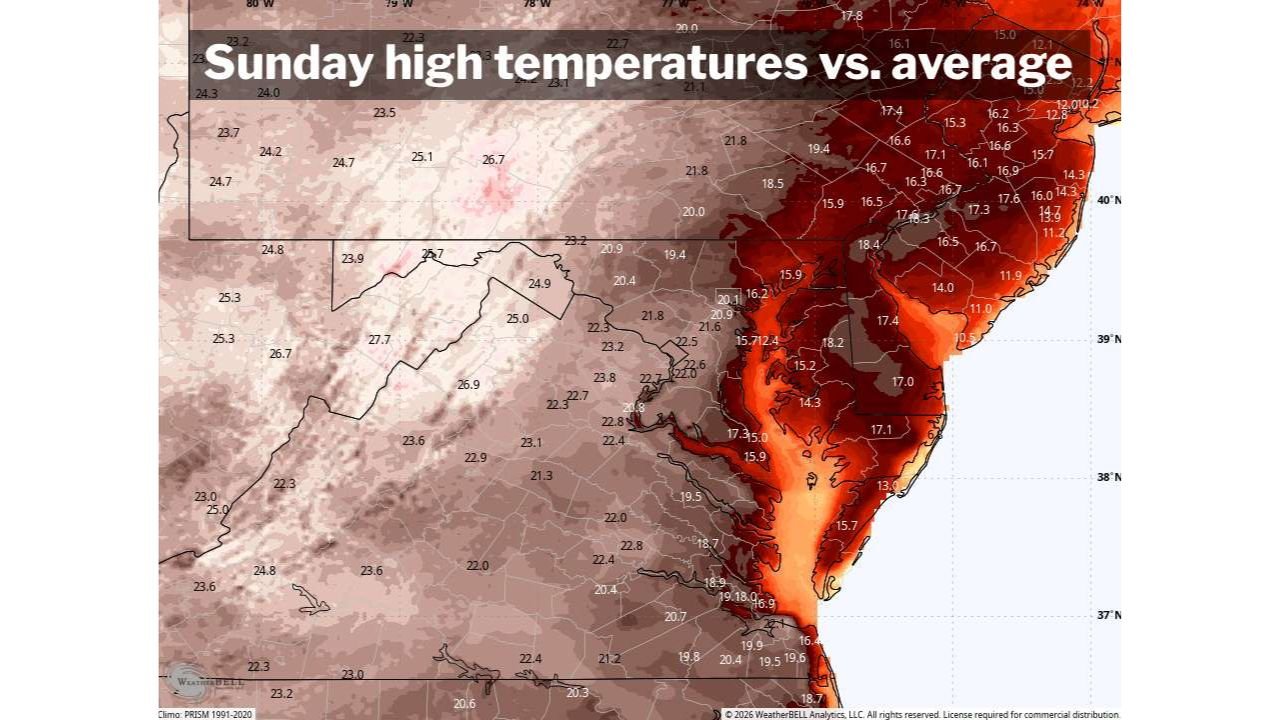
15 to 25 Degrees Above Normal for Late March
Temperature anomaly data indicates much of the region will run 15 to 25 degrees above average, with the strongest departures seen across Virginia, Maryland, Delaware, and southern Pennsylvania.
The coastal Mid-Atlantic, including areas near the Chesapeake Bay, shows some of the most intense anomalies, where warmth is amplified by favorable wind patterns and sunshine.
Even inland areas across the Carolinas will experience significant departures from seasonal norms, reinforcing how unusual this warm spell is for March.
Strongest Warmth Focused Across the Mid-Atlantic Corridor
The core of the warm anomaly stretches from North Carolina northward through Virginia, Washington D.C., Maryland, and into southern New Jersey and Pennsylvania.
This corridor will experience the most consistent and widespread warmth, with many areas firmly in the mid to upper 70s, and some spots briefly touching 80°F.
Further west, temperatures remain warm but slightly less extreme, highlighting a gradient in the intensity of the heat.
Brief Warm Spell Before Changing Conditions
Despite the impressive warmth, this pattern is expected to be short-lived, as changes in the larger weather setup bring the potential for increasing clouds and even evening showers.
This suggests that while Sunday will deliver peak warmth, conditions may begin to shift afterward, preventing a prolonged heat event in the region.
What This Means for North Carolina
For North Carolina, this surge represents a quick taste of early-season heat, with conditions favorable for outdoor activity but also notable for how far above normal temperatures will climb.
Residents can expect pleasant but unusually warm conditions during the afternoon, followed by the possibility of changing weather later in the day.
This type of rapid warm-up can also trigger early blooming and seasonal transitions, especially after a relatively mild start to spring.
Stay with CabarrusWeekly.com for continued updates on this developing weather pattern. If you’re noticing the sudden warm-up in your area, share your experience with the CabarrusWeekly.com community.