North Carolina, Virginia, Maryland and Washington DC Face Moderate Risk for Severe Storms Monday With Tornadoes, 75+ MPH Winds and Large Hail Possible
NORTH CAROLINA — A powerful severe weather setup is expected to impact parts of the Southeast and Mid-Atlantic on Monday, March 16, 2026, with central and eastern North Carolina placed under a Level 4 Moderate Risk for severe storms. The storm system could bring tornadoes, widespread damaging wind gusts above 75 mph, and large hail as it moves through the region during the afternoon and evening hours.
The highest risk area includes central North Carolina and nearby parts of southeastern Virginia, while severe weather threats may extend north toward Maryland and the Washington DC region later in the day.
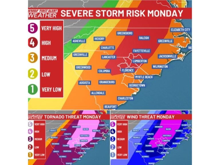
Central North Carolina in the Core of the Severe Weather Risk
Storm outlook maps show a Moderate Risk zone covering a large portion of central North Carolina, including cities such as Charlotte, Greensboro, Durham, Raleigh, Fayetteville, and Wilmington.
This category represents one of the higher levels on the severe weather outlook scale and indicates an increased likelihood of multiple severe storms capable of producing significant impacts.
The expected storm environment supports tornado development, damaging winds, and hail, with storms expected to organize into a line moving across the state during the afternoon and evening hours Monday.
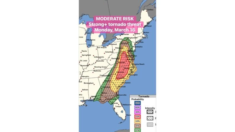
Tornado Potential Includes Possibility of Strong Tornadoes
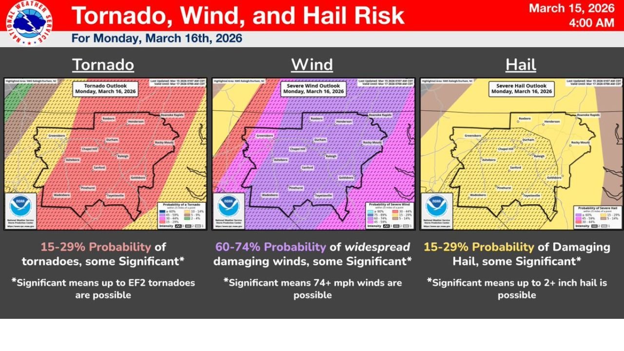
Storm probability maps indicate a 15% to 29% chance of tornado development within 25 miles of a location across parts of North Carolina, with the possibility that some tornadoes could reach EF2 strength.
The tornado risk is expected to be highest across central and eastern sections of the state, including areas near Raleigh, Greenville, Fayetteville, and the coastal plain.
Some storms could form rotating supercells ahead of the main line of storms, which can increase the likelihood of tornado formation.
Widespread Damaging Winds Could Exceed 75 MPH
Along with tornado potential, damaging wind gusts are expected to be one of the most widespread hazards with this storm system.
Forecast probability maps show a 60% to 74% chance of widespread damaging winds, indicating a strong likelihood of severe wind impacts across central and eastern North Carolina.
Wind gusts exceeding 74 to 75 mph are possible in the strongest storms, which could lead to downed trees, structural damage, and scattered power outages.
Cities including Raleigh, Durham, Greensboro, and Charlotte fall within the area where damaging winds could occur as the storm line moves through the state.
Large Hail Also Possible With Stronger Storms
Severe thunderstorms may also produce large hail across parts of the region, with probability maps indicating a 15% to 29% chance of damaging hail.
The strongest storms could generate hail larger than two inches in diameter, which can damage vehicles, roofs, and outdoor property.
Hail risk is expected to be highest across central North Carolina and nearby parts of South Carolina and Virginia as storms intensify.
Storm Timing Points to Monday Afternoon and Evening
The severe weather event is expected to develop Monday afternoon and continue into the evening hours, as a line of storms moves east across North Carolina.
The system will likely progress from western parts of the state toward the coastal plain, with storms eventually moving offshore later Monday night.
As the system shifts north and east, impacts may spread into southeastern Virginia, Maryland, and the Washington DC metro area.
Multiple Severe Hazards Expected Across the Region
The developing storm system has the potential to produce several severe hazards at the same time, including:
- Tornadoes, including the possibility of stronger tornadoes
- Widespread damaging wind gusts above 75 mph
- Large hail capable of causing property damage
Because the storms are expected to move quickly and affect multiple states, communities across the region may experience rapidly changing conditions.
Residents across North Carolina, Virginia, Maryland, and Washington DC should continue monitoring weather conditions closely as the storm system approaches.
Stay with CabarrusWeekly.com for continuing updates as severe weather develops across North Carolina and the Mid-Atlantic on Monday.