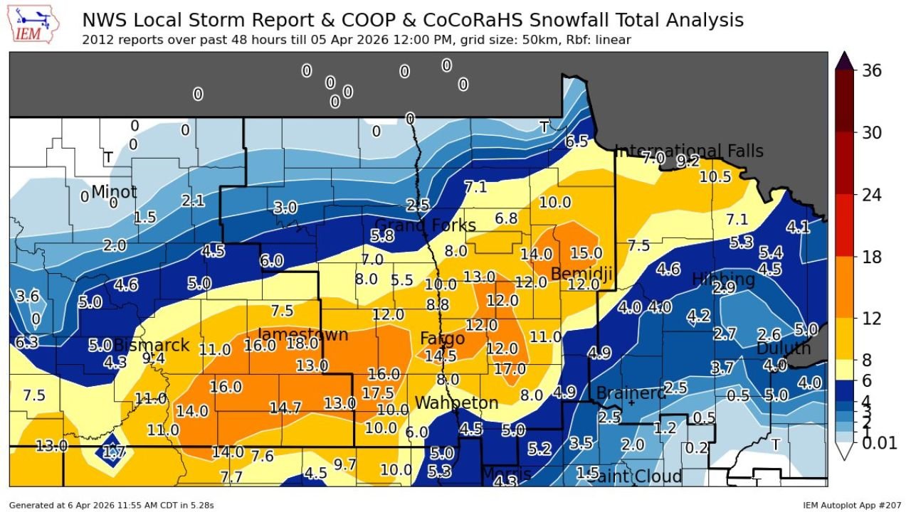
North Dakota and Minnesota Snowstorm Dumps Over 18 Inches Near Jamestown as Fargo and Bemidji See Double Digit Totals
NORTH DAKOTA AND MINNESOTA — A powerful late-season snowstorm delivered significant snowfall across parts of eastern North Dakota and northern Minnesota, with some areas recording over 18 inches of snow within a 48-hour period ending Sunday, April 5.
Compiled storm reports show a wide swath of heavy snow stretching from central North Dakota into northwest and north-central Minnesota, with sharp gradients in totals across relatively short distances.
Jamestown Area Hit Hardest With Near 18 Inches
The highest snowfall totals were concentrated around central and eastern North Dakota, especially near:
- Jamestown: up to 18.0 inches
- Surrounding areas: widespread 14 to 17+ inches
Nearby cities also saw substantial accumulation:
- Valley City and Wahpeton regions: around 16 to 17.5 inches
- Fargo: approximately 14 to 14.5 inches
This zone represents the core of the storm system, where consistent snowfall bands remained in place for extended periods.
Heavy Snow Extends Into Northern Minnesota
The storm continued into northern Minnesota with notable totals:
- Bemidji: around 14 to 15 inches
- Areas north toward International Falls: roughly 7 to 10.5 inches
While still significant, totals gradually decreased farther east and northeast compared to the North Dakota core.
Sharp Drop-Off Toward Duluth and Central Minnesota
Snowfall totals dropped quickly moving southeast:
- Brainerd: around 2 to 4 inches
- St. Cloud: near 1 to 2 inches or less
- Duluth: generally 2 to 5 inches, with localized variation
This sharp gradient highlights how storm track and band placement played a major role in determining totals, leaving some areas with far less accumulation.
Lighter Totals Across Northern North Dakota
Northern sections of North Dakota, including areas near:
- Minot
- Northern border regions
saw much lighter snowfall, generally:
- 0 to 3 inches, with some locations reporting minimal accumulation
This indicates the northern edge of the storm remained weaker, with the heaviest bands staying farther south.
What Made This Storm Significant
Several factors contributed to the high totals:
- Persistent snowfall bands over the same regions
- A well-defined storm track favoring central and eastern North Dakota
- Efficient accumulation over a 48-hour window, allowing totals to build steadily
The result was a classic late-season Plains snowstorm, with intense localized impacts despite it being early April.
Travel and Regional Impact
The heavy snowfall likely created:
- Difficult travel conditions, especially near Jamestown, Fargo, and Wahpeton
- Reduced visibility during peak snowfall periods
- Potential disruptions across road networks in the hardest-hit zones
Meanwhile, areas just outside the main band experienced far less impact, emphasizing the storm’s narrow corridor of heavy snow.
Stay With Cabarrus Weekly for National Weather Coverage
Cabarrus Weekly will continue tracking major weather events across the United States, from late-season snowstorms in the Plains to developing severe weather patterns later in April.
Stay with us for continued updates on storm impacts, forecasts, and evolving weather conditions nationwide.