North Texas Rain Event Could Deliver 1–2 Inches From Friday Night Through Saturday as Storms Target DFW With Higher Totals Toward Oklahoma and Arkansas
TEXAS — A long-awaited rain chance is shaping up across North Texas, with guidance pointing to a healthy storm complex arriving after 9 p.m. Friday night and continuing into Saturday, producing thunderstorms, gusty winds, lightning, and pockets of heavy rainfall across the Dallas–Fort Worth region and nearby areas.
Timing: Storms Build After 9 PM Friday, Continue Much of Saturday
The current timing window begins after 9 p.m. Friday, with stronger thunderstorms expected overnight. A second round of energy arrives Saturday alongside a cool front and wrap-around moisture, which is expected to keep rain chances going through most of Saturday.
The system is forecast to move out by midnight Saturday night, making this a roughly 24–30 hour stretch of off-and-on rainfall and storm chances for parts of the region.
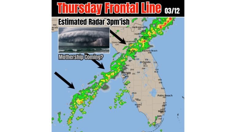
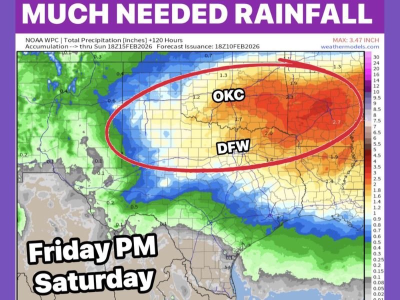
Main Impact Zone: DFW and North Texas Under the Core Rain Signal
The precipitation map highlights a broad corridor of heavier totals centered over North Texas, including the DFW Metroplex, with the heaviest shading expanding north and northeast. The coverage suggests this is not a narrow storm track, but a larger rain shield capable of delivering meaningful totals across multiple counties.
This matches the “best rain chances all winter” theme described in the update, with the best overlap of moisture and lift focused across North Texas.
Rain Totals: 1–2 Inches Likely, Higher North and Northeast
Overall rainfall totals are expected to land in the 1 to 2 inch range for many locations across North Texas. However, the outlook indicates higher totals in Oklahoma and also northeast of the Metroplex into Arkansas, where the deeper moisture and more persistent storm coverage may line up longer.
The map also supports that idea, showing the highest values concentrated north and northeast of DFW, including areas near Oklahoma City (OKC) and across parts of the Ark-La-Tex region.
Thunderstorms May Bring 50 MPH Gusts and Isolated Severe Potential East of Dallas
In addition to heavy rain, the update notes storms could produce gusty winds up to around 50 mph, along with frequent lightning and stronger downpours. There is also a mention that storms could turn severe east of Dallas Saturday afternoon or evening, suggesting the most favorable environment for stronger storms may shift east as the front progresses.
Even if widespread severe weather does not develop, wind bursts and brief stronger cells remain possible in the most active thunderstorm bands.
Why This Setup Lasts So Long
This is not a quick hitter. The extended duration comes from a storm complex followed by a secondary surge of energy, combined with cool frontal passage and wrap-around moisture. That combination can keep rain going longer, even after the main thunderstorm line passes.
CabarrusWeekly.com will continue monitoring significant weather patterns across the country, especially setups that signal shifting late-winter storm tracks and early-season thunderstorm potential. If you are in North Texas, Oklahoma, or Arkansas and see heavy rain or strong storms during this Friday night–Saturday window, share your rainfall totals and storm timing with CabarrusWeekly.com.