Northeast and Mid-Atlantic Including New York, Pennsylvania and North Carolina Set for Early April Warm Surge With 60s and 70s as Strong Ridge Builds
MID-ATLANTIC & NORTHEAST — A significant pattern shift is emerging for early April, with forecast models increasingly signaling a strong ridge building across the eastern United States, bringing widespread above-normal temperatures.
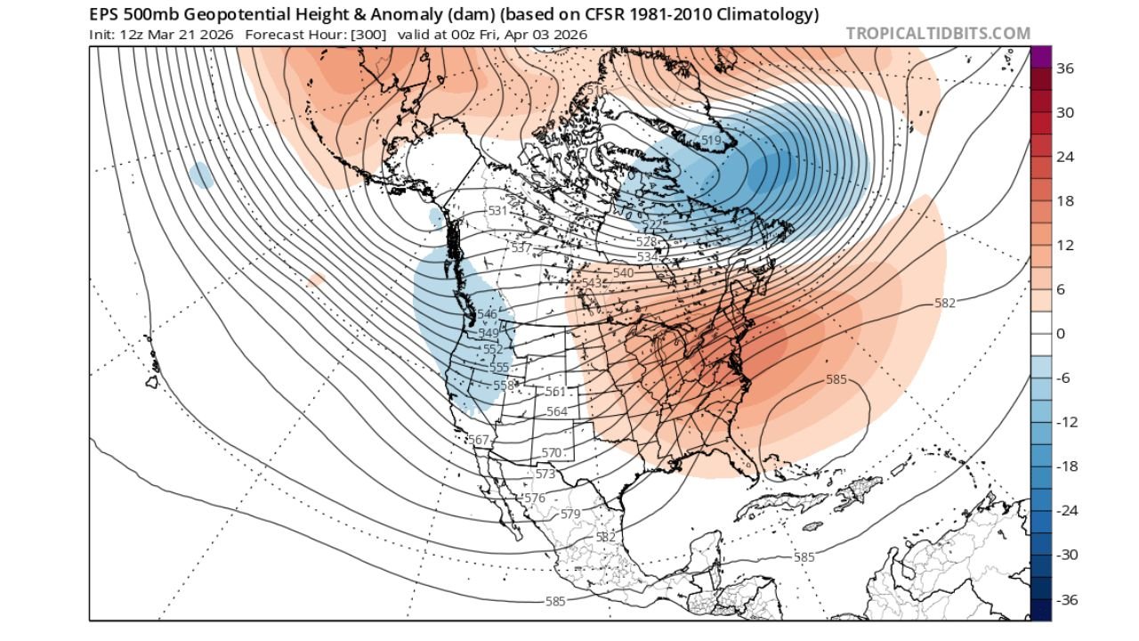
Strong Ridge Signals Major Warm Pattern Shift
Weather model ensembles are consistently showing a stout upper-level ridge developing over the Mid-Atlantic and Northeast, a setup that typically favors warmer and more stable conditions.
This ridge is expected to dominate the eastern half of the country during the first week of April, allowing milder air to expand northward and replace the recent swings between cold and warmth.
The presence of this ridge is a strong indicator that spring-like conditions are about to take hold in a more sustained way.
Temperatures Expected to Climb Into the 60s and 70s
As this pattern develops, temperatures across key states including New York, Pennsylvania, New Jersey, Maryland, Virginia, and North Carolina are expected to rise into the 60s and even 70s at times.
This represents a noticeable shift toward more comfortable and seasonable conditions, especially after recent volatile weather patterns.
Even typically cooler areas in the Northeast could see extended stretches of mild afternoons, signaling a clear transition into spring.
Why This Warm Pattern Is Developing
The warming trend is tied directly to the positioning of the jet stream, which is expected to shift northward as the ridge strengthens.
At the same time, cooler air remains locked across parts of Canada and the far northern Atlantic, helping to reinforce the contrast that supports the ridge over the eastern U.S.
This setup allows warmer air from the southern U.S. to flow northward, boosting temperatures across a wide region.
A More Stable Stretch of Weather
In addition to warmer temperatures, this pattern also suggests a period of relatively quieter weather, with fewer strong storm systems impacting the region.
While occasional systems may still pass through, the dominant ridge should limit widespread severe weather and promote more consistent day-to-day conditions.
What This Means for the Start of April
The first week of April is shaping up to feel much more like spring, with:
- Afternoon highs regularly in the 60s and 70s
- More sunshine and stable conditions
- A break from extreme temperature swings
This type of pattern often encourages early blooming and increased outdoor activity, though it’s still important to remember that occasional cold snaps can still occur in early spring.
Looking Ahead
While confidence is growing in this warmer pattern, long-range forecasts can still evolve. However, the consistency across multiple ensemble models adds confidence that the eastern U.S. is heading into a notably warmer stretch.
Residents across the Mid-Atlantic and Northeast should prepare for a welcome taste of spring, with milder days becoming more common as April begins.
Stay with CabarrusWeekly.com for the latest updates on shifting spring weather patterns across the United States.