Northeast, Mid-Atlantic, New England Face Sharp Temperature Divide as Cold Air Surges South Before Sunday Reversal
UNITED STATES — A sharp seasonal boundary is setting up across the Eastern U.S., creating a dramatic temperature contrast from New England down through the Mid-Atlantic and into the Southeast, as colder air pushes south before a quick reversal expected by Sunday.
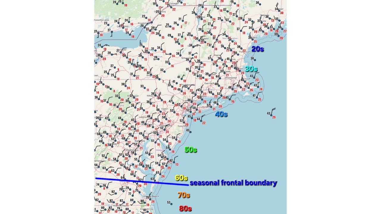
Cold Air Surging South Across the Northeast
A noticeable drop in temperatures is already underway across:
- New York, Vermont, New Hampshire, and Maine
- Interior portions of Pennsylvania and upstate regions
These areas are seeing temperatures fall into the:
- 20s across northern New England
- 30s through much of the interior Northeast
The colder air is filtering south behind a seasonal frontal boundary, bringing a much more winter-like feel compared to recent days.
Mid-Atlantic Caught in the Middle
Across the Mid-Atlantic, including:
- New Jersey, Delaware, Maryland, and parts of Virginia
temperatures are more mixed, generally ranging through the:
- 40s to low 50s
This places the region directly along the dividing line, where conditions can vary significantly over short distances, depending on how far south the cooler air pushes.
Warmth Holds Strong Across the South
South of the boundary, a completely different air mass remains in place across:
- Southern Virginia, North Carolina, and farther south into the Southeast
Temperatures here are still reaching:
- 60s, 70s, and even low 80s in some areas
This creates a striking contrast, where early spring warmth continues just a few hundred miles south of near-winter chill.
The Boundary Driving It All
At the center of this setup is a seasonal frontal boundary stretching across the Mid-Atlantic, separating:
- Cold, dense air to the north
- Warm, more humid air to the south
This type of boundary often becomes a focal point for shifting weather patterns and can move quickly depending on pressure changes.
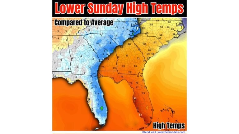
Sunday Brings a Rapid Reversal
By Sunday, the pattern begins to shift again as high pressure builds and pushes the colder air back northward.
This means:
- Temperatures will moderate across the Mid-Atlantic and Northeast
- The sharp contrast will begin to fade
- Warmer air will gradually reclaim areas that briefly cooled down
However, the transition may not be uniform, and some locations could still see lingering cool pockets early in the day before warming up.
What This Means for the Region
This setup highlights how quickly conditions can change during seasonal transitions:
- Northern areas experience a brief return to colder temperatures
- Mid-Atlantic regions see variable conditions depending on location
- Southern areas remain consistently warm and spring-like
Bottom Line
A temporary push of cold air is creating a sharp temperature divide across the Eastern U.S., with chilly conditions reaching deep into the Northeast and Mid-Atlantic. But the cooldown will be short-lived, as warmer air rebounds northward by Sunday, restoring a more typical early spring pattern.
Stay with CabarrusWeekly.com for continued updates as this shifting temperature pattern evolves.