Northeast States May See Late-Season Snow Chance as Blocking Pattern Forces Sharp Ensemble Shift Across New England, New York, and the Mid-Atlantic
UNITED STATES — Medium-range ensemble guidance has undergone a notable shift over the past several days, replacing an initially warm outlook with a much colder, block-driven pattern across the Northeast, New England, and parts of the Mid-Atlantic, raising questions about late-season snow potential heading into next weekend.
Ensembles Reverse From Warm Bias to Cold-Dominated Solution
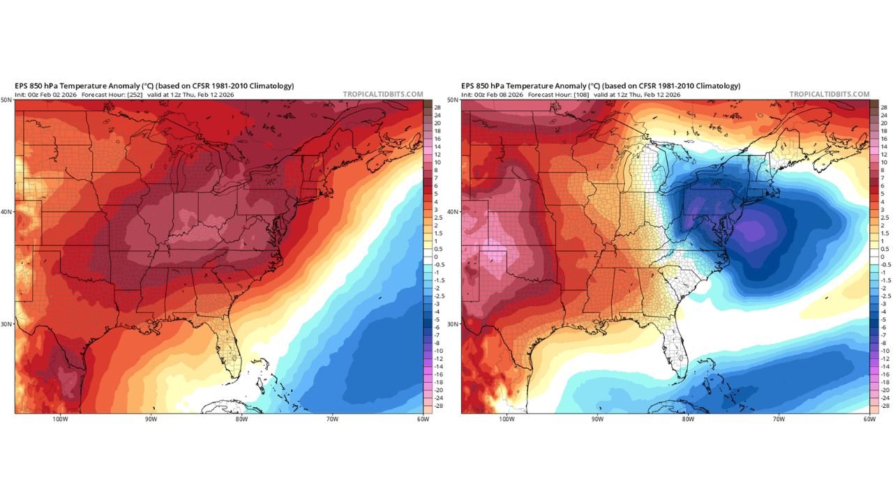
Earlier ensemble runs strongly favored above-normal temperatures across the eastern United States, including New York, Pennsylvania, New Jersey, and New England, suggesting a mild end to the week. However, the latest guidance now depicts a dramatically different thermal setup, with below-normal temperatures expanding southward from eastern Canada into the Northeast.
This type of reversal is typical when high-latitude blocking becomes dominant, a pattern that ensemble spread often struggles to resolve at longer lead times.
Blocking Pattern Forces Cold Air Southward
Current temperature anomaly maps show deep negative departures centered over New England and the western Atlantic, signaling a strong block that slows the jet stream and allows cold air to press southward. Meanwhile, warmer anomalies remain locked over the central Plains and Mississippi Valley, sharpening the thermal gradient along the East Coast.
Blocking patterns during February are historically efficient at overperforming cold and snow outcomes, particularly in Massachusetts, Vermont, New Hampshire, Maine, upstate New York, and northern Pennsylvania.
Why Ensembles Struggled With This Setup
Ensembles are designed to capture spread, but blocking regimes are notoriously underrepresented early, especially this time of year. The current evolution highlights how small upstream changes can lead to large downstream impacts, flipping temperature outcomes entirely.
As the block strengthens, the atmosphere becomes less progressive, increasing the chance that cold air remains entrenched long enough for precipitation systems to interact with it.
Late-Week and Weekend Snow Window Emerges
With colder air now favored, attention turns to late next week into the following weekend, when guidance suggests the possibility of snowfall on the backside of departing systems, particularly across New England and the interior Northeast.
At this range, exact timing and accumulation cannot be determined, but the pattern supports at least a credible snow signal, something that was largely absent in earlier runs.
What to Watch Going Forward
Confidence is increasing in the cold pattern itself, while confidence in specific snow events remains low but rising. If the blocking holds, even marginal systems could produce winter weather impacts in areas that had previously been expected to remain mild.
Residents across New England, New York, and the northern Mid-Atlantic should continue monitoring updates as higher-resolution guidance begins resolving details over the coming days.
If you’re seeing colder air arrive sooner or noticing changes in your local forecast, share your observations and stay connected with ongoing coverage at CabarrusWeekly.com.