Northern Edge of Coastal Storm May Deliver Overnight Snow “Thump” Around Philadelphia as Low Spins Off Mid-Atlantic Coast
NEW JERSEY — A developing coastal storm could deliver a brief but intense burst of snowfall around Philadelphia overnight Sunday into Monday morning, as the northern edge of the system brushes eastern Pennsylvania and parts of New Jersey.
Weather model guidance shows increasing odds that the storm’s precipitation shield expands far enough north to produce what meteorologists often call a snow “thump” — a short period of moderate to heavy snowfall capable of quick accumulations.
Coastal Low Strengthening Off the Mid-Atlantic
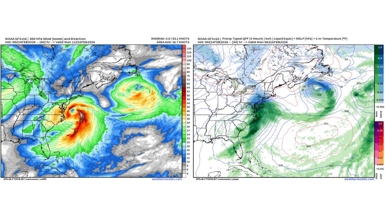
Forecast imagery shows a strengthening surface low developing near the Mid-Atlantic coastline before tracking offshore. As the storm intensifies, bands of precipitation wrap northwestward toward the Interstate 95 corridor.
The heaviest precipitation remains focused offshore and along coastal sections of the Mid-Atlantic. However, the northern edge of the storm’s precipitation shield appears close enough to potentially clip the Philadelphia metro.
This setup creates a narrow margin between limited impact and a more noticeable overnight snowfall.
Philadelphia Near the Critical Rain-Snow Line
Model projections indicate temperatures hovering near the freezing mark, particularly north and west of central Philadelphia.
If colder air holds in place while the precipitation shield expands, a quick burst of snow could develop late Sunday night. This scenario would favor:
Interior eastern Pennsylvania
Portions of northern and central New Jersey
Areas just northwest of downtown Philadelphia
Farther south and closer to the immediate coastline, warmer air could limit accumulation or keep precipitation mixed.
Narrow Window for Accumulation
Any accumulating snowfall would likely occur during a relatively short window — late Sunday night into early Monday morning.
Because this is a northern-edge scenario, small shifts in the storm track will dramatically change snowfall outcomes. A slight jog offshore would reduce impacts, while a minor northwest shift could bring steadier snow into more of the metro region.
Heaviest Impacts Likely South and Offshore
The core of the storm — including strongest winds and heaviest precipitation — remains centered over the western Atlantic and coastal Mid-Atlantic waters.
While inland areas like Philadelphia sit near the edge of the main snow shield, locations farther south along the Mid-Atlantic coast appear more directly within the heavier precipitation band.
For now, confidence remains moderate that at least a brief snowfall burst is possible around Philadelphia, but totals will depend heavily on exact storm positioning and temperature profiles.
Residents in eastern Pennsylvania and nearby New Jersey should monitor updated forecasts through Sunday evening.
If snow begins falling overnight in your area, share your conditions and photos with us at CabarrusWeekly.com as we track this evolving coastal storm.