Northern Utah Mountains Near 100% of Normal Precipitation While Salt Lake City, Ogden and Provo Show Mixed Water Year Totals
NORTHERN UTAH — A closer look at water year precipitation totals across Utah reveals a surprisingly balanced picture heading into early March, with most mountain observation sites in northern Utah sitting near seasonal averages.
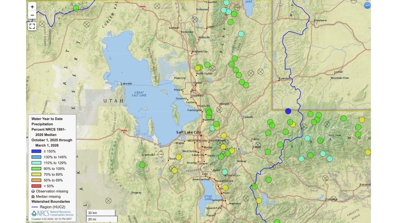
Data covering October 1, 2025 through March 1, 2026 shows that many high-elevation sites are reporting around 100% of the 1991–2020 median precipitation, suggesting the region’s snowpack and moisture levels are generally on track for this point in the season.
Mountain Sites Near Normal Across Northern Utah
Observation points in the mountains east of Salt Lake City, Ogden, Logan and Provo are largely clustered in the 90%–109% of normal range. Several sites even exceed 110%, indicating slightly above-average precipitation in parts of the Wasatch Range.
Key regions showing near-normal totals include:
- The Wasatch Mountains east of Ogden and Salt Lake City
- Mountain zones near Logan and the Bear River Range
- Higher terrain surrounding Provo and Utah Lake
The overall takeaway: northern Utah’s mountain precipitation mean is hovering around 100% of normal — a steady and stable water year so far.
Valley Totals More Mixed Around Salt Lake City and Provo
Lower-elevation sites tell a more varied story.
In the Salt Lake Valley, as well as areas near West Jordan, Sandy, Draper and Murray, precipitation totals range from slightly below normal (70%–89%) to near normal.
Similarly, locations south toward Provo, Orem and Pleasant Grove show a blend of near-normal and slightly below-normal totals.
While a few sites are trending modestly dry, the broader pattern does not indicate widespread drought conditions across northern Utah at this time.
Some Above-Normal Spots in Northeastern Utah
Portions of northeastern Utah, closer to the Wyoming border and areas east of the Wasatch Front, show isolated sites reporting above 110% of normal.
These pockets of above-average moisture contribute to the overall northern Utah average landing near seasonal norms.
What This Means for Water Supply
For a state heavily dependent on mountain snowpack for spring runoff and reservoir replenishment, having mountain precipitation near 100% of normal by early March is a positive signal.
Water year precipitation totals are a critical benchmark because:
- Snowpack translates to spring and summer water supply
- Mountain moisture determines reservoir levels
- Irrigation and municipal water planning depend on these trends
While conditions can still change before the end of the snow season, current numbers suggest northern Utah is not experiencing a major precipitation deficit in its key mountain watersheds.
Perspective for North Carolina Readers
Though this data focuses on Utah, it highlights how western states closely monitor water year totals from October through spring.
In North Carolina, while water systems differ from snowpack-driven basins in Utah, long-term precipitation tracking plays a similarly important role in reservoir management and drought monitoring.
CabarrusWeekly.com will continue tracking major weather and climate trends nationwide that shape water resources and long-range outlooks.