Ohio Indiana Illinois and Michigan Face Tornado Risk Level 4 Thursday With Large Hail and Nighttime Storm Threat
MIDWEST UNITED STATES — A significant severe weather setup is expected to unfold Thursday evening into the night, with multiple states facing an elevated tornado and large hail threat.
Tornado Risk Level 4 Expands Across Key Midwest States
Forecast data shows a TORCON Level 4 risk, indicating a medium but notable chance for tornado development across parts of Illinois, Indiana, Ohio, and Michigan. The highest concentration of risk stretches from central Illinois through Indiana and into Ohio.
Cities including Chicago, Indianapolis, Fort Wayne, Columbus, Detroit, and Cleveland sit within or near the higher-end threat zone, where storm conditions could become favorable for rotation.
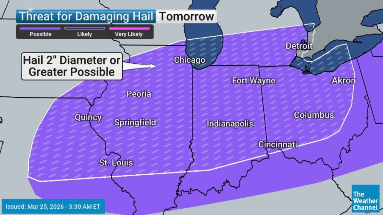
Large Hail Up To 2 Inches Possible
In addition to tornado potential, one of the primary concerns with this system is very large hail, with projections showing hailstones reaching up to 2 inches in diameter or greater.
This hail threat extends across a broad corridor, including Missouri, Illinois, Indiana, and Ohio, where atmospheric conditions support strong updrafts capable of producing damaging hail cores.
Storm Timing Points To Evening And Overnight Impact
Storm development is expected to begin by early evening hours, with activity intensifying as it tracks eastward. The system is forecast to continue through the night, increasing risks for residents while many are asleep.
The nighttime timing adds another layer of concern, as visibility is reduced and warnings may be harder to receive, especially if storms intensify quickly.
Severe Storm Structure Could Enhance Threats
Environmental conditions suggest storms may develop with organized structure, including supercells early in the event. These storm types are capable of producing:
Damaging wind gusts, large hail, and isolated tornadoes
As storms evolve, some may merge into lines, but embedded rotation and brief tornado spin-ups could still occur within these systems.
Areas Facing The Highest Concern
The core of the threat zone includes:
Central and eastern Illinois
Much of Indiana
Western and central Ohio
Southern portions of Michigan
This region aligns with the strongest overlap of instability and wind shear, which are key ingredients for severe storm development.
What Residents Should Watch Closely
With multiple hazards expected, residents across the impacted states should remain alert for:
Rapid storm development during evening hours
Severe thunderstorm warnings with hail reports
Possible tornado warnings late evening into overnight
Conditions may change quickly as storms move through the region.
Final Outlook On Thursday’s Severe Setup
Thursday’s weather setup presents a multi-hazard severe event across the Midwest, with tornado potential, large hail, and nighttime storms all contributing to elevated risk.
While not an extreme outbreak scenario, the TORCON Level 4 risk signals a meaningful chance for impactful severe weather, especially in densely populated areas.
Residents across Illinois, Indiana, Ohio, and Michigan should stay weather-aware and prepared as storms develop.
Stay with CabarrusWeekly.com for real-time updates and severe weather coverage as this system unfolds.