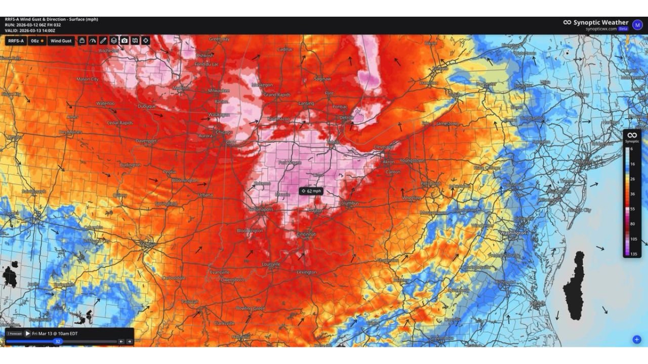
Ohio, Indiana, Michigan and Pennsylvania Brace for 60+ MPH Wind Gusts as Powerful System Targets Great Lakes and Mid-Atlantic
UNITED STATES — A powerful storm system is poised to unleash widespread damaging winds across the Great Lakes and Mid-Atlantic, with gusts potentially exceeding 60 mph from Indiana and Ohio through Michigan and into Pennsylvania.
Forecast wind guidance shows a broad corridor of intense surface gusts spreading across:
- Indiana, including Indianapolis and surrounding counties
- Ohio, including Columbus, Dayton and Cleveland
- Southern and central Michigan, including Detroit and Grand Rapids
- Western and central Pennsylvania, including Pittsburgh
Severe Criteria Could Be Met Without Thunderstorms
Meteorologists note that severe thunderstorm criteria begins at 58 mph. Forecast models indicate that many areas could meet or exceed that threshold even outside of organized severe storms.
Wind gust projections show:
- 55 to 65 mph across large portions of Indiana and Ohio
- Near or above 60 mph in parts of southern Michigan
- 50 to 60 mph gusts extending into western Pennsylvania
These winds are being driven by a strong pressure gradient and powerful upper-level dynamics associated with a deepening low-pressure system over the region.
Peak Wind Timing
The strongest winds are expected during the late morning through afternoon hours, when mixing of stronger winds aloft down to the surface becomes most efficient.
Cities including:
- Indianapolis, Indiana
- Columbus and Cleveland, Ohio
- Detroit, Michigan
- Pittsburgh, Pennsylvania
could see the highest gusts during this window.
Impacts: Damage and Power Outages Possible
With gusts potentially exceeding 60 mph, impacts may include:
- Downed tree limbs and isolated uprooted trees
- Scattered power outages
- Difficult travel, especially for high-profile vehicles
- Blowing debris and hazardous crosswinds on open highways
Areas along and south of the Great Lakes may experience particularly strong gusts due to channeling effects and enhanced mixing.
Not a Minor Wind Event
Forecasters emphasize this is not a routine breezy day. The wind field covers a large geographic area, increasing the potential for widespread impacts rather than isolated pockets of damage.
Even outside of thunderstorm activity, these gradient-driven winds alone may create conditions comparable to severe weather.
Bottom Line
Residents across Indiana, Ohio, Michigan and Pennsylvania should prepare for a day of potentially damaging winds, with gusts over 60 mph possible in some locations.
Securing outdoor items, charging electronic devices and preparing for possible power interruptions are recommended precautions.
CabarrusWeekly.com will continue to monitor this developing wind event and provide updates as conditions evolve.