Ohio, Pennsylvania, New York and New England Face Rising Snow and Ice Threat Thursday–Friday as Storm Track Uncertainty Clouds Exact Totals
NORTH CAROLINA — A developing late-week winter system is setting up the potential for snow and ice impacts across Ohio, Pennsylvania, New York and much of New England Thursday into Friday, with forecast confidence growing on impacts but still uncertain on exact totals.
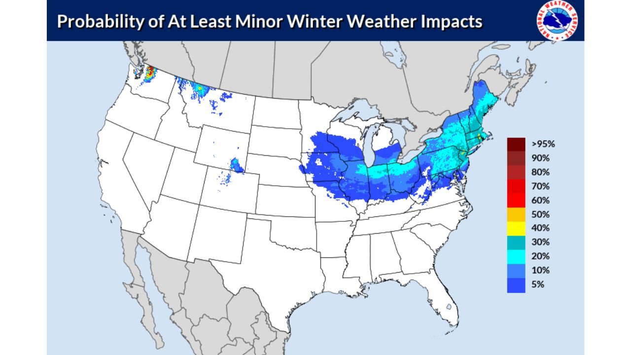
New probability guidance shows a broad and expanding zone of at least minor winter weather impacts stretching from the Midwest into the Northeast, signaling increasing travel concerns across multiple states.
Ohio and Indiana Enter the Core Impact Zone
Probability data highlights Ohio and Indiana within a more concentrated corridor of winter weather risk. Much of both states shows a measurable chance of at least minor impacts, including slick roads and accumulating precipitation.
Western and central Pennsylvania also fall within this expanding impact zone, with probabilities increasing eastward into the Appalachians.
If the colder air remains firmly in place, snowfall could be the dominant precipitation type. However, any subtle warming aloft could introduce sleet or freezing rain, especially in transition areas.
Pennsylvania and New York Could See Widespread Travel Issues
Across Pennsylvania and New York, probabilities increase notably, especially through western and central portions of both states.
Upstate New York appears particularly vulnerable to accumulating snowfall if the system tracks favorably for colder air. Meanwhile, parts of southern Pennsylvania could sit near a temperature boundary, raising concerns for mixed precipitation and icy surfaces.
Even minor accumulations in these states could create significant travel slowdowns during peak commute hours Thursday evening into Friday morning.
New England Monitoring Snow Versus Ice Setup
The outlook extends into Massachusetts, Connecticut, Rhode Island, Vermont, New Hampshire and Maine, where probabilities indicate at least a low to moderate chance of winter impacts.
Interior sections of Massachusetts, Vermont and New Hampshire would favor more snowfall under a colder scenario. Coastal areas, including parts of Connecticut and Rhode Island, could see a mix depending on how close warmer air tracks inland.
Because the storm’s exact path is still evolving, forecasters caution that snowfall and ice totals cannot yet be locked in. Small shifts north or south could dramatically change precipitation type and intensity.
Illinois, Missouri and Kentucky on the Southern Edge
The southern edge of the impact zone stretches into parts of Illinois, Missouri and Kentucky, where lower probabilities still suggest potential for light snow or mixed precipitation.
These areas appear more likely to experience lighter accumulations, but brief periods of wintry precipitation could still create localized slick spots, particularly on bridges and untreated roads.
Timing: Thursday, February 26 Through Early Friday, February 27
The system is expected to move through between Thursday afternoon and early Friday, spreading precipitation from west to east.
The highest travel disruption risk currently centers on Thursday night into early Friday morning across Ohio, Pennsylvania, New York and interior New England.
While this does not yet appear to be a high-end blizzard setup, the combination of snow and potential ice is enough to create at least minor winter weather impacts across multiple states.
What This Means for North Carolina
At this time, the primary winter weather threat remains north of North Carolina. Current probability guidance keeps the more significant impact corridor confined to the Ohio Valley and Northeast.
However, residents traveling toward Ohio, Pennsylvania, New York or New England later this week should monitor updates closely, as forecast adjustments are still possible.
As new data becomes available, snowfall and ice projections will become clearer. Until then, the key message is increasing confidence in impacts — but continued uncertainty in exact totals.
If you’re located in any of the impacted states or have travel plans this week, share what you’re seeing in your area and stay updated with ongoing coverage at CabarrusWeekly.com.