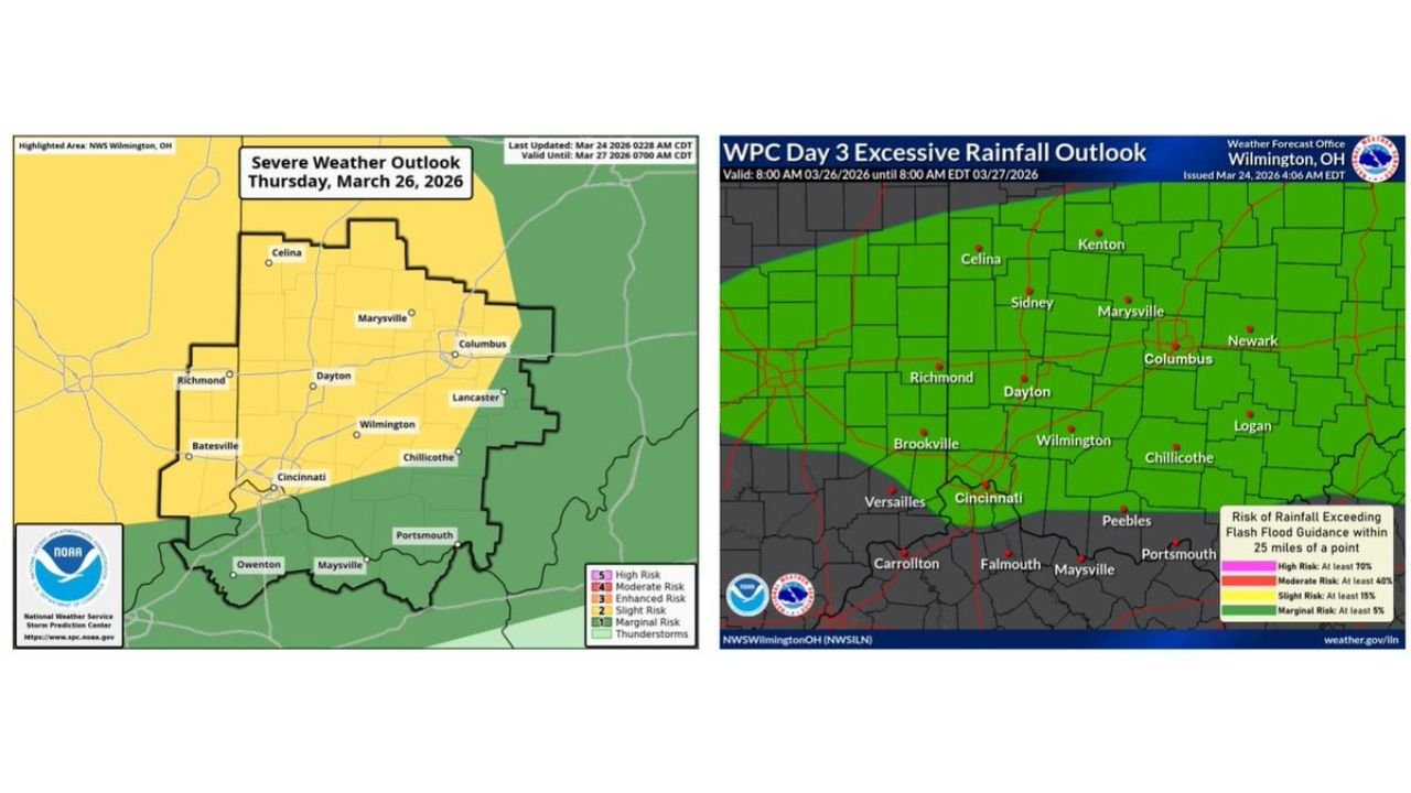
Ohio Severe Storm Threat Thursday Targets Cincinnati Columbus Dayton With Damaging Winds And Flood Risk Increasing Overnight
OHIO — A developing storm system moving in Thursday night is expected to bring a round of showers and thunderstorms across much of the state, with some storms turning strong to severe, particularly in central and southern Ohio.
Forecast data shows a cold front pushing into the region, triggering storms along and behind it, with the most active period expected late Thursday into the overnight hours.
Damaging Winds And Hail Lead The Threats
The primary concerns with this system are:
- Damaging wind gusts capable of downing trees and power lines
- Large hail in stronger storm cells
Cities including:
- Cincinnati
- Dayton
- Columbus
- Wilmington
fall within the zone where stronger storms are most likely to develop.
The setup suggests storms may organize into lines or clusters, increasing the potential for widespread wind damage rather than isolated impacts.
Heavy Rainfall Raises Flood Concerns
In addition to severe storms, locally heavy rainfall is expected, especially across central and southern Ohio.
Rainfall outlook data highlights:
- A broad area of concern for excessive rainfall
- Potential for rainfall rates high enough to overwhelm drainage systems
- Localized flooding, particularly in urban or low-lying areas
Communities from Cincinnati through Columbus and into eastern Ohio may see repeated rounds of rain, increasing the flooding risk.
Timing And Storm Evolution
The storm timeline currently points to:
- Thursday afternoon: Initial showers begin developing
- Thursday evening into overnight: Peak storm activity with severe potential
- Late night: Storms gradually shift east but rain may linger
Because the system is tied to a moving cold front, storms could redevelop along the boundary, prolonging impacts in some areas.
Widespread Coverage Expected Across Ohio
Unlike isolated storm setups, this event is expected to impact a large portion of the state, including:
- Western Ohio (Dayton region)
- Southwest Ohio (Cincinnati area)
- Central Ohio (Columbus region)
- Parts of eastern Ohio
This broad coverage increases the likelihood that multiple communities will experience strong storms rather than just isolated pockets.
Key Risks Residents Should Watch
Residents should prepare for:
- Sudden bursts of strong, damaging winds
- Hail capable of causing property damage
- Heavy rainfall leading to street flooding or ponding water
Even areas that avoid severe storms could still experience heavy rain and reduced visibility during nighttime hours.
Final Outlook
Thursday’s weather setup across Ohio is shaping up to be a multi-hazard event, with damaging winds and heavy rainfall posing the biggest threats, while hail remains possible in stronger storms.
With storms expected to arrive during the evening and overnight hours, residents are urged to stay weather-aware and have alerts enabled, as conditions could deteriorate quickly after sunset.
Stay with CabarrusWeekly.com for continued updates as this Thursday storm system develops.