Ohio Storm Line Pushes East Past Dayton and Lima Overnight as Severe Threat Fades Toward Columbus
OHIO — A powerful overnight line of storms raced across western and central Ohio early Monday morning, bringing heavy rain and thunder before quickly pushing east toward Columbus and surrounding counties.
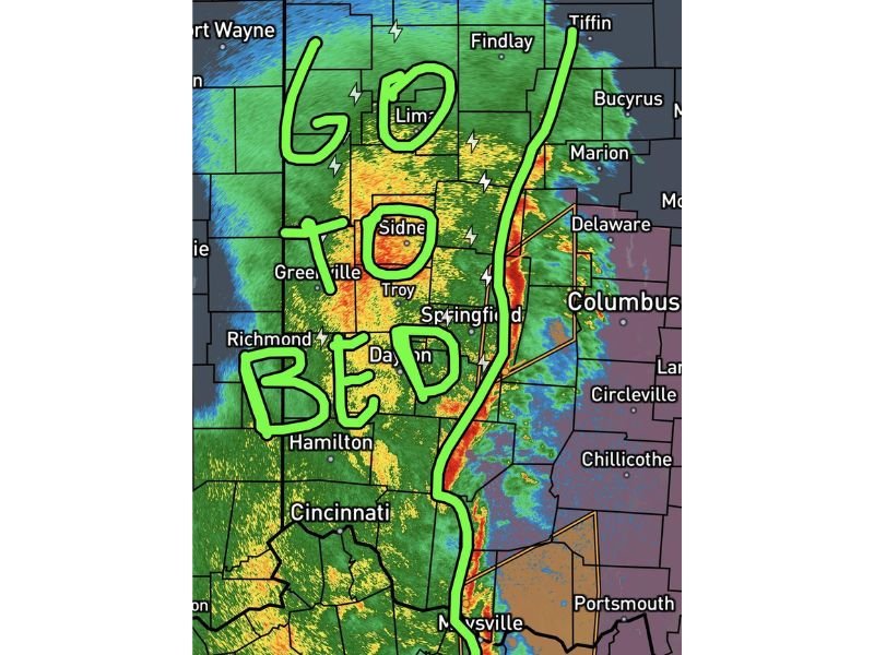
Weather updates around 2:15 a.m. Monday (March 16, 2026) indicated that the worst of the severe weather was already moving out of areas including Dayton, Lima, Sidney, Troy, and Greenville, allowing conditions to gradually improve behind the storm line.
Meteorologists described the system as the region’s “go to bed line,” signaling that the most intense part of the storm complex had already moved east and the severe threat was diminishing.
Storm Line Swept Across Western Ohio
Radar imagery showed the storm line stretching from Tiffin southward toward the Ohio River, forming a narrow but intense band of heavy rain and thunderstorms.
Cities impacted along the main storm corridor included:
- Lima
- Sidney
- Troy
- Dayton
- Springfield
- Greenville
- Findlay
- Marion
Communities in these areas experienced periods of heavy rain, lightning, and strong winds as the storms passed through overnight.
Severe Weather Threat Moving Toward Eastern Ohio
As the storms continued to move east, the line approached areas including:
- Columbus
- Delaware
- Circleville
- Chillicothe
- Portsmouth
Forecasters said the most intense part of the storm system was rapidly racing east, meaning the highest severe weather threat was already ending for much of western Ohio.
However, residents east of Columbus could still experience brief strong storms and heavy rainfall as the system continued to track across the state.
Heavy Rain and Thunder Continue Behind the Line
Even though the severe threat was fading, the radar showed widespread rain continuing behind the main line of storms.
This trailing rain shield stretched across much of western Ohio, including areas near Cincinnati, Hamilton, and Richmond, bringing additional rounds of showers and isolated thunder. While these storms were generally less severe, they could still produce brief downpours and occasional lightning.
Eastern Counties Improving by Early Morning
Forecasters expected the eastern portions of Logan, Champaign, Clark, and Clinton counties to see improving conditions by around 2:30 a.m., as the storm line pushed farther east.
By that point, most of western and central Ohio would be left with mainly light rain and cloud cover as the main severe threat moved away.
Residents Asked to Report Any Damage
Although the severe weather threat was quickly ending for many areas overnight, meteorologists encouraged residents to report any storm damage, fallen trees, or power outages that may have occurred as the storms moved through.
The fast-moving line of storms demonstrated how quickly severe weather can develop and pass through the region during overnight hours. Stay with CabarrusWeekly.com for continuing coverage of major weather events impacting communities across the United States.