Ohio Valley Faces Severe Weather Threat Tuesday as Strong Trough and Rising Instability Signal Potential for Strong to Severe Storms
OHIO VALLEY, UNITED STATES — Meteorologists are closely monitoring a developing severe weather setup across parts of the Ohio Valley heading into Tuesday, March 31, 2026. A strengthening trough pushing in from the north, combined with building moisture and atmospheric instability, could sustain strong to severe thunderstorms across the region by Tuesday afternoon and evening.
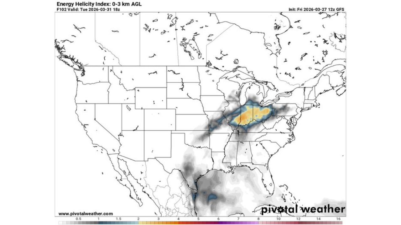
The data shown is from the GFS model initialized Friday, March 27, 2026 at 12z, valid for Tuesday, March 31 at 18z.
What the Atmosphere Is Telling Us
Three key ingredients are coming together that have forecasters watching this setup closely.
Upper-Level Trough — A well-defined 500 mb trough is diving southward into the region by Tuesday afternoon. Models are in general agreement on the trough’s position, which will provide the dynamic lift needed to trigger and sustain storm development across the Ohio Valley.
Moisture and Dew Points — Surface dew points across the Ohio Valley and surrounding states are forecast to climb into the mid 50s to low 60s°F by Tuesday afternoon — enough moisture to fuel thunderstorm development when combined with daytime heating. The Gulf moisture feed is clearly evident in the GFS dew point analysis, with the highest values concentrated across Kentucky, Indiana, Ohio, and Tennessee.
Instability (CAPE) — Surface-based CAPE values across the Ohio Valley are forecast to reach meaningful levels by Tuesday afternoon, particularly across Indiana, Ohio, and Kentucky. Elevated CAPE values suggest that storms that do develop will have sufficient energy to become strong to severe.
Storm-Relative Helicity (SRH) — The 0–3 km Energy Helicity Index shows the highest values concentrated directly over Indiana, Ohio, and Kentucky, with elevated readings extending into surrounding states. This is a key signal for rotating storm potential and adds to the concern for organized severe weather in this corridor.
Forecast Confidence Level
Medium confidence on the overall severe weather threat — models are in general agreement on the trough position, but the exact timing, coverage, and intensity of storms will depend on how much instability can build ahead of the system by Tuesday afternoon.
Lower confidence on specific storm mode and tornado potential — the helicity signal is notable, but whether storms can organize into discrete supercells or remain in a linear mode will be a critical factor in determining the overall severe weather threat type.
Who Needs to Watch This Closely
Based on the current GFS data, the states most at risk heading into Tuesday include:
| State | Key Threat |
|---|---|
| Indiana | Strong to severe storms, rotating storm potential |
| Ohio | Strong to severe storms, elevated instability |
| Kentucky | Severe storm threat, high helicity values |
| Tennessee | Peripheral severe storm risk |
| West Virginia | Fringe severe weather risk |
What Ohio Valley Residents Should Do Before Tuesday
Monitor forecasts closely through the weekend — this setup is still several days out and details will become clearer as Tuesday approaches. Do not rely on a single forecast.
Have a severe weather plan ready — know where your safe shelter location is before storms arrive, whether at home, work, or school.
Charge your devices — keep phones and backup batteries charged heading into Tuesday in case of power outages from severe storms.
Download a weather alert app — enable wireless emergency alerts on your phone so you receive tornado warnings and severe thunderstorm warnings the moment they are issued for your county.
Stay off the roads Tuesday afternoon and evening if severe storms are ongoing in your area — lightning, large hail, damaging winds, and poor visibility are all possible threats with this system.
The Bottom Line
The Ohio Valley is watching a potentially significant severe weather setup for Tuesday, March 31. A strong upper-level trough, building Gulf moisture, meaningful instability, and elevated storm-relative helicity are all signaling the potential for strong to severe thunderstorms across Indiana, Ohio, Kentucky, and surrounding states. This situation deserves close attention through the weekend as forecast confidence improves.
Bookmark cabarrusweekly.com and turn on notifications so you never miss a severe weather update, storm alert, or forecast change across the United States — delivered daily, before the weather hits.