Ohio, West Virginia, Kentucky and Pennsylvania Under Slight Risk as Severe Storms Bring Hail, Damaging Winds and Isolated Tornado Threat
OHIO VALLEY AND MID-ATLANTIC — A developing severe weather setup is expected to impact a large portion of the region Sunday, with thunderstorms capable of producing hail, strong winds, and a few isolated tornadoes.
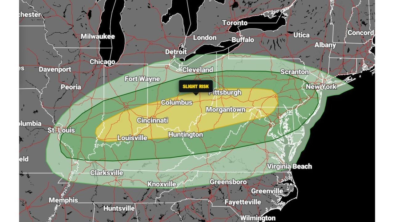
Slight Risk Zone Centers on Ohio Valley
The latest outlook highlights a Level 2 out of 5 Slight Risk stretching from central Kentucky through southern Ohio into West Virginia and western Pennsylvania.
Cities including Louisville, Cincinnati, Columbus, and Morgantown sit within this more active corridor, where conditions are most favorable for organized severe thunderstorms.
This zone represents the highest confidence area for impactful weather during the day.
Broader Storm Threat Extends Into Mid-Atlantic
A wider area under a marginal risk extends eastward into Virginia, Maryland, New Jersey, and New York, where thunderstorms are expected but may be more scattered or less intense.
Even outside the Slight Risk zone, storms could still produce brief heavy rain, gusty winds, and small hail, especially as activity spreads east.
Multiple Hazards Expected With This System
Forecasters are monitoring a combination of severe weather threats, including large hail, damaging wind gusts, and a few isolated tornadoes.
The environment supports storm organization, meaning some thunderstorms could become strong enough to produce localized damage, particularly where storm cells remain discrete before merging.
Storm Development and Movement
Storms are expected to develop across the Ohio Valley during the afternoon, then expand and move eastward into the central Appalachians and Mid-Atlantic by evening.
As storms progress, they may transition from isolated cells into clusters or lines, increasing the risk of widespread gusty winds.
This evolution is typical in spring setups where instability and frontal forcing align.
Key Areas to Watch
The corridor from Kentucky and Ohio into West Virginia and western Pennsylvania will likely see the most active conditions.
Farther east, cities like Richmond, Baltimore, and areas along the I-95 corridor should monitor storms later in the day as they move in.
Timing and intensity may vary, but conditions support at least scattered severe impacts across a broad region.
What This Means for Surrounding Regions
Areas south of the main risk zone may see weaker storms or just passing showers, but the overall pattern suggests a dynamic and changing weather day across much of the eastern United States.
Residents should stay alert for rapidly changing conditions, especially during peak afternoon and evening hours.
A Classic Spring Severe Weather Pattern
This setup reflects a typical early spring transition, where warm, unstable air interacts with an approaching system to produce thunderstorms.
The combination of instability, wind energy, and frontal lift is enough to support scattered severe storms across multiple states.
Stay with CabarrusWeekly.com for continued updates as this severe weather threat develops. If storms impact your area, share your conditions with the CabarrusWeekly.com community.