Oklahoma and Kansas Face Escalating Tornado Threat Friday Night as Discrete Supercells Fire Along Dryline and Low-Level Jet Intensifies After Sunset
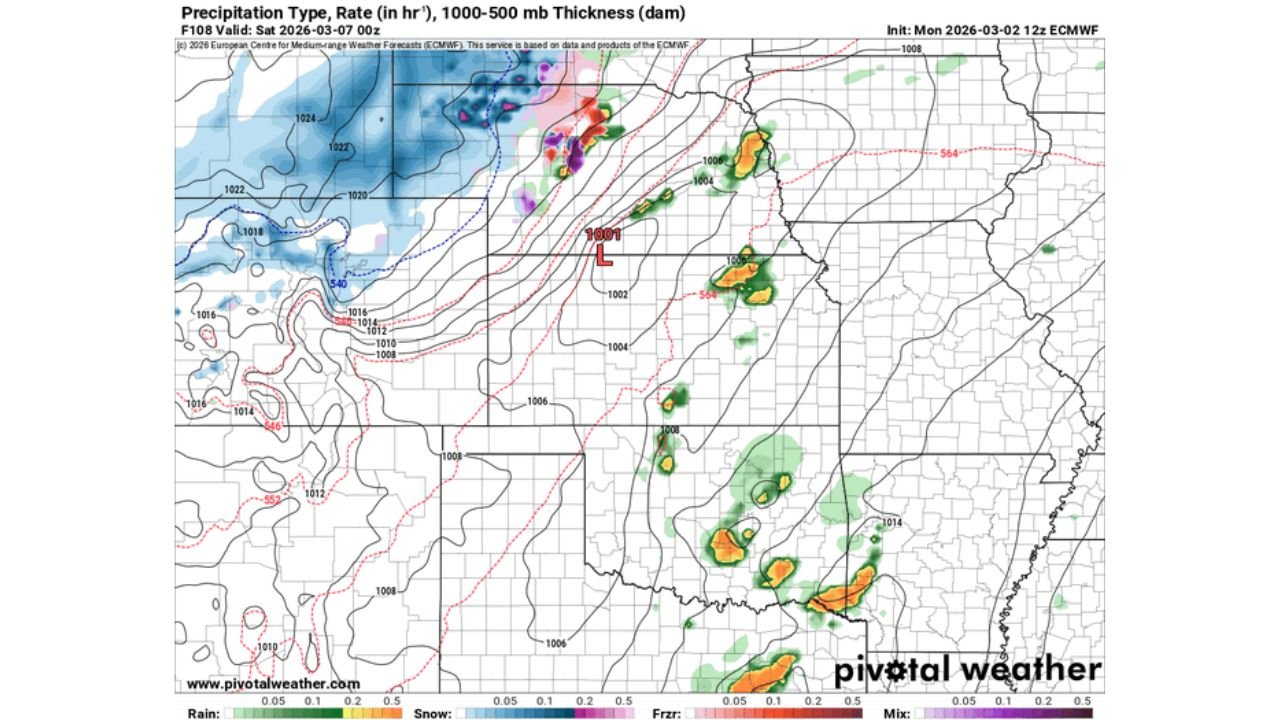
OKLAHOMA AND KANSAS — A more focused and potentially dangerous severe weather setup is emerging for Friday evening into early Saturday, March 6–7, 2026, with forecast guidance showing discrete supercell development across Oklahoma before the tornado threat expands north into Kansas after sunset.
Model data indicates that storm mode, timing, and low-level wind intensification will be critical in determining how significant the tornado risk becomes.
Dryline Setup Across Western and Central Oklahoma
By Friday afternoon, the 12z ECMWF model shows convection initiating:
- Along a sharpening dryline across western and central Oklahoma
- In association with an approaching upper-level shortwave
- Beneath strengthening mid-level wind fields
Early storms are expected to form in a corridor stretching from:
- Near Lawton, OK
- Through Oklahoma City, OK
- Toward Stillwater, OK
- Extending north toward Enid, OK
This discrete storm mode is important. Isolated supercells ahead of a developing line typically carry the highest tornado potential.
Southeast Oklahoma May See More Clustered Storms
Farther south and southeast into southeast Oklahoma, storms may form in a more clustered or “messy” fashion. That could limit discrete tornado potential in that region while shifting greater concern northward.
If storm interference becomes widespread in southern Oklahoma, the more favorable tornado corridor may align from central Oklahoma into southern Kansas.
Instability Builds From Oklahoma Into Southern Kansas
Mixed-layer CAPE values increase Friday afternoon across:
- Central Oklahoma
- North-central Oklahoma
- South-central Kansas
This instability axis overlaps with strengthening wind shear, creating a corridor where supercells could mature rapidly.
Cities near this instability gradient include:
- Oklahoma City, OK
- Stillwater, OK
- Ponca City, OK
- Wichita, KS
Strong Mid-Level Winds Overspread the Region
500 mb height and wind fields show increasing mid-level flow spreading into Oklahoma and Kansas during the late afternoon and evening hours.
This provides:
- Enhanced storm ventilation
- Stronger rotation potential
- Increased storm longevity
The overlap of strong mid-level flow with surface-based instability is a key ingredient in tornado-producing environments.
Tornado Threat Ramps Up Around 00z (7 PM CST)
The most notable escalation signal comes after sunset.
Model data shows the 850 mb low-level jet intensifying across Oklahoma and Kansas around 00z, dramatically increasing:
- Low-level moisture transport
- Wind shear in the lowest 1–3 km
- Storm-relative helicity
This means that storms ongoing during the early evening could become more dangerous after dark — particularly across:
- North-central Oklahoma
- The Oklahoma–Kansas border region
- Southern Kansas near Wichita
Evening and nighttime tornado setups often carry elevated risk due to reduced visibility and rapidly strengthening shear profiles.
Key Population Centers in the Corridor
Based on current projections, cities most likely to be impacted include:
- Oklahoma City, OK
- Stillwater, OK
- Enid, OK
- Ponca City, OK
- Wichita, KS
Storm mode evolution will be critical. If storms remain isolated through sunset, the tornado threat could be more pronounced. If they quickly merge into a line, damaging winds may become the dominant hazard.
Broader Severe Pattern Remains Active
This event is part of a broader multi-day severe weather pattern affecting:
- Texas
- Oklahoma
- Kansas
- Portions of the Midwest
As the system continues eastward in the coming days, downstream regions may eventually see impacts.
For Cabarrus County and the Carolinas, this serves as a reminder that early March marks the beginning of active severe weather season nationwide. Large-scale trough patterns originating in the Plains often progress toward the Southeast within several days.
CabarrusWeekly.com will continue monitoring the Oklahoma and Kansas severe weather setup and provide updates if the broader pattern trends closer to North Carolina.