Oklahoma and Kansas Face Increasing Severe Storm Threat March 4 and March 6 as Active Pattern Expands into Mid-March
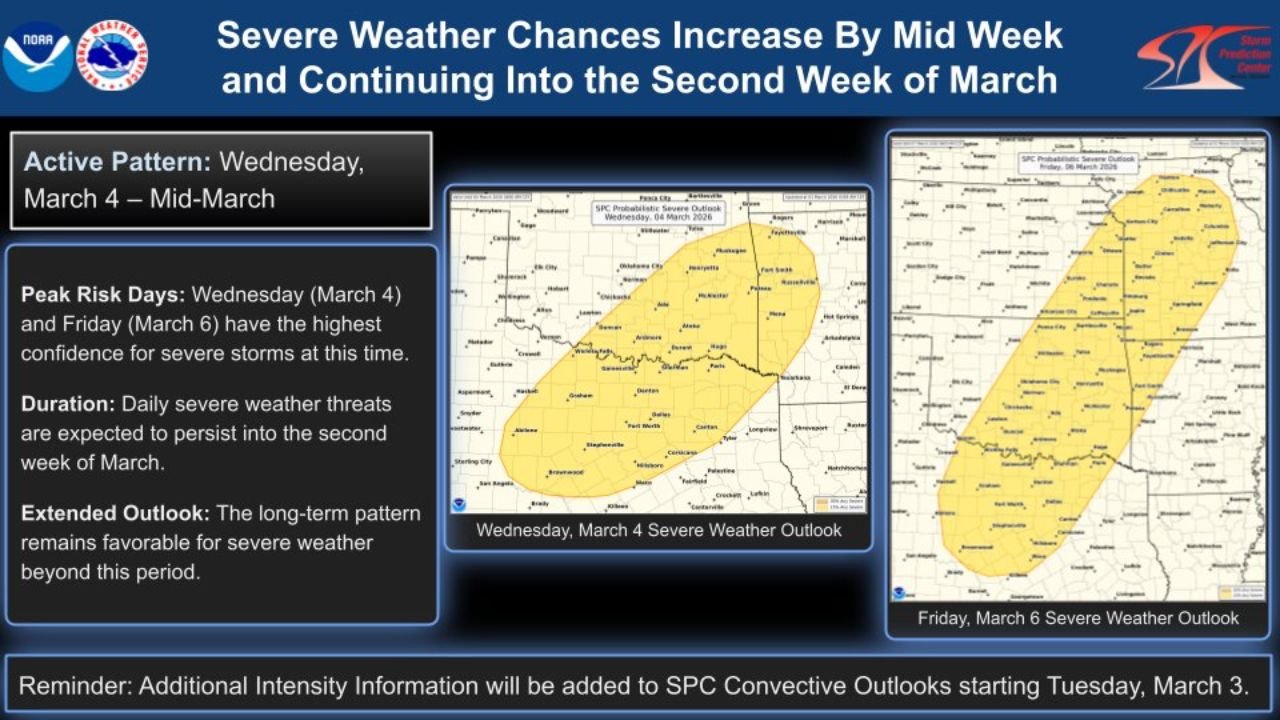
OKLAHOMA — Severe weather chances are expected to ramp up by midweek and continue into the second week of March, with Wednesday, March 4 and Friday, March 6 currently showing the highest confidence for organized severe storms across portions of Oklahoma and Kansas.
Forecasters indicate that this marks the beginning of a more active early-March pattern, with repeated daily storm threats possible beyond the initial peak days.
Active Pattern Begins Wednesday, March 4
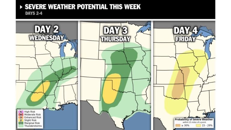
The first highlighted severe weather window arrives on Wednesday, March 4, with a broad risk area centered across Oklahoma and extending north into southern Kansas.
The outlook map shows a defined corridor stretching from central and eastern Oklahoma into portions of south-central Kansas, suggesting atmospheric ingredients will align for storm development.
This setup typically indicates:
Increasing instability across the southern Plains
Strengthening wind shear favorable for organized thunderstorms
Potential for severe hazards including damaging winds and hail
Confidence is already elevated several days in advance, which often signals a more organized storm environment rather than isolated activity.
Friday, March 6: Second High-Confidence Risk Day
The severe weather focus shifts and expands by Friday, March 6, with the highlighted area broadening northeastward.
The risk corridor on Friday extends from:
Central and eastern Oklahoma
Through Kansas
And into parts of Missouri
This northward expansion reflects a dynamic system lifting across the Plains. When multiple high-confidence days appear within the same week, it often indicates a sustained trough pattern capable of producing repeated rounds of thunderstorms.
Friday’s setup may feature:
Wider storm coverage than Wednesday
Stronger upper-level support
Expanded severe weather potential farther north
Severe Threats Expected to Continue Beyond This Week
Beyond March 6, the overall pattern remains favorable for additional severe weather episodes.
Forecast guidance suggests daily severe storm chances may persist into mid-March, indicating this is not a one-day event but rather the start of a prolonged active stretch.
Extended outlook language highlights:
A sustained favorable environment for severe weather
Ongoing storm chances into the second week of March
Additional forecast refinements expected beginning Tuesday, March 3
As newer convective outlooks are issued, intensity details and specific hazard probabilities will become clearer.
What This Means for the Southern Plains
For residents across Oklahoma, Kansas, and Missouri, the period from March 4 through at least March 6 will require close monitoring.
Early March severe weather in this region can bring:
Large hail
Damaging straight-line winds
Isolated tornado potential, depending on storm evolution
The multi-day nature of this pattern increases the risk of repeated impacts.
While the current outlook highlights the southern Plains, this type of progressive system often continues tracking eastward with time.
If you live in Oklahoma, Kansas, or Missouri and begin seeing changing weather conditions later this week, share your local observations with CabarrusWeekly.com as we continue tracking this developing severe weather pattern.