Oklahoma and Texas Warm Surge Triggers Early Growth but Late March Freeze Risk Still Looms Into April Despite Above Normal Outlook
OKLAHOMA AND NORTH TEXAS — Following a stretch of record-breaking March heat, a new concern is emerging across the region: the risk of late-season cold snaps that could still bring damaging freezes into April.
Early Warmth Accelerates Spring Growth
Recent days of record or near-record high temperatures across Oklahoma and northern Texas have rapidly pushed vegetation into early growth stages.
This early “green-up” may give the impression that winter is fully over, but meteorologists warn that this accelerated growth increases vulnerability to future cold snaps.
Plants and crops that begin developing too early are especially sensitive to sudden temperature drops.
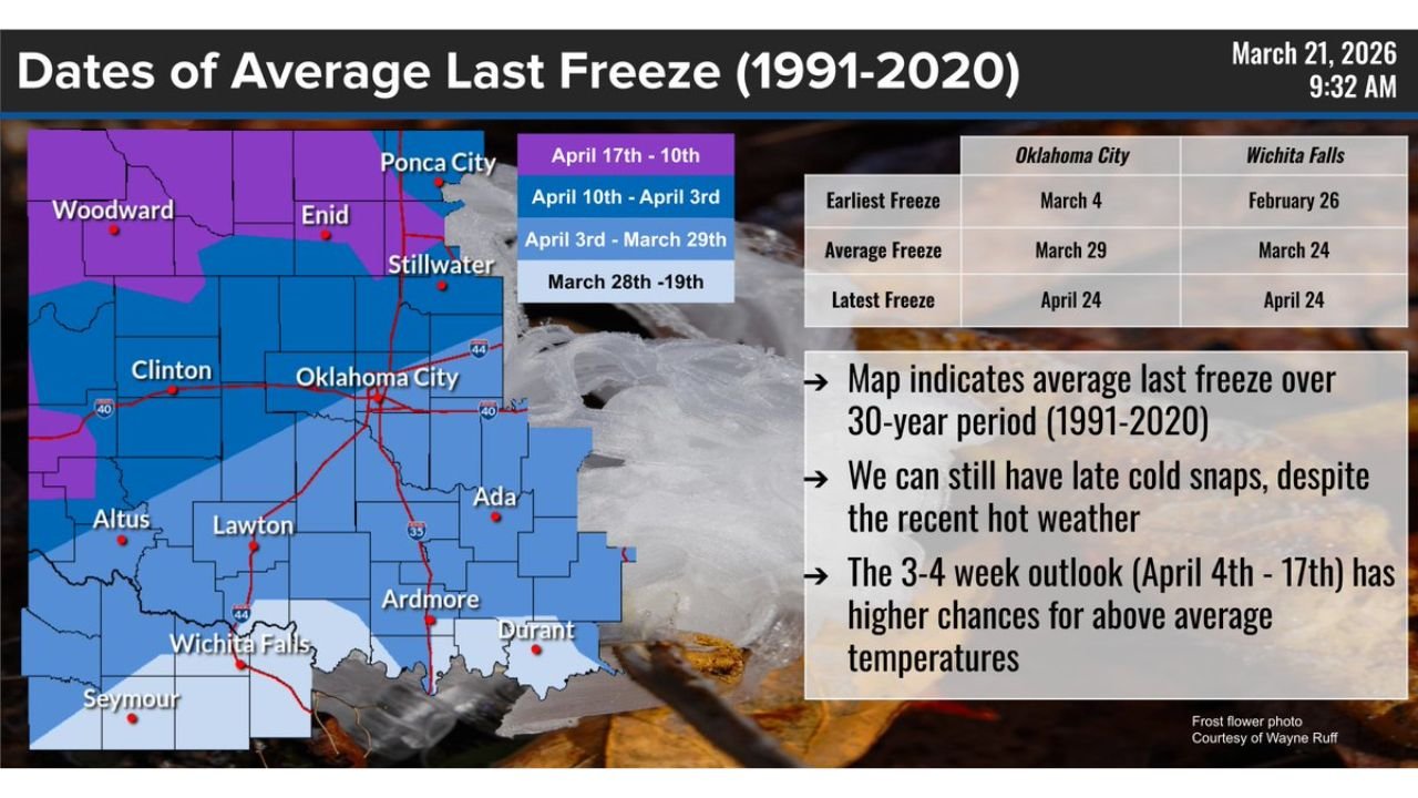
Average Last Freeze Dates Still Weeks Away
Climatological data shows that the average last freeze across much of Oklahoma occurs between late March and early April, depending on location.
Areas such as Oklahoma City typically see their last freeze around March 29, while northern and western parts of the state often extend into early to mid-April.
Even parts of north Texas, including Wichita Falls, have average last freeze dates near late March, meaning the window for freezing temperatures is still open.
Latest Freeze Potential Extends Into Late April
Historical data highlights that the latest freezes can occur as late as April 24 in both Oklahoma City and Wichita Falls.
This underscores the risk that even after prolonged warmth, a late-season cold event can still develop and impact the region.
Such late freezes, while less frequent, can be particularly damaging because vegetation is further along in its growth cycle.
Above-Normal Temperature Outlook Does Not Eliminate Risk
While longer-range forecasts indicate a higher probability of above-average temperatures into early April, this does not eliminate the possibility of brief cold outbreaks.
Spring is a transitional season, and sharp temperature swings are common, especially across the central United States.
Even during generally warm patterns, short-lived cold snaps can still occur and bring freezing conditions overnight.
Why Late Cold Snaps Remain a Concern
The same atmospheric patterns that allow for rapid warming can also shift quickly, allowing colder air masses to move southward.
This variability means that despite recent heat, the region is not yet fully safe from frost or freeze threats.
Meteorologists stress that confidence in sustained warmth increases later into April, but until then, caution is advised.
What This Means for Residents and Growers
Residents and agricultural interests should remain prepared for potential late freezes, especially over the next few weeks.
Protective measures for sensitive plants may still be necessary, particularly during clear nights when temperatures can drop quickly.
The key takeaway is that early warmth does not guarantee the end of freeze season, and vigilance remains important through early to mid-April.
Stay with CabarrusWeekly.com for continued updates on shifting spring weather patterns across the United States. If you’re seeing early blooms or preparing for potential cold snaps, share your experience with the CabarrusWeekly.com community.