Oklahoma, Arkansas, Tennessee, Kentucky, Virginia and North Carolina Face High-Impact Winter Storm With Ice, Heavy Snow and Dangerous Cold
UNITED STATES — A high-impact winter storm is increasingly likely to affect a broad corridor of the United States from Oklahoma and Arkansas through Tennessee, Kentucky, Virginia, North Carolina and into the Mid-Atlantic, beginning Friday and lasting through Sunday, with a dangerous mix of heavy snow, significant ice accumulation and extreme cold expected across multiple regions.
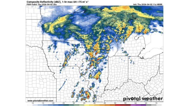
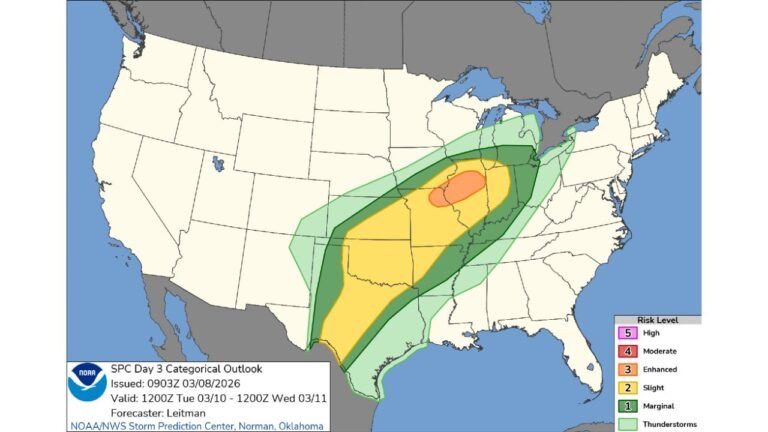
Latest ensemble guidance and impact maps show a long, continuous storm track stretching from the southern Plains to the East Coast, with multiple precipitation scenarios still on the table. While exact placement remains uncertain, confidence is growing that major winter impacts are likely somewhere within this corridor, particularly where cold air becomes locked in at the surface.
Three Storm Tracks Still in Play Across the Southeast and Mid-Atlantic
Forecast confidence continues to hinge on how the surface low tracks relative to entrenched cold air, resulting in three primary outcomes being monitored closely.
Track 1: Colder, Suppressed System Favors Heavy Snow
In the coldest solution, the low pressure system tracks farther south, keeping cold air firmly in place across Tennessee, southwest Virginia and northern North Carolina.
This scenario pushes the heavy snow line farther south, increasing the risk of mostly snow for higher elevations and northern counties. While some sleet or freezing rain would still be possible near transition zones, this is considered the least damaging ice outcome, though travel impacts would still be significant due to snow-covered roads.
Track 2: Mixed Precipitation With Prolonged Icy Conditions
A more central track allows warmer air aloft to surge northward over surface-level cold air, producing a snow-to-ice transition across much of central North Carolina, upstate South Carolina and parts of eastern Tennessee.
This creates a “glacier surface” scenario, where sleet and freezing rain compact into extremely hard ice, making roads nearly impossible to treat effectively. Extended periods of icy precipitation would significantly increase the risk of power outages and long-lasting travel disruptions.
Track 3: High-Impact Ice Storm Scenario
The most concerning outcome places the low farther inland, driving warm air aloft across a large region while cold air remains trapped near the ground.
Under this setup, Charlotte, Raleigh and areas extending toward the Virginia border could fall into a bullseye for freezing rain, with the potential for crippling ice accumulations. This is the scenario that raises the greatest concern for widespread tree damage, prolonged power outages and dangerous exposure risks.
Snowfall Potential From Oklahoma to the Mid-Atlantic
Beyond the ice threat, there is a solid chance for 6 to 12 inches of snow from southern Oklahoma through the Cumberland Plateau and into parts of Virginia and North Carolina, including the Richmond-to-Washington, D.C. corridor.
Ensemble probability maps show:
- Highest chances for double-digit snowfall in southern Oklahoma, the Cumberland Plateau and along the Virginia–North Carolina border
- A broad zone with 30–50% odds of more than 6 inches extending eastward
- Lower but still notable snow probabilities farther south where ice may dominate
Forecasters emphasize that the axis of heaviest snow will likely shift in the coming days as model guidance continues to refine storm placement.
Dangerous Cold and Wind Chills Add Another Layer of Risk
Even where snow or ice totals are lower, extreme cold following the storm will significantly worsen impacts. Apparent temperature forecasts show single-digit and sub-zero wind chills possible across parts of the Southeast and Mid-Atlantic early next week.
This prolonged cold snap will slow melting, increase the risk of refreezing each night, and heighten danger for anyone without reliable heat—especially if power outages become widespread due to ice-laden trees and power lines.
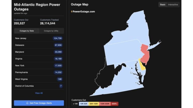
Power Outages and Safety Concerns Likely
With a high probability of freezing rain across populated corridors, officials are urging residents to prepare now for extended power disruptions, difficult travel conditions and hazardous cold exposure.
Anyone without a safe backup heat source is advised to identify warming shelters or alternate housing options before freezing rain begins, as conditions may deteriorate rapidly once ice starts accumulating.
What Happens Next
Confidence is high that precipitation will occur Saturday into Sunday, but precipitation type remains the key uncertainty. Small changes in storm track will have major consequences for who sees heavy snow versus crippling ice.
Updates over the next 24–48 hours will be critical as higher-resolution models come into focus.
If you’re tracking this storm or live anywhere from Oklahoma to the Mid-Atlantic, stay alert and prepared. For continued weather breakdowns, storm analysis and regional impact updates, keep following coverage on Cabarrusweekly.com.