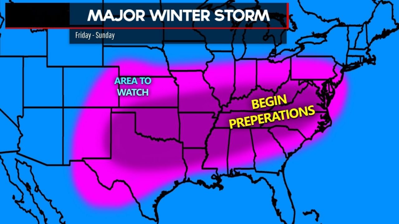
Oklahoma, Arkansas, Texas, Tennessee, Kentucky, Ohio, and Pennsylvania Face Major Winter Storm With Ice and Heavy Snow Likely This Weekend
UNITED STATES — A rapidly intensifying winter storm is becoming increasingly likely to impact a large portion of the country from Texas through the Mid-South, Ohio Valley, and into the East Coast late Friday through Sunday, with dangerous ice accumulation, heavy snow, and prolonged freezing temperatures all possible based on growing model agreement.
Forecast guidance and meteorological signals show a high-impact setup developing as Arctic air plunges south while strong storm energy moves out of the southern Plains. This combination is expected to create widespread wintry precipitation, with confidence highest across parts of Texas, Oklahoma, Arkansas, Tennessee, Kentucky, Ohio, West Virginia, Pennsylvania, and surrounding states.
Why This Storm Is Gaining Confidence
Multiple global weather models are now aligning on a classic cold-air damming and ice-storm pattern, with sub-freezing air locked in place near the surface while moisture overruns the cold layer from the south.
Key atmospheric signals supporting a major storm include:
- A deep Arctic air mass pushing into the southern and eastern U.S.
- Strong upper-level energy capable of producing long-duration precipitation
- A slow-moving system, increasing the risk for extended ice accretion
- Temperatures remaining below freezing for much of the weekend
This is the type of setup that historically produces widespread power outages and dangerous travel conditions, especially where freezing rain dominates.
Ice Storm Threat Across the Southern and Mid-South States
The highest concern at this stage is significant ice accumulation, particularly across:
- North and Central Texas
- Southern Oklahoma
- Arkansas
- Northern Louisiana
- Western and Central Tennessee
- Kentucky
In the most impacted areas, ice accretion between 0.50 and 1.00 inch is possible. Ice totals of this magnitude are capable of bringing down power lines, snapping tree limbs, and making roads impassable.
Because temperatures are expected to stay below freezing even after precipitation ends, ice may linger for days, prolonging impacts well into early next week.
Snow Potential Expands Into the Ohio Valley and Northeast
Farther north, colder air will favor heavy snow over ice, especially across:
- Ohio
- Indiana
- Pennsylvania
- West Virginia
- Interior Northeast states
While snowfall amounts are still uncertain, the pattern supports accumulating snow that could disrupt travel from Friday night through Sunday, particularly along major interstate corridors.
Timing and Duration of Impacts
- Friday: Wintry precipitation begins in Texas and the southern Plains
- Friday Night – Saturday: Peak impacts across the South and Mid-South
- Saturday – Sunday: Snow and ice expand north and east
- Sunday – Monday: Lingering freezing temperatures and slow recovery
Travel conditions could deteriorate rapidly Friday night, with road conditions remaining hazardous through the weekend.
What Remains Uncertain
Despite growing confidence in a major storm, some details are still evolving:
- Exact placement of the rain-to-ice-to-snow transition zones
- Which locations receive the heaviest ice totals
- How long freezing temperatures persist into early next week
Even small shifts in the storm track could significantly change local impacts, which is why residents are urged to monitor updates closely.
Preparation Is Strongly Advised
Forecasters are urging residents in the highlighted regions to begin preparations now, including:
- Stocking food, water, and medications
- Preparing for possible extended power outages
- Avoiding unnecessary travel once conditions worsen
- Checking on elderly neighbors and vulnerable family members
This is shaping up to be a high-impact winter storm, not a routine cold snap.
Stay Prepared
Winter storms of this magnitude can disrupt travel, utilities, and daily life for days. Stay weather-aware, review safety plans, and follow official updates as the forecast continues to refine.
For continued coverage of major weather events and how they may impact concerts, travel, and live events, stay connected with Cabarrusweekly.com and join the conversation with fellow readers as conditions evolve.