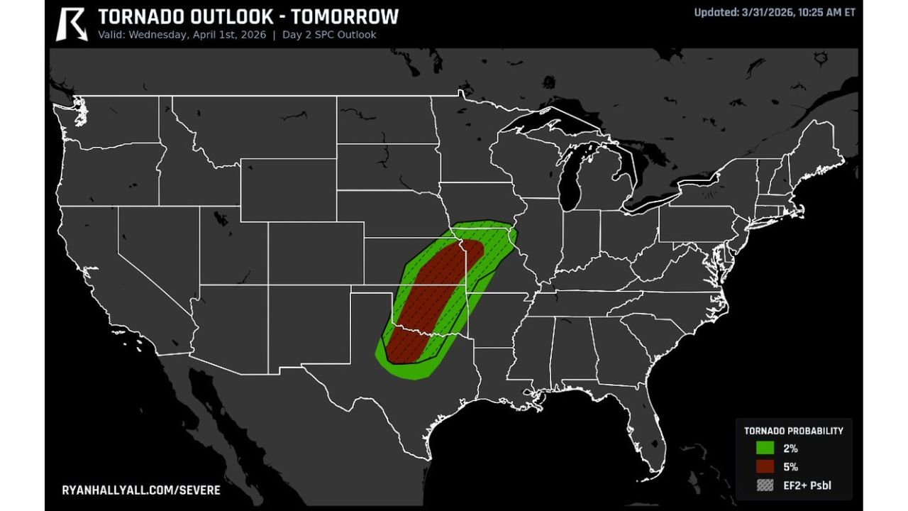
Oklahoma, Eastern Kansas, and Western Missouri Face Significant Tornado Threat Wednesday April 1 as Rotating Storms Fire Along the Dryline With Risk Increasing Into the Overnight Hours
UNITED STATES — A significant and concerning tornado threat is developing across the southern Plains for Wednesday, April 1, 2026. The Storm Prediction Center has issued a Day 2 tornado outlook placing Oklahoma, eastern Kansas, and western Missouri under a 5% tornado probability with the possibility of significant EF2 or stronger tornadoes — and forecasters are warning that the threat does not peak in the afternoon. It increases into the evening and overnight hours as low-level winds ramp up — making this one of the more dangerous setups of the spring season so far.
This outlook was updated March 31, 2026 at 10:25 AM ET, valid Wednesday, April 1, 2026.
Why This Setup Is Particularly Concerning
Three factors are combining Wednesday to create a tornado threat that deserves serious attention from residents across Oklahoma, eastern Kansas, and western Missouri.
Rotating storms firing along the dryline. The dryline — the boundary separating extremely dry air pushing east from the desert Southwest and warm, moist Gulf air streaming northward — is the ignition point for Wednesday’s storm development. By late afternoon, storms are expected to fire along this boundary and quickly organize into rotating supercell thunderstorms capable of producing tornadoes, large hail, and damaging straight-line winds. The dryline setup is one of the most classic and reliable tornado producers in the meteorological playbook for the southern Plains.
The tornado risk increases overnight — not decreases. This is the most important and alarming characteristic of Wednesday’s setup. Most severe weather events peak during the afternoon heating hours and diminish after sunset as instability drops. Wednesday is different. As low-level winds ramp up overnight, the wind shear profile that drives tornado-producing rotation actually strengthens into the evening and overnight hours. This means the most dangerous window for tornado development may come after dark — when most residents are less alert, visibility is minimal, and tornadoes are nearly impossible to see approaching.
Low cloud bases make this setup harder to survive. When cloud bases are low, the distance between the base of a thunderstorm and the ground is compressed. This means tornadoes can form and reach the surface faster, with less warning time. It also means tornadoes are more difficult for both storm spotters and residents to see visually — even during daylight hours. At night, with low cloud bases, a tornado can be completely invisible until it is on top of you.
Tornado Probability by Zone — Wednesday April 1
| Zone | Tornado Probability | Additional Risk |
|---|---|---|
| Central Oklahoma through eastern Kansas and western Missouri | 5% | EF2+ significant tornado possible |
| Broader surrounding area | 2% | General tornado threat |
What 5% Tornado Probability With EF2+ Hatching Actually Means
A 5% tornado probability sounds modest — but context matters enormously here. The Storm Prediction Center issues this level only when multiple tornadoes are considered a realistic outcome for the day, not just an isolated possibility. When that 5% zone also carries the EF2+ significant tornado hatching, it means forecasters believe at least some of the tornadoes that develop have the potential to be strong to violent — capable of causing significant structural damage, destroying poorly built homes, and being life-threatening to anyone caught without shelter.
EF2 tornadoes produce winds of 111 to 135 mph. EF3 and above — also possible in a hatched zone — produce winds exceeding 136 mph, capable of destroying well-built frame homes and turning vehicles into projectiles.
This is not a day to take chances across Oklahoma, eastern Kansas, and western Missouri.
Timing Breakdown — Wednesday April 1
Late Afternoon — Storms begin firing along the dryline across Oklahoma and into eastern Kansas. Initial rotating supercell development. First tornado threat window opens. Residents should already be in severe weather ready mode before storms arrive.
Evening Hours — Tornado threat increases as low-level winds strengthen and wind shear profiles become more favorable for sustained tornado-producing rotation. The most significant tornado potential of the day falls in this window — particularly across central and eastern Oklahoma and into western Missouri.
Overnight — The threat continues into the overnight hours as low-level jet strengthens further. This is the most dangerous window — tornadoes occurring after midnight are statistically deadlier than daytime tornadoes because residents are asleep and have no warning awareness until a siren or alert wakes them.
Forecast Confidence Level
High confidence on tornado threat across Oklahoma, eastern Kansas, and western Missouri Wednesday — the SPC Day 2 outlook with 5% probability and EF2+ hatching reflects high forecaster confidence on the overall setup.
High confidence on the evening and overnight threat increase** — low-level wind profiles are well-established and consistently support the overnight tornado risk across multiple model runs.
Medium confidence on exact storm initiation timing** — dryline storms can be finicky about exactly when and where they fire. The late afternoon window is the most likely initiation time but could shift earlier or later depending on surface heating and moisture convergence Wednesday.
What Oklahoma, Kansas, and Missouri Residents Must Do Before Wednesday Afternoon
Identify your tornado shelter now — not Wednesday evening. The overnight threat window means you need to know exactly where you are going before you go to bed Wednesday night. A basement is the safest option. An interior room on the lowest floor away from windows is the next best option. Mobile homes and vehicles offer no protection from tornadoes — if you live in a mobile home in the risk zone, identify a nearby sturdy building before Wednesday.
Set a weather alert on your phone tonight. Wireless Emergency Alerts are automatically pushed to your phone during tornado warnings — make sure your phone is not on silent Wednesday night. A tornado warning while you are asleep is only useful if something wakes you up. Consider a battery-powered weather radio as a backup alert method.
Do not wait for a tornado warning to take action. When a tornado watch is issued for your county Wednesday — and watches are very likely across the risk zone — treat it as your signal to finalize shelter plans and stay close to home. A watch means conditions are favorable for tornadoes. A warning means one has been detected or is imminent.
Keep your car’s gas tank full Wednesday. If evacuation becomes necessary or if you need to drive to a shelter, a full tank removes one potential obstacle during a rapidly evolving severe weather situation.
Check on neighbors and family members who may not have reliable severe weather alert systems — elderly residents, those without smartphones, and anyone living in mobile homes or other vulnerable structures in the risk zone.
The Bottom Line
Oklahoma, eastern Kansas, and western Missouri face a significant and particularly concerning tornado threat Wednesday, April 1. Rotating storms are expected to fire along the dryline by late afternoon, with the tornado threat increasing into the evening and overnight hours as low-level winds strengthen. A 5% tornado probability with EF2+ significant tornado potential covers the core risk zone. Low cloud bases will make tornadoes difficult to see and reduce visual warning time across the region. The overnight window is the most dangerous element of this setup — residents in the threat zone must have their shelter plans finalized and their alert systems active before going to bed Wednesday night. Do not wait.
Stay ahead of dangerous weather before it reaches your door. Visit cabarrusweekly.com for daily tornado outlooks, severe weather coverage, and storm alerts from across the United States — because knowing early is the difference that matters.