Oklahoma, Kansas, Missouri, Arkansas, Tennessee, Mississippi, Alabama, and Ohio Valley Brace for Active Early April Weather Pattern as ECMWF Signals 6 to 20-Plus Inches of Rain Through Mid-April
UNITED STATES — A significant and active weather pattern is taking shape across the central and eastern United States heading into early April 2026. Starting in the middle of the country and gradually shifting eastward, this pattern is expected to bring multiple rounds of rain and severe weather across a large portion of the nation — with the heaviest rainfall signal concentrated across the Plains, Ohio Valley, and Deep South.
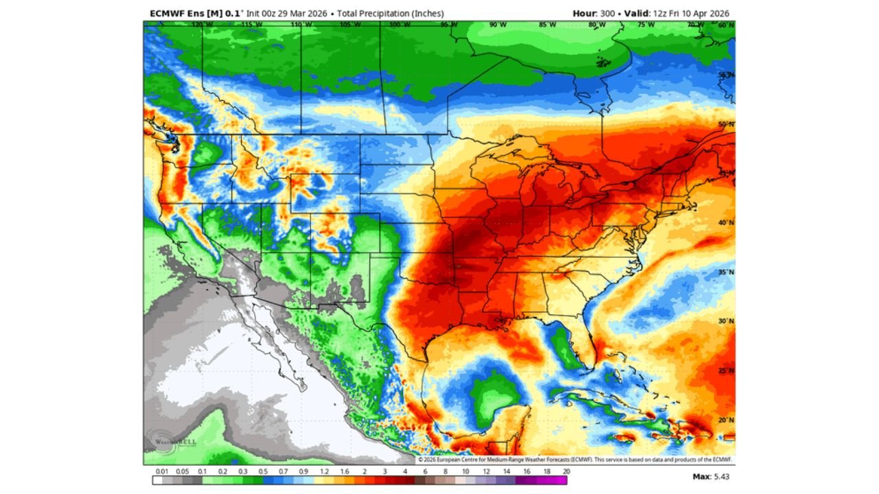
The precipitation forecast shown is from the ECMWF ensemble model, initialized March 29, 2026, valid through Friday, April 10, 2026.
How This Pattern Develops
The active stretch begins early in the week with some severe weather potential across the central United States — but forecasters are not overly concerned about the early window. The setup is relatively modest and not expected to produce anything significant on its own.
The story changes considerably heading into the late work week and the following weekend. A couple of upper-level atmospheric waves are set to push across the country in sequence, carrying the energy needed to organize and sustain strong to severe thunderstorms. What makes the late-week window stand out is timing — Gulf moisture will already be building across the region ahead of these systems, meaning the fuel for storm development will be loaded and waiting when the triggers arrive.
Forecasters are watching two specific windows most closely — one centered on the mid to late work week and another from Friday into the weekend — either of which could produce more significant weather impacts across a wide area.
What the ECMWF Precipitation Forecast Is Showing
The ECMWF ensemble total precipitation forecast through April 10 is one of the more striking model outputs seen so far this season for the central and eastern United States.
A large area of 6 to 20-plus inches of total rainfall is centered directly over Oklahoma, Kansas, Missouri, Arkansas, Tennessee, Mississippi, and Alabama. The heaviest signal on the map pushes into portions of the Ohio Valley — including Kentucky, Indiana, and southern Illinois — while a separate area of significant rainfall extends into the Southeast.
To put those numbers in perspective — most of these areas receive between 3 and 5 inches of rain in an average April. The ECMWF is currently showing totals that would double or triple normal monthly rainfall concentrated into roughly a two-week window.
Rainfall Signal by Region
| Region | Indicated Rainfall Signal |
|---|---|
| Oklahoma / Kansas | 6–12+ inches |
| Missouri / Arkansas | 8–16+ inches |
| Tennessee / Mississippi | 8–20+ inches |
| Alabama / Georgia | 6–12+ inches |
| Kentucky / Indiana / Ohio | 4–10+ inches |
| Louisiana | 4–8+ inches |
| Southeast coast | 2–6+ inches |
Forecast Confidence Level
High confidence that an active and wet weather pattern develops across the central and eastern US during early April — multiple ECMWF ensemble runs are in strong agreement on the overall signal.
Medium confidence on the exact rainfall totals by location — the ensemble mean shown represents a blend of many possible storm tracks. Individual storm positioning within the pattern will determine where the highest totals ultimately land.
Lower confidence on specific severe weather timing — the late work week window is the primary concern, but exact storm timing and organization will become much clearer by Tuesday and Wednesday of next week.
Why the Rain Is Welcome — and Also Worrying
It is worth noting that rain is desperately needed across many parts of the central and southern United States. Drought conditions have persisted across portions of the Plains, Midwest, and Deep South heading into spring — and a prolonged wet pattern would provide significant drought relief across these areas.
But there is a fine line between beneficial rain and dangerous flooding. When multiple rounds of heavy rainfall fall over the same region within days of each other, rivers and streams have no time to recede between events. Soil saturation builds quickly, and eventually the ground cannot absorb any more water — sending runoff directly into drainage systems, low-lying areas, and river channels.
Residents in flood-prone areas across Arkansas, Tennessee, Mississippi, Alabama, and the Ohio Valley should take this forecast seriously even at this early stage. Flash flooding and river flooding are both possible if the heavier scenarios from the ECMWF begin to verify.
What Residents Should Do Before the Pattern Arrives
Monitor your local forecast daily through the week. This pattern will come into much sharper focus by Tuesday and Wednesday as the first upper-level waves move within range. Do not rely on a single forecast snapshot from today.
Know your flood risk. If your home, road, or community has flooded before during heavy rain events, consider that risk elevated during this pattern. Identify your nearest high ground and know your evacuation route before the rain starts.
Do not drive through flooded roads. The most common cause of flood fatalities is driving into water of unknown depth. Even shallow, fast-moving water can sweep a vehicle off a road. When a road is flooded — turn around, do not drown.
Prepare for possible power outages if severe thunderstorms accompany the heavier rain events later in the week. Keep devices charged and have a backup power source ready heading into the late-week window.
The Bottom Line
An active and potentially significant weather pattern is developing across the central and eastern United States for early April. The ECMWF ensemble is signaling 6 to 20-plus inches of total rainfall across the Plains, Ohio Valley, and Deep South through April 10 — totals that would represent double or triple normal monthly rainfall for many of these areas. The late work week and Friday into the weekend carry the highest potential for organized severe weather and the heaviest rain. This pattern deserves attention starting now. Stay informed and stay ready as the week develops.
Stay ahead of dangerous weather before it reaches your door. Visit cabarrusweekly.com for daily storm alerts, heavy rain coverage, and forecast updates from across the United States — because knowing early is the difference that matters.