Oklahoma, Texas, Arkansas, Missouri, Illinois, Georgia, and the Mid-Atlantic Face Expansive, High-Impact Winter Storm With Snow, Ice, and Dangerous Cold From Friday Through Early Next Week
UNITED STATES — A sprawling and unusually complex winter storm is taking shape across a large portion of the central, southern, and eastern United States, with impacts expected to stretch more than 1,500 miles from West Texas to the Mid-Atlantic and East Coast. Forecast confidence has increased that this system will bring heavy snow, sleet, freezing rain, strong winds, and lingering extreme cold, creating dangerous travel conditions and widespread disruptions from Friday into early next week.
Meteorologists emphasize that while exact snowfall and ice totals are still being refined, the scale and reach of this storm are now well-established, making preparation critical across multiple regions.
A Storm Affecting More Than Half the U.S. Population
By early Sunday morning, forecasts show this storm becoming most widespread around 4 a.m., with snow, sleet, or freezing rain impacting roughly 193 million people — more than 56 percent of the contiguous United States population at the same time. This places the system among the more significant winter storms in recent years based on geographic coverage alone.
Model guidance shows a broad swath of at least moderate snow probabilities, with multiple regions facing a realistic chance of 6 inches or more, particularly across the central Plains, Midwest, and portions of the Ohio Valley and Mid-Atlantic.
Oklahoma Upgraded to Winter Storm Warning as Snow Potential Increases
Oklahoma has now been upgraded to a Winter Storm Warning, signaling a heightened risk for dangerous conditions. Recent model runs — including the GFS — have suggested the potential for very high snow totals, in some scenarios exceeding 12 inches, with isolated projections reaching higher amounts.
Forecasters caution that these extreme totals represent upper-end model outcomes, not guarantees. Official forecasts currently lean toward lower but still impactful accumulations, yet consistency in recent model runs means higher-end scenarios cannot be dismissed, especially with the storm only days away.
Strong winds combined with heavy snow could significantly reduce visibility, making travel extremely hazardous across much of the state.
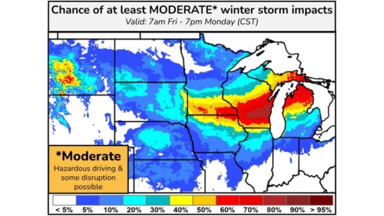
Snowfall Probabilities Increase From the Plains to the Mid-Atlantic
Probability maps show a long corridor of elevated confidence for 6-inch-plus snowfall extending from parts of Texas and Oklahoma through Arkansas, Missouri, Kentucky, and into the Ohio Valley and central Appalachians.
Several areas — including parts of West Virginia, western Maryland, and southern Pennsylvania — now show 70 to 90 percent probabilities of reaching or exceeding 6 inches of snow. This aligns with growing concern for major travel disruptions, especially along interstate corridors.
Illinois: Sharp North-to-South Gradient in Snowfall
Illinois will likely see dramatically different impacts depending on location.
- Northern Illinois: Snow is expected to arrive Saturday afternoon into Sunday morning, with lighter totals overall, generally 1–3 inches, though lake enhancement could add locally higher amounts near Lake Michigan.
- Central Illinois: Accumulations increase significantly, with 3–6 inches possible.
- Southern Illinois: The axis of heavier snow may settle here, where 6–12 inches or more remain possible depending on storm track.
Small shifts in the low-pressure path could substantially change where the heaviest snow ultimately falls.
Georgia and the Southeast: Ice, Snow, and CAD Complications
Across north Georgia and the Atlanta metro, forecasters are closely monitoring cold air damming (CAD) — a shallow but stubborn wedge of cold air that often determines precipitation type in the Southeast.
Current outlooks suggest:
- Northern Georgia: Higher risk for snow and sleet, with gusty winds.
- Metro Atlanta and surrounding areas: A mix of freezing rain, sleet, and rain, with ice accumulations potentially reaching 0.10 to 0.50 inches in some locations.
- Farther south: Lower confidence but still a notable risk of freezing rain if cold air presses farther south than expected.
Even modest ice amounts could lead to power outages, downed trees, and dangerous road conditions.
Mid-Atlantic and DMV See Rare High-End Winter Storm Signal
The DC, Maryland, and Virginia region has been placed under a rare high winter storm threat, the first of its kind for the area since 2016. Confidence is increasing for significant travel delays, closures, and prolonged impacts, especially as colder air lingers into the following week.
While snowfall totals remain uncertain, forecasters note that model confidence and ensemble agreement are unusually strong, warranting early preparation.
Timing: Conditions Deteriorate Rapidly Once Precipitation Begins
Arrival timing varies by region, but once frozen precipitation begins, conditions are expected to worsen quickly.
- Friday afternoon: Precipitation begins across parts of Texas, Arkansas, and Oklahoma.
- Friday evening into overnight: Snow and ice spread eastward.
- Saturday through Sunday: Peak impacts across much of the Midwest, Southeast, and Mid-Atlantic.
- Early next week: Lingering snow cover and bitter cold may prolong hazardous conditions.
Officials stress that even if precipitation tapers off, dangerously cold temperatures could extend impacts well beyond the storm itself.
Bottom Line
This winter storm is notable not just for snowfall totals, but for its enormous footprint, multi-hazard nature, and prolonged impacts. With snow, ice, strong winds, and extreme cold all in play, residents across affected states are urged to finalize preparations, limit travel when possible, and stay alert for forecast updates as details continue to evolve.
More refined accumulation maps and warnings are expected as the event draws closer.