Oklahoma, Texas Face Friday Severe Storm Window as Oklahoma City, Wichita Falls and Lawton Brace for Evening Hail and 65 MPH Winds
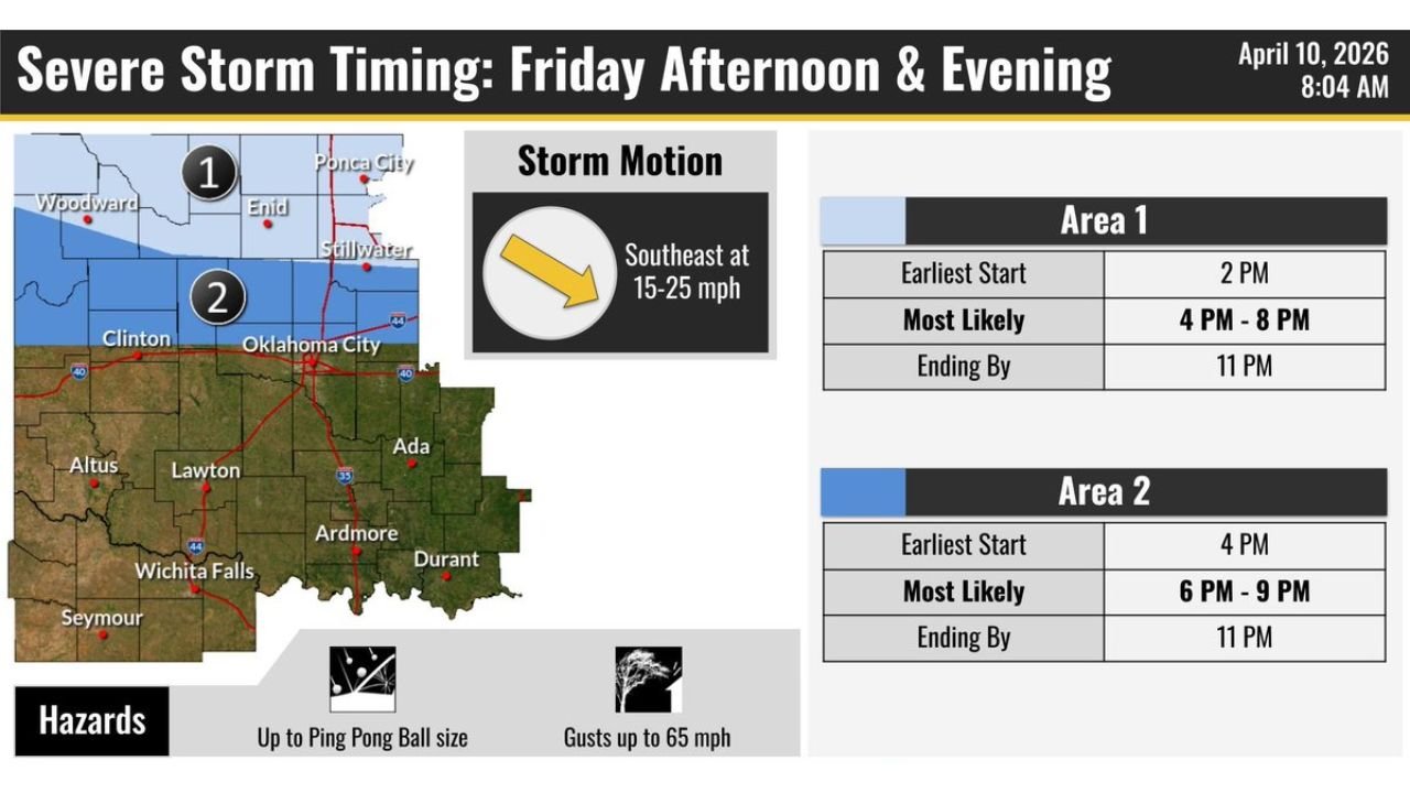
OKLAHOMA — A targeted severe weather setup is expected Friday afternoon and evening across Oklahoma and parts of North Texas, with the greatest concern centered around Oklahoma City, Lawton, Wichita Falls, and surrounding areas.
According to the latest timing outlook, storms are expected to develop in two main waves, bringing a risk of hail up to ping pong ball size and wind gusts reaching 65 mph.
Storm Timing Breakdown Across Oklahoma
The forecast divides the region into two primary impact zones, each with a slightly different timeline:
Area 1: Northern and Central Oklahoma Including Oklahoma City
- Earliest storm development: Around 2 PM
- Most likely severe window: 4 PM to 8 PM
- Storms ending by: Around 11 PM
This area includes locations such as Enid, Ponca City, Stillwater, and Oklahoma City, where storms could begin earlier in the afternoon and gradually intensify into the evening.
Area 2: Southern Oklahoma into North Texas
- Earliest storm development: Around 4 PM
- Most likely severe window: 6 PM to 9 PM
- Storms ending by: Around 11 PM
Cities like Lawton, Ardmore, Durant, and Wichita Falls fall within this zone, where storms are expected to arrive later but may still become strong during peak evening hours.
Storm Movement and Setup
Storms are expected to move southeast at 15 to 25 mph, meaning areas to the southeast of initial development zones could see quick-moving storm cells pushing through during the evening commute and nighttime hours.
This motion increases the chance of multiple communities being impacted in a short time window.
Main Hazards Residents Should Watch
The primary threats with these storms include:
- Hail up to ping pong ball size, which can damage vehicles and roofs
- Wind gusts up to 65 mph, capable of downing tree limbs and causing isolated power outages
While tornado risk is not highlighted as the primary concern in this setup, strong storm cores could still briefly intensify, so residents should remain alert.
Where the Greatest Concern Lies
The highest concentration of storm activity is expected from north Texas through central Oklahoma, forming a corridor that includes:
- Wichita Falls
- Lawton
- Oklahoma City
- Clinton
This region may see the most organized storm development, especially during the late afternoon into early evening period.
What This Means for Friday Plans
Residents across Oklahoma and nearby Texas areas should prepare for:
- Potential disruptions during evening travel hours
- Rapid changes in weather conditions
- Short bursts of severe weather rather than long-lasting storms
Outdoor plans during the 4 PM to 9 PM window may be impacted, particularly in central and southern Oklahoma.
Final Outlook
While this is not expected to be a widespread outbreak, Friday’s setup carries enough energy to produce locally strong storms, especially across central and southern Oklahoma into north Texas.
The combination of timing, storm motion, and hail/wind threats makes this a situation worth monitoring closely through the day.
Stay with CabarrusWeekly.com for continued updates as conditions evolve across the region.