Opening Week of Tornado Season Targets Texas, Oklahoma and the Lower Mississippi Valley — Severe Storm Threat Expands Wednesday Through Saturday
UNITED STATES — The 2026 tornado season is ramping up in dramatic fashion, with a multi-day severe weather setup expected to stretch from Texas and Oklahoma northward into the Midwest before shifting toward Dixie Alley early next week.
Forecast outlooks issued March 2–3 outline an active pattern from Wednesday through Saturday, with tornado chances, large hail, and damaging wind threats shifting across multiple states.
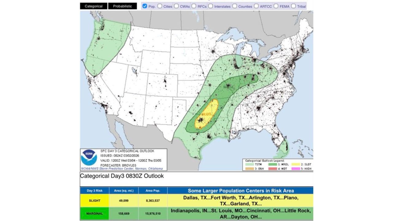
Day 3 Outlook: Enhanced Risk Centered Over North Texas
The Day 3 categorical outlook (valid Wednesday) highlights:
- Slight Risk (SLGT) across portions of north and central Texas into southern Oklahoma
- A broader Marginal Risk (MRGL) extending northeast toward parts of the Midwest
Population centers specifically listed within the risk area include:
- Dallas, TX
- Fort Worth, TX
- Arlington, TX
- Plano, TX
- Garland, TX
- Indianapolis, IN
- St. Louis, MO
- Cincinnati, OH
- Little Rock, AR
- Dayton, OH
This corridor suggests strong thunderstorms capable of producing tornadoes, especially across the Dallas–Fort Worth Metroplex and surrounding North Texas region.
Day 4 (Thursday): 15% Severe Risk Across West-Central Texas and Southwest Oklahoma
For Thursday (Day 4), a 15% severe weather probability area is outlined across:
- Abilene, TX
- Wichita Falls, TX
- Lawton, OK
- San Angelo, TX
- Big Spring, TX
This zone signals increasing confidence in organized severe thunderstorms, potentially including tornado development as instability and wind shear increase across the southern Plains.
Day 5 (Friday): Risk Expands North and East
By Friday (Day 5), the severe threat broadens across a larger area including:
- Dallas, TX
- Fort Worth, TX
- Oklahoma City, OK
- Kansas City, MO
- Tulsa, OK
A 15% probability area suggests a more widespread severe setup with the potential for:
- Tornadoes
- Large hail
- Damaging straight-line winds
Storm chasers are already preparing for what appears to be an extended severe weather window across the Plains.
Day 6 (Saturday): Southern Plains Remain in Play
On Saturday (Day 6), the risk area shifts but remains focused over parts of:
- Dallas, TX
- Fort Worth, TX
- Arlington, TX
- Plano, TX
- Garland, TX
This indicates that North Texas could face multiple rounds of severe weather through the end of the week.
Early Next Week: Potential Shift Toward Dixie Alley
Longer-range signals suggest a “final trough ejection” early next week that may shift the severe weather focus into Dixie Alley, including portions of:
- Mississippi
- Alabama
- Louisiana
- Western Georgia
Historically, this region is particularly vulnerable to nighttime tornadoes and fast-moving systems.
What This Means for Cabarrus County, NC
While the immediate threat remains centered in the Plains and Midwest, multi-day severe weather patterns often shift eastward. If the trough progresses as forecast, portions of the Southeast — including North Carolina — could eventually see impacts early next week.
Cabarrus County residents should:
- Monitor forecast updates heading into the weekend
- Review tornado safety plans
- Ensure weather alerts are enabled
Even when the highest probabilities remain west, pattern shifts can occur quickly during early spring setups.
CabarrusWeekly.com will continue tracking this developing severe weather pattern and provide updates if the risk corridor trends closer to North Carolina.