Pennsylvania, New Jersey and New York Storm Track Uncertainty Grows as Model Shift Expands Snow Shield North Toward I-78 and I-84 Corridor
NEW YORK — Forecast confidence is being tested tonight as updated model guidance shows a noticeable northward shift in the developing coastal storm, expanding the potential snow shield closer to the Interstate 78 and Interstate 84 corridors.
Earlier guidance kept the heaviest precipitation primarily offshore and across southern New Jersey. However, the latest run introduces a meaningful adjustment, dropping more energy into the southern trough and altering the storm’s precipitation footprint across the Mid-Atlantic and Northeast.
Small Energy Shift, Big Difference in Snow Coverage
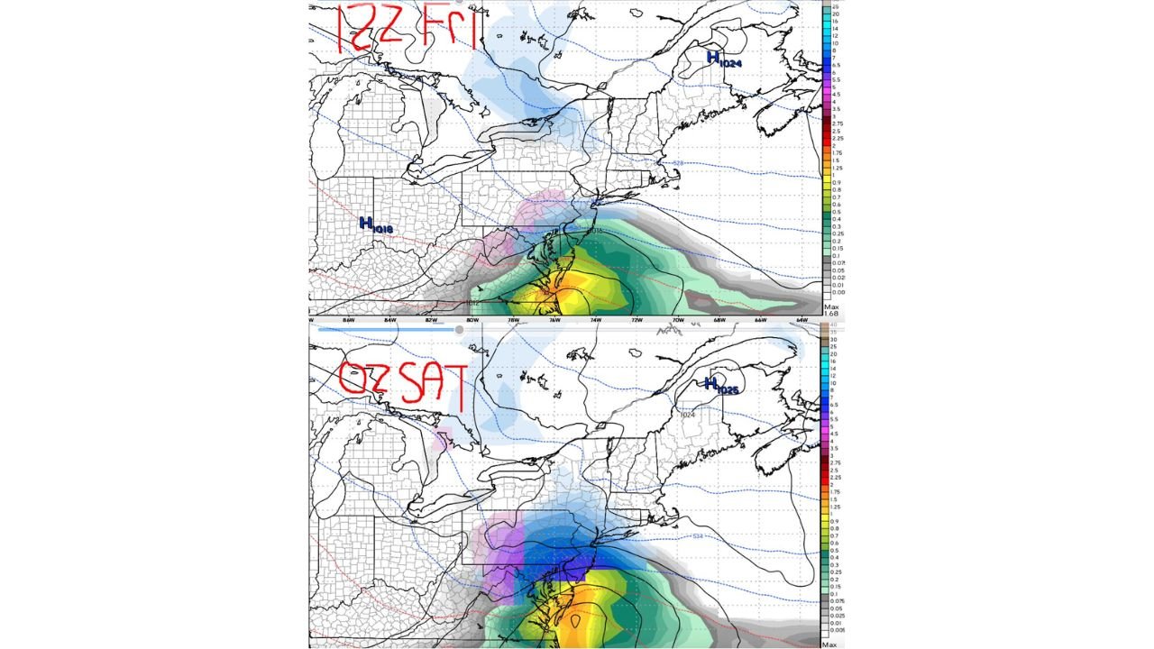
Side-by-side comparisons between the earlier 12z Friday run and the newer 00z Saturday run highlight how subtle upper-level changes dramatically reshape the precipitation field.
In the earlier solution:
• The heavier precipitation band remains focused offshore and over southern New Jersey.
• Interior Pennsylvania and southern New York see lighter totals.
• The northern edge of the snow shield stays relatively suppressed.
In the latest run:
• The precipitation shield expands northward.
• Snow reaches deeper into eastern Pennsylvania and northern New Jersey.
• Southern New York, especially near the lower Hudson Valley, comes closer to steadier snowfall.
This type of adjustment demonstrates how sensitive coastal systems can be when upper-level energy phases more efficiently.
I-78 to I-84 Corridor Now in Focus
The zone between Interstate 78 and Interstate 84 is increasingly important.
This corridor includes:
• Eastern Pennsylvania
• Northern New Jersey
• Southern New York
In the newer guidance, colder air remains entrenched north of the surface low track while stronger lift wraps northwest of the developing coastal low. That alignment supports a more expansive snow shield inland.
Even modest changes in the storm’s exact track could determine whether communities see a light nuisance snowfall or a more organized accumulating event.
High Pressure to the North Still Matters
High pressure remains positioned across parts of northern New England and eastern Canada, helping maintain colder air across interior New York and northern New England.
The strength and placement of this high will influence how far north the storm’s heavier precipitation can push. If the high holds firm, it could limit northward expansion. If it weakens or shifts slightly, snowfall could extend farther inland.
Why Confidence Remains Limited
This system is still far enough out that fine-scale details cannot be considered locked in.
The current setup shows:
• A coastal low developing near the Mid-Atlantic.
• A southern stream energy injection altering storm structure.
• A precipitation gradient that is tight and sensitive to small shifts.
When precipitation gradients are sharp, even a 50–75 mile adjustment can significantly change who sees meaningful snow.
That is why forecasters caution against locking into one solution too early.
What to Watch Next
Over the next 24 to 48 hours, key factors include:
• How the southern trough evolves.
• Whether model consensus continues trending north.
• The strength of cold air locked in across Pennsylvania, New Jersey and New York.
If the northward shift trend continues, snow totals could increase for areas previously considered on the northern fringe.
If the track wobbles back south, the heavier precipitation shield could remain focused closer to the coast.
For now, residents across eastern Pennsylvania, northern New Jersey and southern New York should monitor updates closely as confidence improves.
We’ll continue analyzing each model cycle and provide updates as this evolving coastal system becomes clearer.
Residents across eastern Pennsylvania, northern New Jersey and southern New York should keep checking for updated forecasts as model trends continue to shift. If you’re along the I-78 or I-84 corridor and begin seeing snow develop, send us your reports and totals at CabarrusWeekly.com so we can track how this evolving coastal storm is unfolding in real time.