Pennsylvania, Ohio, Indiana and Appalachians Face Sunday Severe Storm Threat With Large Hail Risk and Isolated Tornado Potential
NORTH CAROLINA — A developing storm system is expected to bring a round of severe weather on Sunday, targeting parts of the Midwest and Appalachians with increasing risks of hail and damaging storms.
Storm Setup Driven by Sagging Cold Front
A stationary boundary shifting southward as a cold front will act as the main trigger for storm development. Ahead of this boundary, the atmosphere will become increasingly unstable, especially across areas west of the Appalachian Mountains.
This setup will allow energy to build through the day before being released rapidly, leading to clusters of thunderstorms developing by afternoon and evening.
Elevated Storms Increase Hail Risk in Pennsylvania
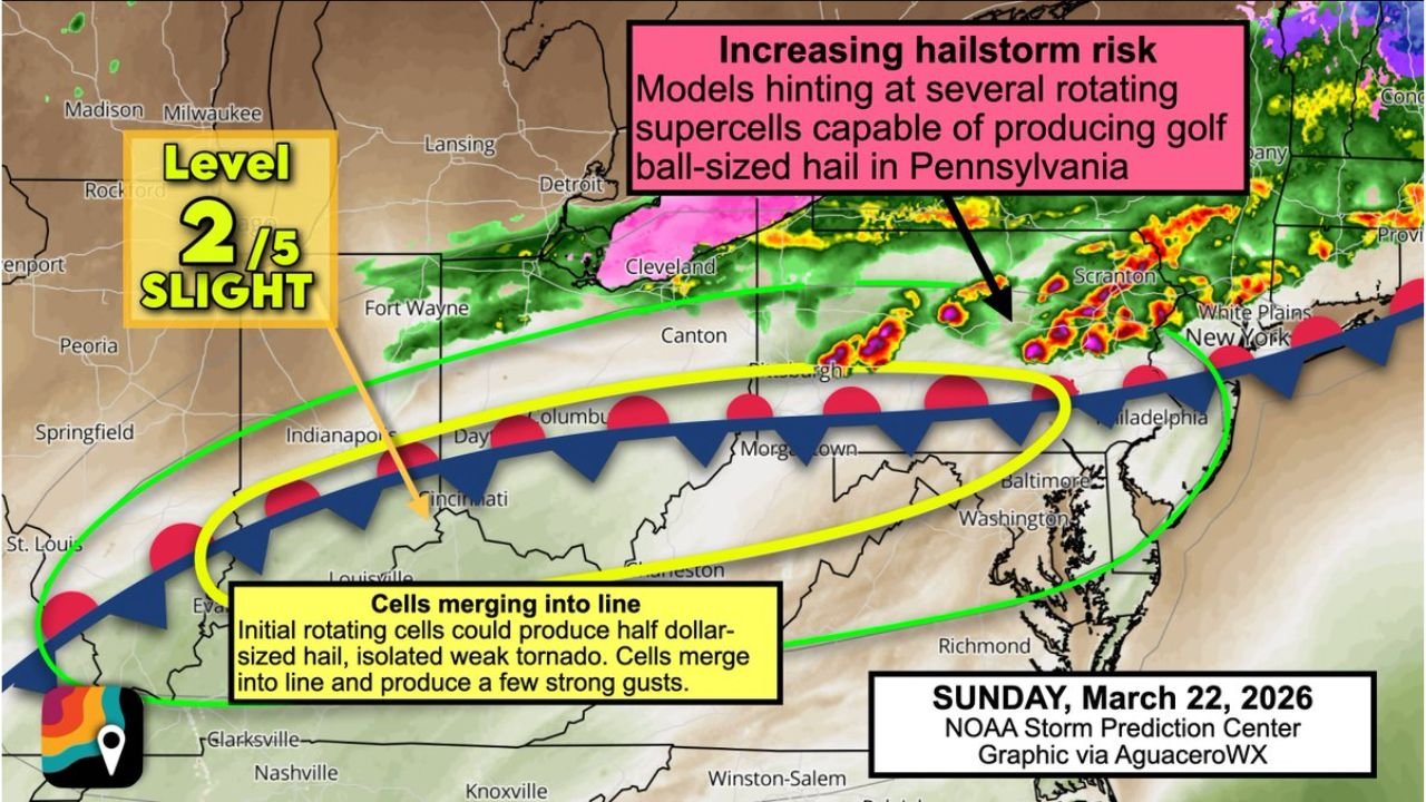
The greatest concern appears to be across Pennsylvania and areas near the Mason-Dixon Line, where atmospheric conditions favor strong, rotating storms capable of producing large hail.
Forecast signals indicate the potential for hail reaching quarter to ping pong ball size, with a low-end risk of even larger stones in isolated storms.
Because these storms are expected to form above a cooler, drier surface layer, they will be considered “elevated storms”, which significantly reduces tornado potential but enhances the risk for large hail production.
Ohio Valley Could See Isolated Tornado Risk Early
Further west, across southern Ohio and southern Indiana, slightly higher surface moisture introduces a different risk profile.
While still limited, there is a low probability of an isolated tornado, particularly during the early stages of storm development when individual cells are more discrete.
Initial storms in this region may also produce half-dollar sized hail before merging into more organized lines.
Storms Expected to Merge Into Damaging Wind Lines
As the evening progresses, storms are forecast to consolidate into lines or clusters, moving southeast across the Appalachians.
At this stage, the primary threat will shift toward strong to locally damaging wind gusts, along with smaller hail up to nickel size.
This transition from isolated rotating storms to linear systems is typical in setups where forcing increases and storms begin interacting with one another.
Level 2 Risk Highlights Scattered Severe Potential
The Storm Prediction Center has outlined a Level 2 out of 5 risk (Slight Risk) across portions of Ohio, Indiana, West Virginia, and Pennsylvania, indicating scattered severe storms are possible.
While not a widespread outbreak, the environment supports enough instability and wind shear to produce several impactful storms, particularly during the late afternoon and evening hours.
What This Means for North Carolina
North Carolina sits just south of the primary risk zone, but storm activity may drift southeastward later in the period.
While severe weather risk is lower locally, residents should remain aware of increasing cloud cover, scattered storms, and occasional gusty winds, especially closer to the mountains.
Timing and Key Impacts to Watch
The most active period is expected Sunday afternoon through Sunday night, when instability and frontal forcing align.
Key hazards include large hail in Pennsylvania, isolated tornado potential in the Ohio Valley, and damaging wind gusts as storms organize into lines.
Stay with CabarrusWeekly.com for real-time updates as this severe weather setup unfolds. If storms develop in your area, report conditions and help keep the CabarrusWeekly.com community informed.