Pennsylvania Severe Storm Risk Expands North and East With Pittsburgh, State College, Harrisburg and Philadelphia in Sunday Impact Zone
PENNSYLVANIA — The threat for strong to severe thunderstorms on Sunday has expanded significantly north and east, now covering a larger portion of the state including major population centers.
Expanded Risk Now Covers Central and Eastern Pennsylvania
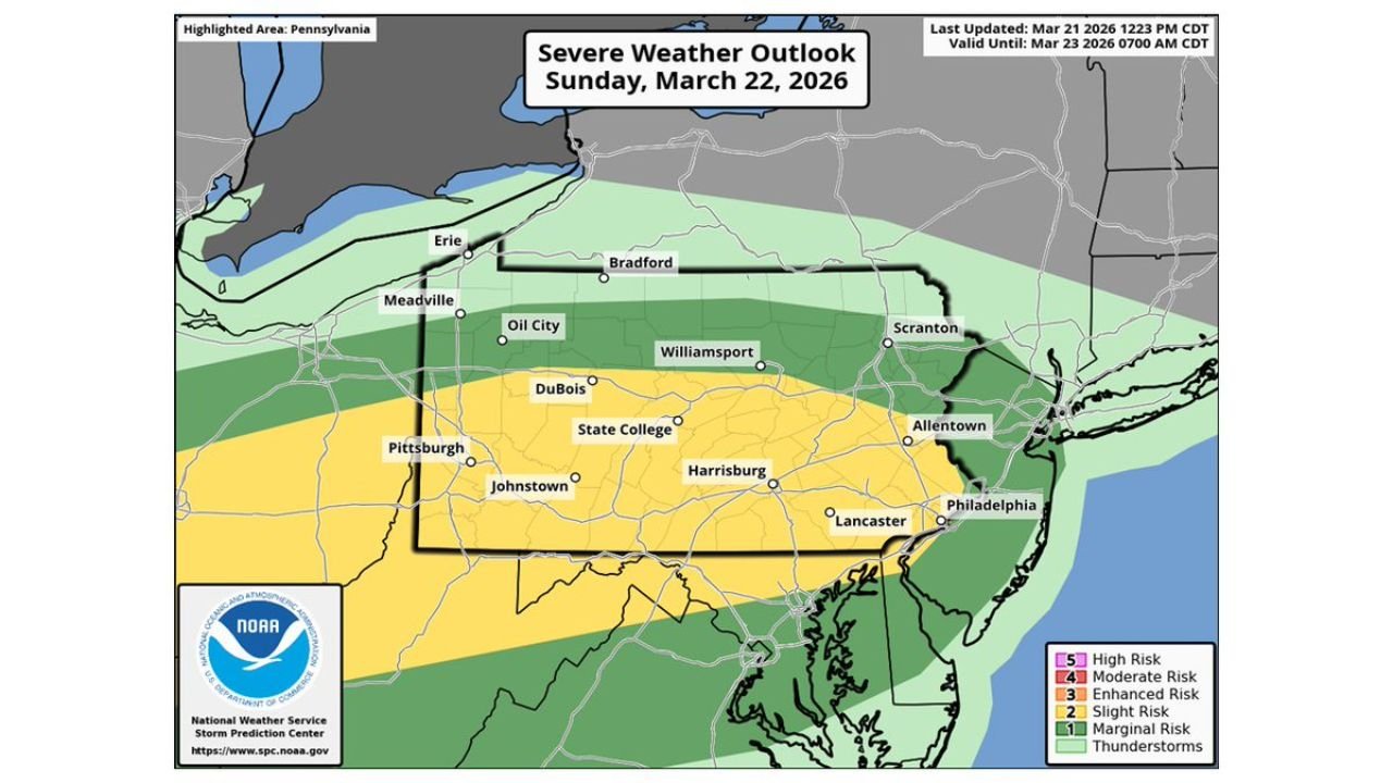
Updated outlook data shows the Slight Risk (Level 2 of 5) zone stretching across much of central Pennsylvania, including Pittsburgh, State College, Harrisburg, and toward Philadelphia.
Areas farther north, including Williamsport and Scranton, remain under a broader marginal risk, where storms are possible but may be less intense.
This expansion indicates increasing confidence that more locations across the state could experience severe weather.
Storm Timing Expected Sunday Afternoon Through Night
The most active period is expected Sunday afternoon into Sunday night, as storms develop and move eastward across the region.
Initial development is likely across western Pennsylvania near Pittsburgh, with storms strengthening as they track into central and eastern parts of the state.
By evening, activity may approach heavily populated corridors, increasing the potential for impacts during higher travel periods.
Primary Threats Include Hail and Damaging Winds
The environment supports strong thunderstorms capable of producing large hail and damaging wind gusts.
While not a widespread outbreak, conditions are favorable for scattered severe storms, particularly within the Slight Risk zone.
Localized impacts such as downed trees, power outages, and brief intense rainfall are possible where storms become stronger.
Northern Areas Face Lower but Not Zero Risk
Northern Pennsylvania remains in a marginal risk zone, meaning storms are expected but with lower overall intensity.
However, even in these areas, isolated storms could still produce gusty winds or small hail, especially if storms intensify briefly.
Residents across the entire state should remain weather aware as conditions evolve.
Why the Risk Area Has Expanded
Meteorologists point to increasing confidence in instability and storm development spreading farther north and east, prompting the expanded outlook.
As atmospheric conditions align, storms are expected to have greater coverage and potential intensity across a wider area than previously forecast.
What This Means Going Into Sunday
Residents across Pennsylvania should prepare for a dynamic weather day, with conditions capable of changing quickly during the afternoon and evening.
Those in the Slight Risk zone should be especially alert for stronger storms capable of producing severe impacts, while others should remain aware of general thunderstorm activity.
Stay with CabarrusWeekly.com for continued updates as this developing severe weather threat unfolds. If storms impact your area, share your conditions with the CabarrusWeekly.com community.