Pennsylvania Snow Clipper and Arctic Front Set to Drive Powerful Winds and Cold Into North Carolina, Virginia, Maryland, and the Northeast This Weekend
PENNSYLVANIA — A Powerful Winter Pattern Takes Shape Across the Eastern U.S. A fast-moving snow clipper system racing across Pennsylvania late Friday is serving as the first signal of a much broader and more dangerous winter setup unfolding across the eastern United States. While the heaviest snow will stay focused north of North Carolina, the same system will tighten the pressure gradient, unleashing strong winds, plunging temperatures, and dangerous wind chills from the Northeast through the Mid-Atlantic and into the Carolinas this weekend.
Forecast guidance shows this clipper quickly exiting the Northeast, but in its wake, arctic air pours south, setting the stage for some of the coldest and windiest conditions of the season.
Snow Timeline and Accumulation Focused on the Northeast
Snow associated with the clipper is expected to develop Friday into early Saturday, primarily impacting Pennsylvania, New York, Connecticut, Massachusetts, and northern New England.
Current projections indicate:
- General snowfall of 1–2 inches across much of interior southern New England and parts of eastern New York.
- Higher totals of 2–5 inches possible in isolated coastal pockets, where mesoscale features enhance snowfall rates.
- Snowfall occurring mainly during daylight hours Saturday, which could still lead to slick roads despite modest totals.
Even light accumulation may cause travel slowdowns, especially where temperatures remain below freezing throughout the event.
Why Some Areas See Freezing Drizzle Instead of Snow
Along the southern edge of the clipper, including parts of the Ohio Valley, Tennessee Valley, and interior Mid-Atlantic, moisture is limited. This creates conditions favorable for freezing drizzle rather than steady snow.
Forecast ice accumulation remains light, generally a thin glaze, but even small amounts can create:
- Slick bridges and overpasses
- Hazardous untreated roads during the Friday morning commute
This freezing drizzle risk does not center on Cabarrus County, but it highlights how sharp the temperature gradient will be across the region.
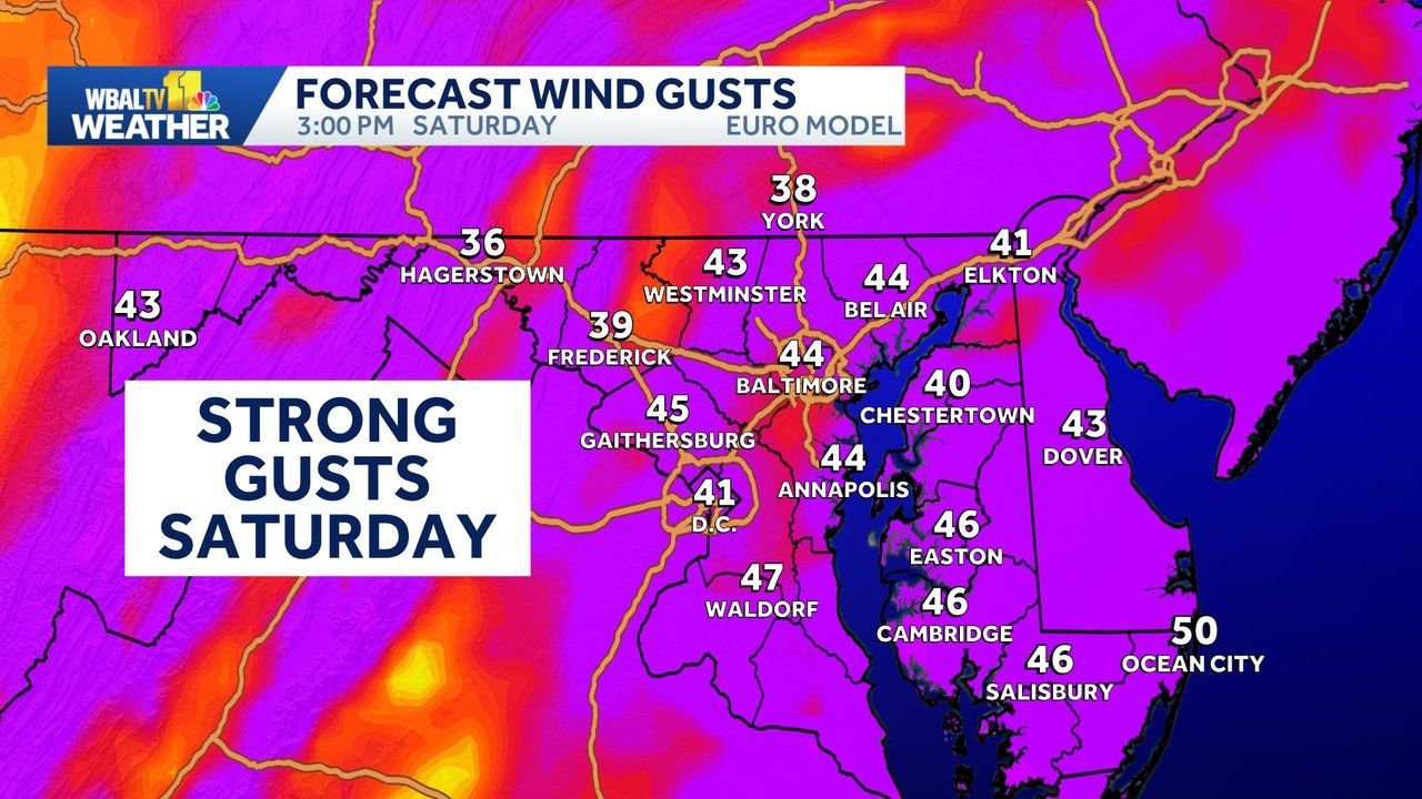
Arctic Front Brings Dangerous Winds and Subzero Wind Chills
Behind the departing clipper, a strong arctic front surges south Friday night into Saturday. Winds rapidly increase as the cold air settles in.
Forecast details show:
- Sustained winds of 25–35 mph
- Wind gusts frequently reaching 40–50 mph, especially Saturday afternoon
- Winds remaining elevated into Saturday night
These winds will dramatically lower wind chill values, particularly across:
- New England
- Upstate New York
- Pennsylvania
- Interior Mid-Atlantic
Some locations in the Northeast could see wind chills between –20°F and –30°F by Sunday morning, values that are rare and potentially dangerous.
What This Means for North Carolina and Cabarrus County
While snow accumulation is not expected in Cabarrus County, North Carolina will not escape the impacts of this system.
For central North Carolina, including Cabarrus County:
- A sharp temperature drop follows the front late Friday night
- Strong northwest winds on Saturday may gust into the 30–40 mph range
- Wind chills will feel well below actual air temperatures, especially early Saturday morning and again Sunday morning
These conditions increase the risk for:
- Isolated power outages
- Downed tree limbs
- Dangerous exposure for anyone outdoors for extended periods
Cold Weather Advisories and Wind Alerts Likely
With the combination of strong winds and bitter cold, forecasters expect a growing number of:
- Wind Advisories
- Cold Weather Advisories
- Possibly High Wind Warnings in the most exposed areas
In the coldest regions of the Northeast, Extreme Cold Warnings may be considered if forecast wind chills verify.
Safety Reminders as the Cold Intensifies
Residents across affected states are urged to:
- Limit outdoor exposure during peak wind and cold
- Dress in layers and protect exposed skin
- Secure loose outdoor items ahead of strong winds
- Check on elderly neighbors and vulnerable individuals
- Prepare for the possibility of brief power outages
Bottom Line
This is not just a quick snow event for Pennsylvania — it is the opening move in a larger arctic outbreak that will impact Pennsylvania, New York, New England, the Mid-Atlantic, and North Carolina through the weekend. While Cabarrus County avoids snow, strong winds and sharply colder air will make this one of the more impactful winter weekends of the season across the eastern U.S.
Stay with CabarrusWeekly.com for continued updates as advisories and warnings are issued and the forecast becomes more refined.