Pennsylvania Snow “Face Lift” Targets Friday Night Into Saturday Morning, With 2–5 Inches Possible From Erie to Scranton
PENNSYLVANIA — A late-week burst of snow is lining up to give the region’s existing snowpack a fresh coating Friday night into Saturday morning, with several forecast maps showing a widespread 1–3 inches and localized higher pockets pushing 3–5 inches across parts of the state.
What the Snowfall Maps Are Signaling
The data provided highlights a “snowpack face lift” setup—meaning this is less of a blockbuster storm and more of a steady, additive snowfall that can still change weekend travel, especially where roads are already snow-covered.
Across the guidance shown, the favored zone for higher totals runs through northwestern and north-central Pennsylvania into nearby parts of southern New York, while amounts ease closer to the Lower Susquehanna Valley and toward southeast Pennsylvania.
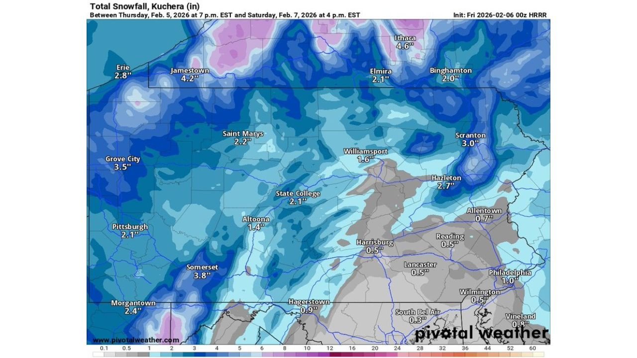
A representative snapshot of totals displayed on the maps includes:
- Jamestown, NY: ~4.2″
- Ithaca, NY: ~4.6″
- Grove City, PA: ~3.5″
- Somerset, PA: ~3.8″
- Erie, PA: ~2.8″
- Pittsburgh, PA: ~2.1″
- State College, PA: ~2.1″
- Scranton, PA: ~3.0″
- Hazleton, PA: ~2.7″
- Altoona, PA: ~1.4″
- Williamsport, PA: ~1.6″
- Allentown, PA: ~0.7″
- Philadelphia, PA: ~1.0″
Timing: When the Best Chance for Accumulating Snow Hits
The maps shown cover a window that stretches from Thursday evening into Saturday afternoon, but the headline message in the data focuses the “refresh” on Friday night into Saturday morning.
That timing matters because overnight snow often:
- Builds accumulation more efficiently on untreated surfaces
- Reduces visibility during the coldest hours
- Creates slick early-morning travel conditions even if totals don’t look extreme
If you’re traveling late Friday or early Saturday, plan for a period where roads can go from “fine” to snow-covered quickly, especially in the higher terrain and in the northwest/western corridor.
Where Snowfall Could Be Highest in Pennsylvania
Based on the plotted totals, the most consistent “better-than-expected” signal appears aimed at:
- Northwest Pennsylvania (near Erie inland and toward Mercer County/Grove City)
- Southwest ridges and higher elevations (Somerset County area)
- Northeast Pennsylvania (Scranton/Hazleton corridor)
These zones show multiple pockets where totals cluster around 2–4 inches, with some nearby higher values just across the border into New York suggesting the northern tier could see a little extra if bands set up the right way.
Lower Totals Near Harrisburg, Lancaster, and the I-95 Corridor
The same data set shows a sharp decrease toward the southeast, with lighter totals displayed around:
- Harrisburg: ~0.5″
- Lancaster: ~0.5″
- Reading: ~0.5″
- Wilmington, DE area: ~0.5″
- South Bel Air, MD area: ~0.3″
Even in the lower-total areas, the bigger story can still be timing + road temperatures. A quick burst at night can coat bridges, ramps, and secondary roads—especially if there’s already snowpack nearby keeping pavement colder.
Why Totals May Shift: Different Models, Same General Idea
The images show multiple snowfall solutions (including high-resolution guidance), and while exact totals vary from panel to panel, they share the same general theme: a broad, light-to-moderate snowfall with localized heavier pockets.
That’s a classic recipe for “map chasing,” where your town might end up:
- Near the top end if a band sits over you for a few hours, or
- Near the low end if the snow comes in lighter/shorter than expected
For practical planning, a reasonable way to view this setup is:
- Most of Pennsylvania: 1–3 inches
- Northwest / higher terrain / parts of the northeast: 2–5 inches in localized pockets
- Lower Susquehanna into far southeast: a coating to around 1 inch, with isolated higher totals if a heavier burst clips the area
What This Means for Roads and Weekend Plans
This kind of event can be deceptively impactful because it falls into the “enough to cause problems” category:
- Visibility reductions during any heavier banding Friday night
- Plowable snow in the 3–5″ pockets
- Refreeze risk if roads get slushy, then temperatures drop again
If you’re in a higher-total corridor, expect snow-covered side roads and slower travel early Saturday. In lighter-total areas, watch for thin, patchy slick spots—especially on bridges and shaded routes.
CabarrusWeekly.com wants to hear from you: did your area get a quick “snowpack refresh” overnight, or did totals come in lower than expected? Share what you’re seeing where you live, and keep following CabarrusWeekly.com for more weather updates.