Pittsburgh Airport Hits Two “Weathergami” Temperature Combos in Back-to-Back Days, a First in Records Since 1875
PITTSBURGH, PENNSYLVANIA — A burst of deep winter cold delivered a rare statistical milestone at Pittsburgh International Airport at the end of January: the site recorded not one, but two “weathergami” temperature combinations on back-to-back days, something that stands out in a dataset stretching back more than a century.
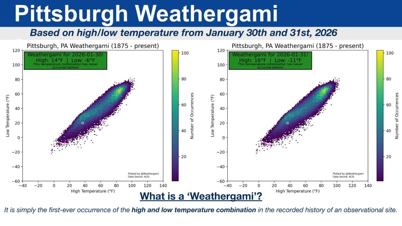
The National Weather Service office in Pittsburgh highlighted that the airport scored a “weathergami” on January 30 and January 31, 2026—a label used when a specific high-temperature and low-temperature pairing has never occurred before in that observation site’s recorded history.
What a “Weathergami” Actually Means
A weathergami is not a heat record or an all-time cold record by itself. Instead, it’s a never-before-seen combination of the day’s high and low temperatures at a particular location.
Think of it like this: Pittsburgh may have experienced similar highs before and similar lows before, but that exact pairing together on the same calendar day is what makes it unique. It’s essentially a “first-time combo” in the climate record.
In this case, the record being referenced is for Pittsburgh, PA (1875–present)—a long observational history that makes any new combination especially notable.
The Two Pittsburgh “Weathergami” Days: Jan. 30 and Jan. 31, 2026
The data shared for Pittsburgh’s late-January cold snap shows two distinct high/low sets that had never been recorded previously at the airport:
- January 30, 2026: High 14°F, Low -6°F
- January 31, 2026: High 16°F, Low -11°F
Those lows are the eye-catcher. Dropping to -6°F and then -11°F on consecutive nights helps explain how unusual the temperature pattern was, even if daytime highs remained in the teens.
Why This Kind of “First-Ever Combination” Can Still Happen
People often assume that after 100+ years of recordkeeping, “everything has already happened.” But weather doesn’t work that way—because temperature outcomes are shaped by a moving mix of variables:
- How quickly Arctic air arrives or departs
- Cloud cover and wind overnight (which can limit or accelerate radiational cooling)
- Snow cover and ground conditions (which can help temperatures crash faster at night)
- Timing of clearing skies after a system passes
- The exact strength and positioning of high pressure
When those ingredients line up just a little differently than they have in the past, you can end up with a new high/low pairing, even without breaking an absolute all-time record.
What Pittsburgh’s “Weathergami” Says About This Winter’s Cold Shots
For the East and parts of the Midwest, winter has produced repeated stretches of below-normal cold, and Pittsburgh’s late-January plunge fits that theme. A high in the teens paired with a subzero low often points to a strong Arctic air mass with enough clearing and calm overnight conditions to let temperatures fall hard.
Two unique combinations in two days also hints at how sharply temperatures can swing in the lower atmosphere during major cold outbreaks—where the daytime recovery is limited, but the nighttime drop can be extreme.
Why WingsPNW Is Watching Stories Like This
Even though Pittsburgh sits far from the Pacific Northwest, events like this matter for a broader reason: they show how winter patterns can set up historic-feeling extremes in one part of the country, while other regions experience a very different season.
For weather watchers in Washington and Oregon, it’s a reminder that U.S. winter impacts aren’t always uniform. A single winter can deliver record-breaking warmth in one region and historic cold signatures in another—sometimes at the same time.
If you’ve seen unusual temperature behavior where you live this season—odd warm spells, sudden freezes, or extremes that feel “out of character”—we want to hear about it. Share your observations and join the conversation at Cabarrusweekly.com.