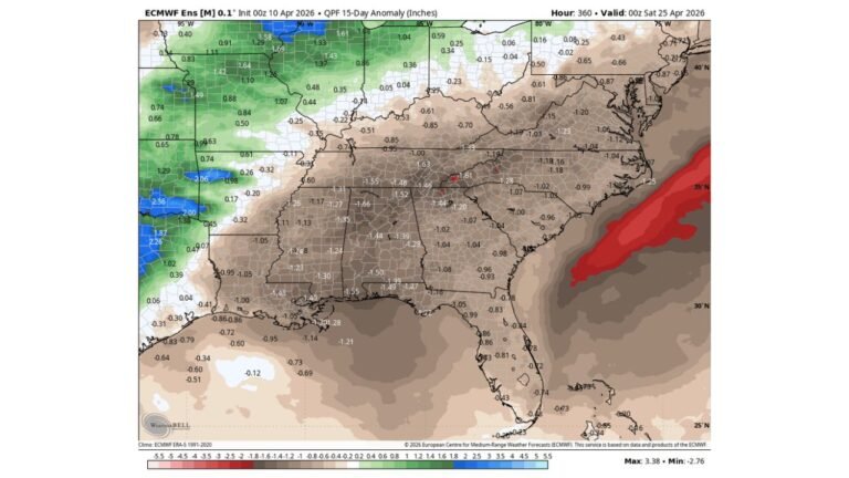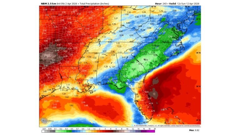
Plains and Midwest Set for Heavy Rain Surge While Southeast Stays Dry as Storm Track Shifts West of Carolinas
UNITED STATES — A sharp weather contrast is developing across the country, with heavy rain expected to drench parts of the Plains and Midwest, while the Southeast, including the Carolinas, remains stuck in a dry pattern with little to no rainfall in sight.
The latest rainfall outlook highlights a clear west-to-east divide, where storm systems continue to track away from the Southeast, leaving drought conditions to worsen.
Heavy Rain Targets Central U.S. Corridor
Forecast data shows a significant band of rainfall setting up from Texas through the central Plains into the Midwest, including:
- North Texas and Oklahoma
- Kansas and Nebraska
- Missouri, Iowa, and parts of Illinois
Within this zone, rainfall totals could reach:
- 1 to 2+ inches in many areas
- Locally higher amounts exceeding 2 inches, especially where storms repeatedly track over the same locations
This setup suggests beneficial rainfall and potential drought relief for parts of the central U.S., though localized flooding cannot be ruled out in heavier pockets.
Storm Track Avoids the Southeast
While central states see repeated storm chances, the Southeast remains largely shut out of meaningful rainfall, including:
- North Carolina
- South Carolina
- Georgia
- Alabama
High pressure is expected to dominate the region, forcing storm systems to stay farther west.
As a result:
- Rainfall totals remain near zero or very minimal
- Any isolated showers will be brief and ineffective for drought relief
Carolinas Continue to Miss Out on Rain
For the Carolinas in particular, the pattern is becoming increasingly concerning.
Despite being in a time of year typically associated with spring showers, the forecast shows:
- No consistent rain chances over the next several days
- Continued dry conditions as storm systems pass well to the west
This aligns with the growing concern that April may not deliver its usual rainfall benefits this year.
Why the Pattern Is Locked In
The key driver behind this setup is a persistent high-pressure system over the Southeast, which:
- Blocks moisture from reaching the region
- Redirects storm systems into the Plains and Midwest
- Reinforces a dry and stable air mass
Meanwhile, active storm energy continues to ride along the western edge of this high, fueling repeated rain events farther west.
Impact: Relief for Some, Growing Concern for Others
This evolving pattern creates a split-impact scenario across the country:
Central U.S. (Positive Impact)
- Improved soil moisture
- Drought relief potential
- Increased river and reservoir levels
Southeast (Negative Impact)
- Worsening drought conditions
- Increased wildfire risk
- Rising concern for agriculture and water supply
What to Expect Going Forward
The outlook suggests this pattern may persist in the near term, meaning:
- The Plains and Midwest could continue seeing active storm systems
- The Southeast may remain dry longer than usual, delaying any meaningful drought relief
At this time, there are no strong signals of a pattern shift that would bring widespread rain back to the Carolinas.
Final Outlook
While parts of the country finally see much-needed rainfall, the Southeast is heading in the opposite direction, with dry conditions expected to linger and potentially worsen.
This growing imbalance highlights a concerning trend as spring progresses, especially for regions already dealing with limited rainfall.
Stay with CabarrusWeekly.com for ongoing updates as this developing weather pattern continues to unfold.