Plains, Midwest and Southeast Face Four Consecutive Days of Severe Weather Saturday Through Tuesday With Storms Targeting Oklahoma, Kansas, Iowa, Arkansas and Tennessee April 4-8
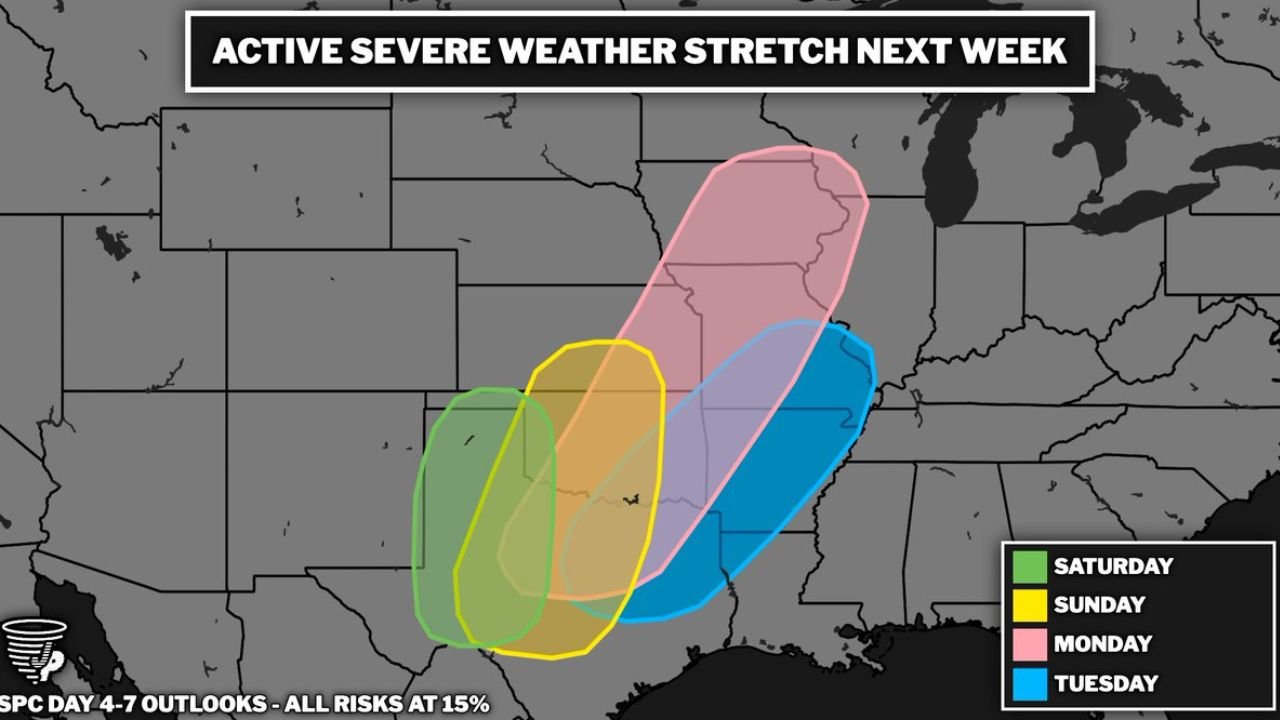
UNITED STATES — An active and sustained severe weather stretch is taking shape across the central United States, set to kick off this weekend and run through next week. The Storm Prediction Center has issued 15% severe weather probabilities — equivalent to a Slight Risk Level 2 of 5 — for four consecutive days from Saturday, April 4 through Tuesday, April 8, 2026.
This is not four isolated storm days. It is a continuous pattern that will progressively shift from the southern Plains this weekend into the Midwest on Monday and the Southeast by Tuesday — affecting tens of millions of Americans across a large and overlapping corridor.
Four Days, Four Shifting Risk Zones
The severe weather threat moves eastward and northward with each passing day:
Saturday, April 4 — Southern Plains
- Western Oklahoma
- Texas Panhandle
- Eastern New Mexico
Sunday, April 5 — Central Plains
- Kansas
- Central Oklahoma
- Northern Texas
Monday, April 6 — Largest Zone — Plains Into Midwest
- Iowa
- Missouri
- Illinois
- Kansas
- Oklahoma
- Arkansas
Tuesday, April 8 — Southeast Corridor
- Arkansas
- Tennessee
- Mississippi
- Alabama
- Louisiana
- Missouri
Why Saturday Starts the Concern
Saturday opens the stretch across the southern Plains with classic dryline severe weather ingredients already in place. Gulf moisture is building, upper-level energy is arriving from the west, and a dryline positioned across the Texas Panhandle will be the primary trigger for afternoon and evening storm development.
Communities across western Oklahoma, Amarillo, and Lubbock face the highest risk Saturday as storms fire along the dryline through the late afternoon hours.
Monday Stands Out as the Biggest Day
Of the four days, Monday carries the largest and most widespread risk zone — expanding significantly northward into Iowa, Missouri, and Illinois while maintaining coverage across Kansas, Oklahoma, and Arkansas.
By Monday the upper-level system driving this entire pattern has deepened enough to extend the severe weather threat well into the Corn Belt. Residents across Des Moines, Kansas City, St. Louis, and Chicago who may have avoided the worst of the weekend storms are directly in Monday’s path.
Tuesday Brings the Southeast Into the Crosshairs
The pattern concludes Tuesday with the threat shifting into Arkansas, Tennessee, Mississippi, and Alabama. By this point in the stretch, significant rainfall will have already fallen across the region from earlier storm days — meaning flash flooding and river flooding become elevated concerns on top of the severe thunderstorm and tornado threat Tuesday.
The trailing end of multi-day severe weather stretches can be among the most dangerous — atmospheric moisture and instability reach their maximum depth by the final day of the pattern.
Primary Hazards Each Day
Across all four days the primary threats include:
- Damaging wind gusts of 58 mph or greater
- Large hail of one inch or larger
- Tornadoes, especially where discrete supercells can organize
- Flash flooding from cumulative heavy rainfall across overlapping zones
Part of a Larger and Historic Pattern
This four-day stretch does not arrive in isolation. It follows one of the most active severe weather weeks in recent memory across the Plains and Midwest — extending a pattern that has already produced multiple tornado outbreaks, significant hail events, and widespread damaging winds across the same general corridor.
Each new wave of storms carries increasing moisture from the Gulf, compounding rainfall totals and raising the flood risk with every passing day across the most heavily impacted zones.
Preparation Urged Across All Impacted States
With major cities and densely populated areas directly in the risk zone across all four days, early awareness is critical.
Residents across Oklahoma, Kansas, Texas, Iowa, Missouri, Illinois, Arkansas, Tennessee, Mississippi, and Alabama should:
- Finalize tornado shelter plans before Saturday morning
- Assemble a 72-hour emergency kit — water, food, medications, backup power, and a weather radio
- Know your flood evacuation route in addition to your tornado shelter location
- Keep alert systems active through the entire four-day window
- Monitor updated forecasts daily as each individual storm day comes into closer range
Cabarrus Weekly Perspective
When the Storm Prediction Center issues four consecutive days of organized severe weather risk this far in advance, it is a signal that the atmosphere is aligning for a sustained and significant pattern — not a series of random storm days.
Monday already stands out as the day to watch most closely given its expanded geographic footprint reaching into the Midwest. But Tuesday’s Southeast threat deserves equal attention — the combination of cumulative moisture, rising river levels, and fresh severe weather ingredients by the end of the week creates a potentially dangerous multi-hazard environment across Arkansas, Tennessee, and the Deep South.
Early preparation across every state in this four-day corridor is not an overreaction. It is the right response to one of the most sustained severe weather stretches of the spring season.
Stay ahead of dangerous weather before it reaches your door. Visit cabarrusweekly.com for daily severe weather coverage, storm alerts, and forecast updates from across the United States — because knowing early is the difference that matters.