Plains Severe Weather Threat Builds February 17–19 as Strong Wind Shear and Storm Energy Signal Potential Tornado and Damaging Wind Setup
CENTRAL UNITED STATES — A developing storm pattern later this month is drawing growing attention from meteorologists as forecast signals increasingly support a multi-day severe weather threat across the Plains from February 17 through February 19, with conditions favoring organized storms capable of damaging winds and tornadoes.
Strong Wind Shear and Hodographs Signal Organized Storm Potential
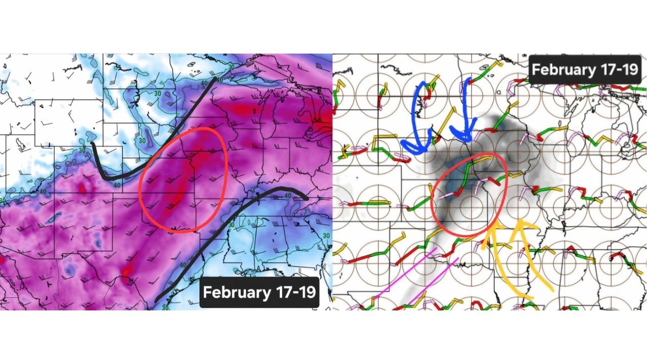
Forecast guidance from both European and GFS-based datasets shows robust mid- and upper-level wind shear developing across portions of the central and southern Plains during the February 17–19 timeframe. Wind fields strengthen significantly with height, producing curved hodographs that are supportive of rotating thunderstorms if storms are able to initiate.
This type of wind profile is commonly associated with supercell storm modes, particularly when surface-based storms can tap into the stronger winds aloft. Several model depictions highlight a broad corridor of enhanced shear stretching from the southern Plains into parts of the central Plains, suggesting the environment could support sustained, organized convection rather than short-lived storms.
Elevated Storm-Relative Helicity Raises Tornado Concerns
In addition to strong shear, forecast maps show increasing storm-relative helicity (SRH) across the same region, an important ingredient for tornado development. SRH values appear most favorable across areas where low-level winds are forecast to back and strengthen ahead of an approaching system.
The overlap of strong shear and enhanced helicity increases the potential for storms to acquire and maintain rotation. While it is still too early to determine the exact magnitude of the tornado threat, the signal is strong enough to warrant close monitoring as the event approaches.
Upper-Level Support and Energy Align Over the Plains
Upper-air pattern analysis indicates a large-scale trough moving into the western and central United States, helping to increase lift and deepen the wind field over the Plains. Forecast energy fields suggest above-normal atmospheric energy available for storm development, especially during peak heating periods.
This setup favors widespread thunderstorm coverage rather than isolated activity, provided sufficient moisture return occurs from the Gulf of Mexico. The combination of lift, shear, and instability is a classic precursor to severe weather outbreaks in the Plains during late winter and early spring.
Timing and Geographic Focus Still Being Refined
At this range, forecast confidence is highest in the February 17–19 window, but the precise placement of the highest-risk corridor remains subject to change. Current signals favor parts of the southern and central Plains, though adjustments north or south are possible depending on storm track evolution and moisture quality.
Meteorologists emphasize that trends over the next several days will be critical, particularly regarding surface moisture, storm initiation timing, and how quickly instability can build ahead of the system.
What to Watch as the Pattern Evolves
As this setup comes into clearer focus, forecasters will be watching for signs of improving moisture return, stronger surface lows, and sharper frontal boundaries, all of which could elevate the severe threat further. Residents across the Plains are encouraged to stay weather-aware, especially if forecast confidence continues to increase closer to mid-February.
If you live in the Plains and have noticed changing weather patterns or are preparing for potential severe weather, we’d like to hear from you. Share your local conditions and stay updated with the latest forecasts at CabarrusWeekly.com.