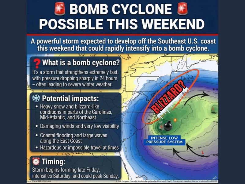
Potential Bomb Cyclone Raises Blizzard, Wind, and Coastal Flooding Concerns From the Carolinas to the Northeast This Weekend
UNITED STATES — Forecasters are closely monitoring a powerful coastal storm expected to develop off the Southeast U.S. coast this weekend, with growing concern that it could rapidly intensify into a bomb cyclone, a scenario capable of producing blizzard-like snowfall, damaging winds, and coastal flooding across a large portion of the East Coast.
What a Bomb Cyclone Means for the East Coast
A bomb cyclone is defined as a storm system that strengthens extremely fast, with surface pressure dropping sharply within a 24-hour period. When this occurs during winter, the result is often severe cold-season weather, including intense snowfall rates, dangerous winds, and rapidly deteriorating travel conditions.
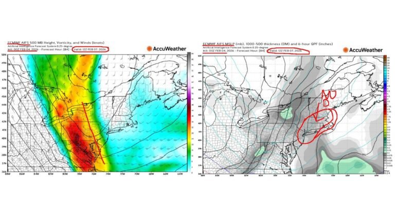
Current projections suggest this storm may undergo that type of rapid intensification as it organizes offshore and begins tracking northward.
Heavy Snow Possible From the Carolinas to the Mid-Atlantic
As the system strengthens, heavy snow and blizzard-like conditions are possible across parts of the Carolinas, Mid-Atlantic, and Northeast. Inland areas stand the highest risk for significant snowfall as cold air remains entrenched away from the immediate coastline.
Snowfall rates could become intense at times, especially as the storm deepens and bands of heavier precipitation rotate inland. Where strong winds overlap with heavy snow, near-whiteout conditions may develop.
Dangerous Winds and Very Low Visibility Expected
One of the biggest threats with this system is wind. As pressure rapidly falls, damaging winds are likely, particularly near the coast and within stronger snow bands. Even where snow totals are lower, very low visibility could make travel hazardous or impossible for several hours.
Blowing and drifting snow may continue even after snowfall rates begin to ease, extending impacts well beyond the peak of the storm.
Coastal Flooding and Large Waves Along the East Coast
Strong onshore winds combined with a deepening low-pressure system raise concerns for coastal flooding and large, battering waves along the East Coast. Vulnerable coastal communities could experience water inundation, beach erosion, and dangerous marine conditions.
These impacts could stretch across a broad area, depending on the storm’s exact track and intensity.
Timing: Rapid Changes Expected Through the Weekend
Forecast guidance indicates the storm may begin organizing late Friday, intensify Saturday, and potentially reach peak strength on Sunday. This timeline leaves room for significant forecast adjustments, as even small changes in track or speed could dramatically alter snowfall placement and wind impacts.
Meteorologists emphasize that confidence will improve as the storm draws closer, but preparation should begin early given the range of possible outcomes.
Residents along the East Coast are urged to stay weather-aware, review travel plans, and prepare for rapidly changing conditions. If you experience snow, strong winds, or coastal flooding this weekend, share what you’re seeing and stay connected with continuing coverage at CabarrusWeekly.com.