Powerful 984 mb Low Could Unleash Severe Storms in the South and Heavy Snow from Iowa to Michigan on Sunday
UNITED STATES — A rapidly intensifying storm system is poised to deliver a dramatic weather contrast on Sunday, with severe thunderstorms erupting across the South while heavy snow wraps around the system from the Midwest into the Great Lakes.
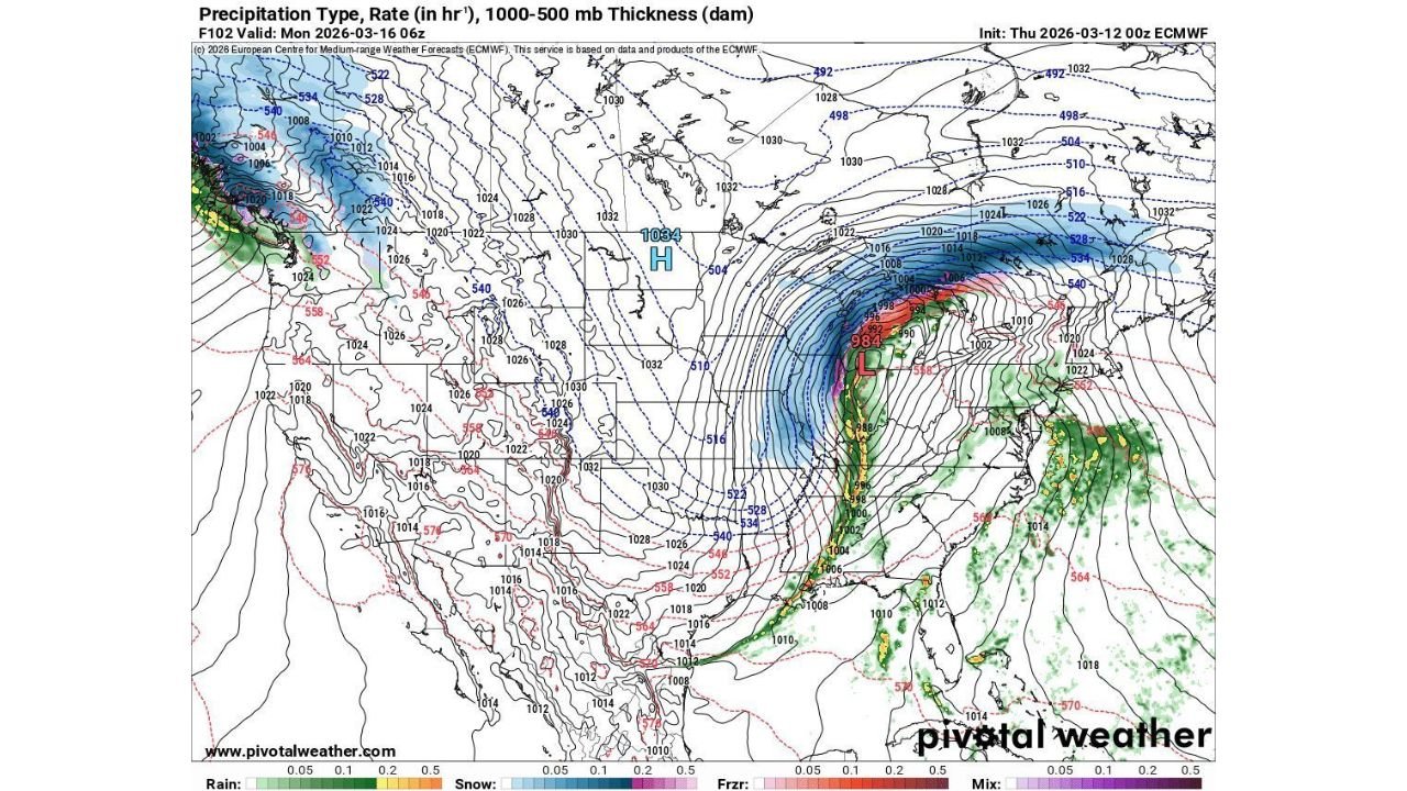
Forecast guidance shows a deep low pressure center near 984 mb tracking into the Upper Midwest by late Sunday night, creating a powerful and dynamic setup across much of the eastern half of the country.
Explosive Storm Development Across the Midwest
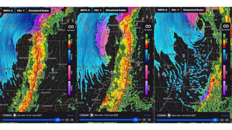
The projected surface map shows tightly packed pressure lines around the deepening low, indicating strong winds and a rapidly strengthening system.
As the storm lifts north:
- Heavy snow develops on the northwest side of the low
- A narrow but intense line of severe thunderstorms forms along the cold front
- Widespread rain spreads across the Southeast and Mid-Atlantic
The tight pressure gradient suggests windy conditions will accompany both the snow and severe weather zones.
Heavy Snow From Iowa Through Wisconsin Into Michigan
On the cold side of the system, a broad swath of accumulating snow is expected from:
- Eastern Nebraska
- Iowa
- Southern and central Minnesota
- Wisconsin
- Northern Illinois
- Michigan
The heaviest snowfall appears focused from eastern Iowa into Wisconsin and Lower Michigan, where dynamic cooling and strong lift may support intense snow bands.
If the storm deepens as projected, snowfall rates could become heavy at times Sunday night into early Monday.
Severe Weather Risk Across the South
Meanwhile, the warm sector of the storm features a classic severe weather setup.
A sharp cold front extends from the Midwest southward through:
- Arkansas
- Mississippi
- Alabama
- Tennessee
- Louisiana
- Parts of Texas
This corridor is primed for strong thunderstorms as warm, moist air surges northward ahead of the system.
Severe weather potential may include:
- Damaging wind gusts
- Large hail
- Possible tornadoes
The strong dynamics associated with the deep low increase concern for organized severe storms along the frontal boundary.
Heavy Rain Along the East Coast
Farther east, widespread rain is projected from:
- Georgia
- The Carolinas
- Virginia
- The Mid-Atlantic
While not as intense as the severe zone to the west, periods of steady rainfall could still cause localized travel disruptions.
Why This System Is So Intense
The map indicates strong upper-level energy diving into the central United States, interacting with warm Gulf moisture.
This combination fuels:
- Rapid surface low intensification
- Strong wind fields
- Sharp temperature contrasts
- Multiple precipitation types within the same system
Such setups are classic for high-impact March storms capable of delivering both severe weather and heavy snow within the same 24-hour period.
Bottom Line
Sunday’s system could bring a rare and dramatic split: severe thunderstorms in the South and heavy snow across the Midwest and Great Lakes — all tied to a deepening low pressure center pushing northeast.
From Iowa and Wisconsin to Michigan, accumulating snow may create slick conditions, while areas from Arkansas to Alabama could contend with strong to severe storms.
CabarrusWeekly.com will continue tracking this evolving storm system and provide updates as the forecast becomes clearer.