Powerful East Coast Winter Storm Targets the Carolinas and Virginia With Heavy Snow, Damaging Winds, and Coastal Flooding Risk
UNITED STATES — A rapidly intensifying coastal winter storm is expected to develop off the Carolinas this weekend, setting the stage for heavy snowfall, powerful winds, and coastal flooding from the Southeast through the Mid-Atlantic and into parts of the Northeast.
Coastal Low Expected to Rapidly Intensify Off the Carolinas
Forecast guidance shows a coastal low forming near the Carolinas on Saturday, with strong signals that the system could rapidly strengthen, dropping more than 24 millibars in 24 hours. This type of intensification places the storm in the category of a bombing coastal cyclone, capable of producing extreme winter impacts over a large area.
As the low strengthens, snowfall rates of 1 to 2 inches per hour are possible across portions of North Carolina, South Carolina, and Virginia, especially where cold air remains locked in place inland.
Carolinas Face Significant Snowfall With Sharp Inland Gradient
Snowfall forecasts show a clear inland-versus-coastal divide across the Carolinas.
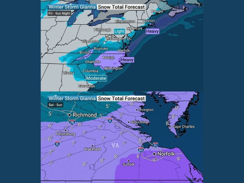
In central and western North Carolina, including areas near Charlotte, Greensboro, and Raleigh, snow totals are projected in the 5 to 8 inch range, with some localized pockets potentially higher.
Parts of eastern North Carolina, including areas closer to Wilmington, may see 8 to 12 inches, depending on how close the storm tracks to the coast. Farther south into South Carolina, totals generally range from 3 to 6 inches, with lighter accumulations closer to the immediate coast where mixing may occur.
Virginia and Mid-Atlantic Could See Widespread Heavy Snow
As the storm tracks north and east through Sunday, Virginia becomes a primary concern zone. Forecast maps indicate 6 to 9 inches of snow across much of eastern and central Virginia, including areas near Richmond, Norfolk, Suffolk, and Gloucester.
Snow totals will depend heavily on the storm’s proximity to the coastline. A slightly offshore track favors more snow, while a closer coastal path introduces mixing or rain near the shore. A narrow corridor near 40°N and 70°W represents a potential “sweet spot” that could maximize snowfall farther north if the storm aligns correctly.
Northeast Impacts Depend on Exact Storm Track
Farther north into Maryland, Delaware, New Jersey, and southern New England, snowfall amounts remain more uncertain. Forecast guidance currently shows moderate snowfall inland with lighter amounts closer to the coast, but even subtle track shifts could significantly change totals.
Areas near New York City, Long Island, and coastal New England remain on the edge between snow and mixed precipitation, making this a high-uncertainty zone to monitor closely.
Wind and Coastal Flooding May Become a Major Hazard
In addition to snow, wind will be a major impact. As the low intensifies, wind gusts could approach hurricane force near the coast, with sustained winds remaining lower but still dangerous.
These winds are expected to cause blowing and drifting snow, leading to very poor visibility and potentially hazardous travel conditions. Along the coast, strong onshore flow may trigger coastal flooding, stretching from the Outer Banks of North Carolina northward toward Maine.
Why This Storm Demands Close Monitoring
Forecasters stress that small track adjustments could dramatically alter snowfall totals, precipitation type, and wind impacts. This makes the storm particularly challenging and reinforces why context and expert analysis matter more than simple weather app summaries.
Additional refinements to snowfall maps and wind forecasts are expected as the storm approaches.
If you’re in North Carolina or tracking this storm along the East Coast, share what conditions look like where you are. Stay tuned for continued updates and in-depth winter weather coverage at CabarrusWeekly.com.