Powerful Northeast Blizzard Unleashes 2–3 Inch Per Hour Snowfall Rates From New Jersey to Massachusetts as Outages Top 250,000
NORTHEAST UNITED STATES — A powerful Monday morning blizzard is hammering the Northeast with very heavy, wet snow, intense wind gusts, and rapidly increasing power outages, as more than 250,000 customers are already reported without electricity.
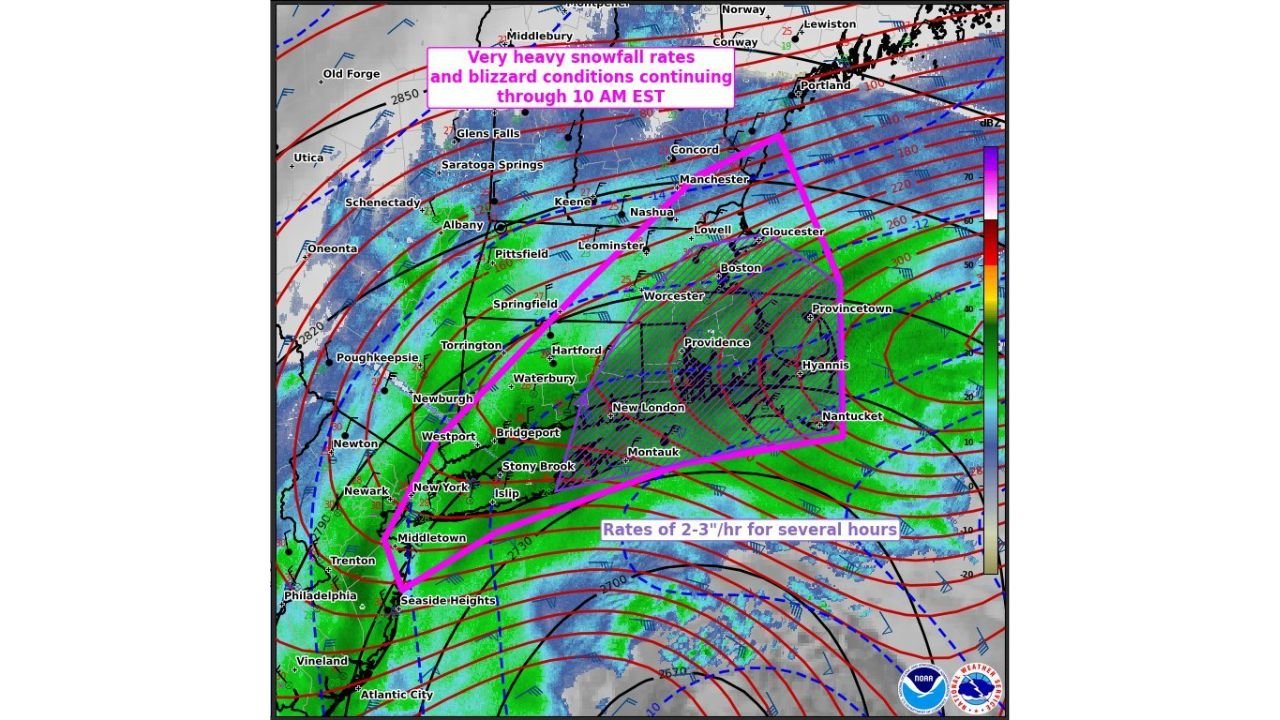
According to the latest mesoscale discussion from the Storm Prediction Center, blizzard conditions are ongoing and expected to continue through at least 10 AM EST, with snowfall rates reaching 2 to 3 inches per hour for several consecutive hours in the hardest-hit corridor.
Blizzard Core Targets Major Population Centers
The most intense snowfall band stretches from parts of New Jersey and southeastern New York through Connecticut, Rhode Island, and eastern Massachusetts, including:
- Middletown, NJ
- New York City
- Islip and Long Island
- Bridgeport and Hartford, CT
- Providence, RI
- Boston, Worcester, and Gloucester, MA
- Nantucket and Provincetown
This zone is highlighted as the area experiencing the heaviest snowfall rates combined with strong winds — a dangerous mix that meets blizzard criteria.
Visibility in some locations is reportedly near zero during peak bursts.
Snowfall Rates of 2–3 Inches Per Hour
Meteorological analysis shows strong frontogenesis and powerful mid-level winds enhancing lift across southern New England and the coastal Mid-Atlantic.
That setup is producing:
- Intense, banded snowfall
- Heavy, wet snow accumulation
- Rapid snow-covered roadways
- Strain on trees and power lines
With snow falling at 2 to 3 inches per hour in places, totals can climb quickly within a short time frame.
Winds, Coastal Impacts, and Rising Outages
In addition to the snowfall, strong winds are contributing to:
- Blowing and drifting snow
- Dangerous travel conditions
- Large coastal waves
- Increasing power outages
With heavy wet snow clinging to branches and lines, the outage count has already surpassed 250,000 customers and is expected to climb as the storm continues.
Coastal communities from Seaside Heights, NJ, to Cape Cod and Nantucket, MA, are also contending with rough surf and wind-driven impacts.
Conditions Continue Through Late Morning
The Storm Prediction Center notes that very heavy snowfall rates and blizzard conditions will persist through at least mid-morning, especially across eastern Massachusetts and Rhode Island.
Communities farther inland, including Albany, Springfield, and Pittsfield, are also experiencing significant snowfall, though the most intense coastal banding remains focused closer to the Atlantic shoreline.
Travel across much of the region is strongly discouraged.
What This Means Beyond the Northeast
While this storm is centered hundreds of miles from North Carolina, its scale and intensity highlight the volatility of late-winter systems along the East Coast.
Residents in the Carolinas often monitor these systems closely, as similar setups can track farther south in different scenarios.
For continued updates on major weather events across the country, stay connected with CabarrusWeekly.com for timely coverage and forecast analysis.