Powerful Plains-to-Ohio Valley Storm Thursday Could Trigger Severe Weather in Kentucky and Tennessee While Heavy Snow Slams Iowa and Illinois
CENTRAL PLAINS AND OHIO VALLEY — A large and dynamic storm system is projected to organize Thursday, tracking from the Central Plains into the Ohio Valley and bringing a sharp divide between severe thunderstorms to the south and heavy snow across portions of the Midwest.
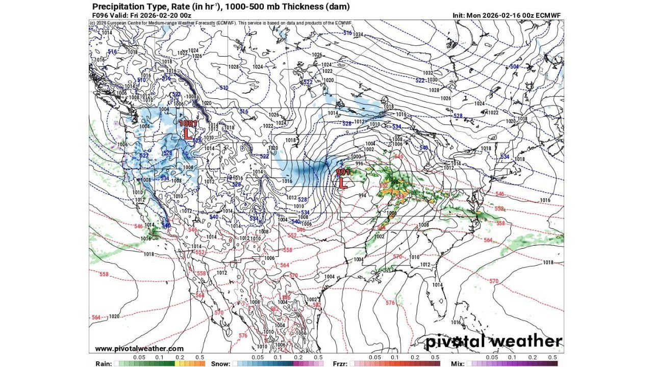
Forecast data indicates a strengthening surface low deepening to around 991 mb over the Mid-Mississippi Valley, signaling a potent system capable of producing widespread impacts.
Deepening Low Pressure Over the Mid-Mississippi Valley
Model guidance shows the storm consolidating over Missouri and Illinois before lifting northeast toward the Ohio Valley. Tight pressure gradients around the 991 mb low center suggest strong winds wrapping around the system, enhancing lift and intensifying precipitation bands.
North and northwest of the low track, colder air is firmly entrenched. Thickness values support accumulating snow from parts of Iowa into northern Illinois and possibly southern Wisconsin, where steady snow bands appear likely.
Snowfall rates could become moderate to heavy at times in the deformation zone northwest of the low center.
Severe Weather Risk Across the Ohio Valley and Tennessee Valley
South and southeast of the low, warmer air surges northward into Kentucky, Tennessee, southern Indiana and parts of Ohio. This setup places the Ohio Valley in a favorable zone for strong to severe thunderstorms, especially along and ahead of the advancing cold front.
Precipitation type projections show a solid rain and thunderstorm shield extending eastward from Missouri through Kentucky and into West Virginia and western Pennsylvania. With strong upper-level dynamics and increasing instability, damaging wind gusts and isolated severe storms cannot be ruled out.
The sharp thermal gradient across the system highlights the classic late-winter clash between lingering cold air in the Midwest and springlike warmth surging north from the Gulf.
Heavy Snow on the Cold Side of the System
As the low strengthens, wraparound moisture feeds into colder air across portions of Iowa, northern Missouri, and northern Illinois, where snow bands may intensify.
The deformation band northwest of the low track often produces the heaviest snowfall rates in systems of this nature. Accumulations will depend on the exact storm path, but guidance clearly supports a measurable snow event in these areas.
Wind-driven snow could also reduce visibility in heavier bursts, particularly if pressure falls deepen further than currently projected.
A High-Impact System With Multiple Hazards
This storm carries multiple threats depending on location. Residents north of the low track should prepare for snow and gusty winds, while communities south and east of the center face the potential for strong thunderstorms and locally heavy rainfall.
The Ohio Valley corridor, including Kentucky and southern Indiana, appears especially vulnerable to the severe weather component as warm air overruns the region.
With a deep surface low, strong upper-level energy and a tight temperature gradient all in place, Thursday’s storm is shaping up to be one of the more significant systems of the week across the Central Plains and Ohio Valley.
If you experience heavy snow, strong winds or thunderstorms as this system moves through, share your reports and photos with us at CabarrusWeekly.com. Your local updates help us track developing conditions in real time.