Powerful Storm Setup Signals Next Week Severe Weather Surge From Texas Through Mississippi Valley Into Midwest With Widespread Instability Building
UNITED STATES — A large-scale and potentially impactful severe weather pattern is beginning to take shape for next week, with conditions aligning for widespread storm development across the central and eastern United States.
Weekend Storms Act as Setup for Larger System
Initial storm activity over the weekend is expected to act as a precursor to a more significant severe weather event next week.
These early storms will help establish a favorable environment, allowing moisture and instability to build ahead of a stronger system expected to move into the region.
Strong Upper-Level Winds Align With Moisture-Rich Air Mass
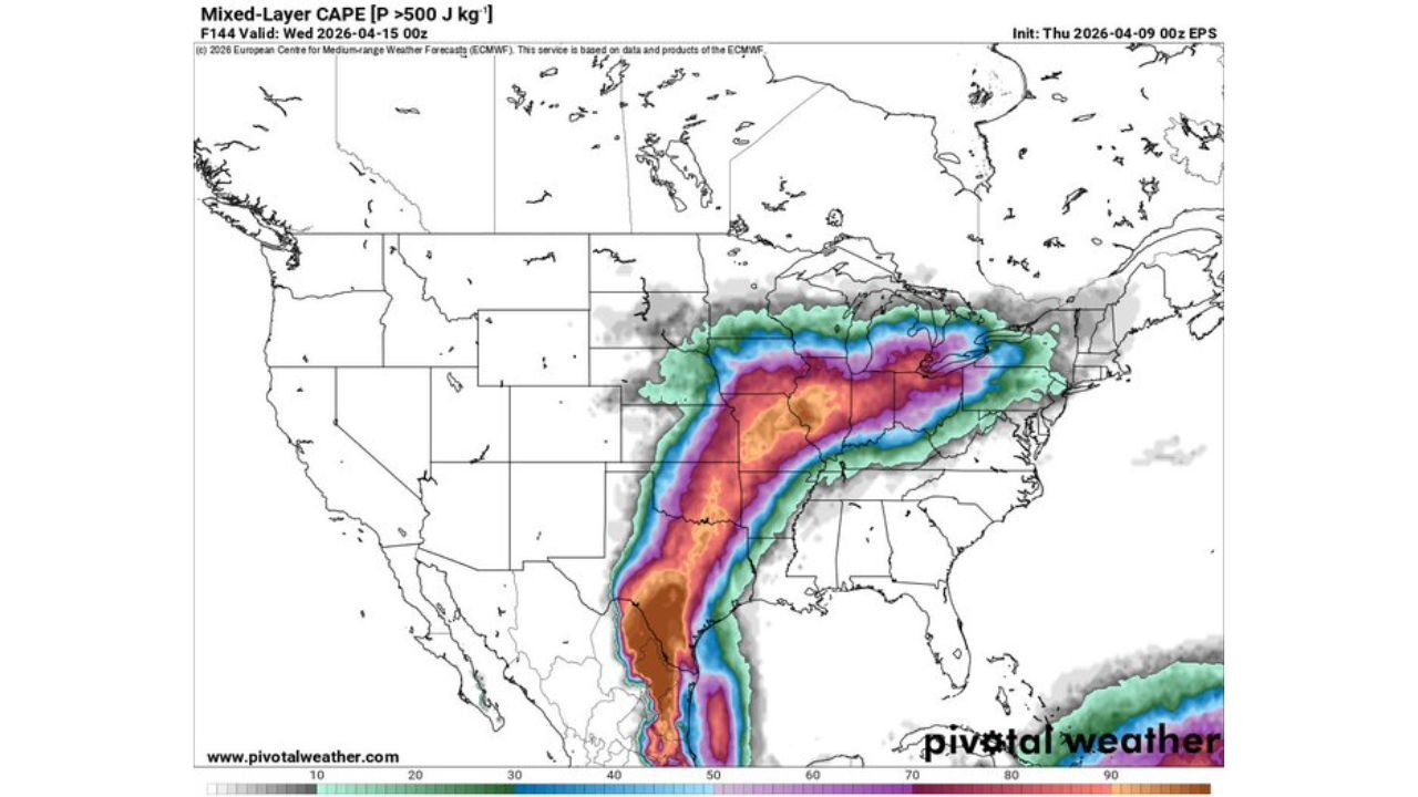
Forecast data shows a powerful upper-level jet stream extending from the Southern Plains into the Midwest, providing strong wind energy necessary for organized storms.
At the same time, a deep, moisture-rich air mass will surge northward from the Gulf of Mexico, overlapping with this upper-level flow.
This combination is a classic setup for organized severe thunderstorms, including the potential for supercells and larger storm systems.
Expanding Instability From Texas to Midwest and Great Lakes
Instability is expected to increase significantly across a broad corridor stretching from Texas through the Mississippi Valley and into the Midwest and Great Lakes.
This zone of instability, combined with strong wind shear, will support robust thunderstorm development capable of producing severe weather over a wide area.
Ingredients Coming Together for Widespread Severe Weather
The overlap of key ingredients — moisture, instability, and strong wind dynamics — suggests the potential for large-scale storm organization rather than isolated events.
This setup raises concerns for multiple rounds of severe weather, potentially impacting several states over consecutive days.
Timing Focus: Next Week Into Tuesday and Beyond
The most significant period appears to be early to mid next week, particularly around Tuesday, when atmospheric conditions are expected to peak.
Storms developing during this time could become more widespread and intense, especially as the system interacts with an already primed environment.
What This Means Moving Forward
This evolving pattern indicates a higher-end severe weather potential across a large portion of the country, especially from the Southern Plains into the Midwest.
While specific details will become clearer in the coming days, the current setup strongly suggests that next week could bring some of the most active severe weather conditions of the period.
Residents across Texas, the Mississippi Valley, and the Midwest should stay alert for updates as this system develops.
Stay with CabarrusWeekly.com for continued coverage, and share what conditions you are seeing in your area as this developing weather pattern unfolds.