Powerful Storm System Triggers Level 3 Severe Risk in Indiana With Threat of Strong EF-2+ Tornadoes and Damaging Winds
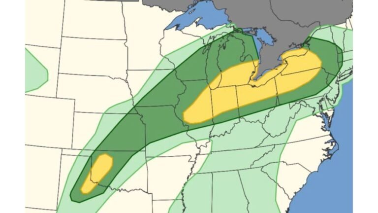
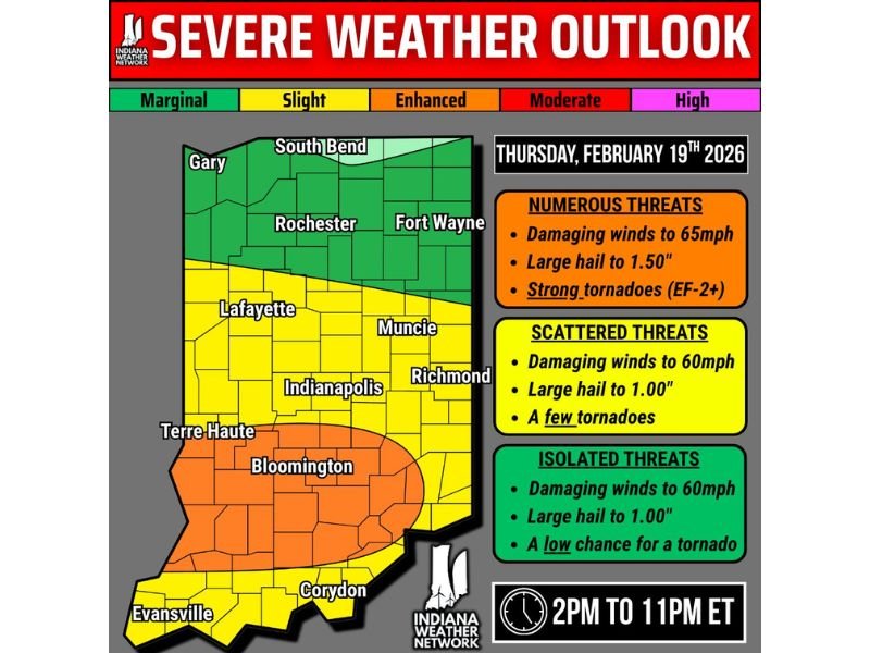
INDIANA — A significant upgrade to today’s severe weather outlook has placed portions of central and southern Indiana under a Level 3 out of 5 “Enhanced Risk,” with forecasters warning that multiple tornadoes — including a few strong EF-2+ tornadoes — are possible between 2 PM and 11 PM ET.
The latest severe weather graphic highlights south-central Indiana as the primary concern, where atmospheric conditions are becoming increasingly favorable for organized, rotating thunderstorms capable of producing damaging winds, large hail, and tornadoes.
Enhanced Risk Zone Centers on Bloomington and Terre Haute
The orange-shaded Level 3 risk area is focused on Bloomington and stretches west toward Terre Haute, covering portions of south-central Indiana.
Within this enhanced corridor, forecasters are warning of:
- Damaging wind gusts up to 60–65 mph
- Large hail up to 1.50 inches in diameter (ping-pong ball size)
- Several tornadoes, some potentially strong (EF-2 or higher)
Meteorologists note that storm fuel (instability) and wind shear are increasing across southern counties. This combination supports the development of organized storms that could rotate and sustain tornado potential through the afternoon and evening.
Level 2 and Level 1 Risks Surround the Core Threat Area
Surrounding the enhanced risk area is a broader Level 2 “Slight Risk” zone, including cities such as Indianapolis, Muncie, Lafayette, and Richmond.
In these areas:
- Damaging winds up to 60 mph are possible
- Hail up to 1.00 inch may occur
- A few tornadoes cannot be ruled out
Farther north, including South Bend, Fort Wayne, Gary, and Rochester, a Level 1 (Marginal Risk) is in place. Isolated severe storms are possible there, but the tornado threat is lower compared to south-central Indiana.
Why Today’s Setup Has Raised Concern
Forecasters emphasize that atmospheric “ingredients” are coming together in a way that supports an all-hazards severe weather event.
Increasing low-level moisture combined with strengthening wind fields has elevated the tornado risk, especially in the orange enhanced zone. Officials caution that if storms organize efficiently, a couple of strong tornadoes could develop.
The most critical timeframe remains:
2 PM through 11 PM Eastern Time
Storms that form within this window may intensify quickly, especially across the enhanced risk area.
Residents Urged to Remain Weather Aware
Meteorologists are urging residents across Indiana — particularly those within the Level 3 zone — to have multiple ways to receive warnings. Tornado warnings can be issued with limited lead time, especially in dynamic setups like today’s.
Safety reminders include:
- Keep wireless emergency alerts enabled on mobile devices
- Monitor trusted weather sources throughout the afternoon
- Identify a safe shelter location in advance
- Do not rely solely on outdoor sirens
While today’s highest threat is centered in Indiana, Cabarrus Weekly continues to monitor severe weather developments nationwide and how similar storm systems may evolve in the coming weeks. Stay weather aware and check back for updates as conditions develop.