Powerful Western U.S. Storm With Arctic Air and Subtropical Jet Interaction Could Send Heavy Rain Into North Carolina as Ridge Rebuilds
NORTH CAROLINA — A complex western U.S. storm system fueled by Arctic air, a strengthening ridge, and a moisture-rich subtropical jet is taking shape, and its eastward evolution could influence rainfall and temperature swings across North Carolina heading into early March.
Western Ridge and Developing Storm Set the Stage
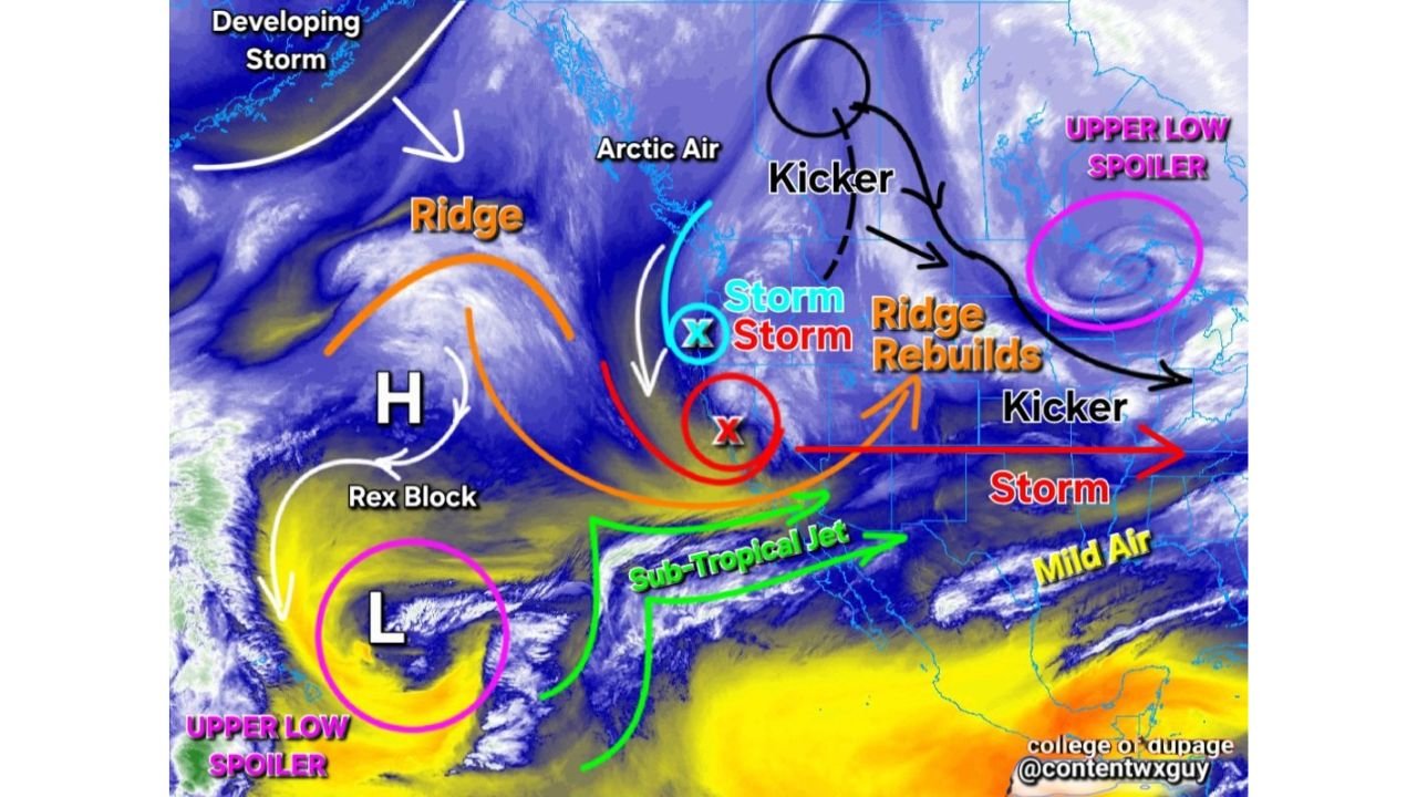
Satellite analysis highlights a strong ridge building along the West Coast, with a developing storm system positioned downstream over the central United States. This ridge is a critical feature, acting as a steering mechanism that helps determine how far east the storm energy progresses.
Beneath the ridge, a pronounced upper-level disturbance — often referred to as a “kicker” — is diving southeast out of western Canada. This feature is interacting with Arctic air spilling southward, enhancing the temperature contrast across the Plains and Midwest.
That contrast is one of the key ingredients needed to generate a robust storm system.
Subtropical Jet Pumps Moisture Toward the East
Another important component visible in the pattern is the subtropical jet stream, arcing from the eastern Pacific across northern Mexico and into the southern United States.
This jet is transporting mild, moisture-laden air eastward. When that moisture interacts with colder air advancing from the north, the result can be a strengthening surface low and expanding precipitation shield.
The imagery also identifies so-called “upper low spoilers” over the Pacific and eastern Canada. These features can either enhance or disrupt storm development depending on timing and positioning. If they align favorably, the central U.S. storm could deepen further before shifting toward the East Coast.
Storm Track and Ridge Rebuild Will Determine North Carolina Impact
As the system progresses, the ridge is expected to rebuild over parts of the eastern United States, which could influence the eventual storm track.
If the ridge holds firm, it may nudge the storm slightly offshore. If it weakens or shifts, a more inland track becomes possible. That difference will determine how much rainfall reaches North Carolina and whether the state sees primarily rain or a brief mix in the mountains.
For Cabarrus County and surrounding communities, the most likely scenario at this stage involves:
Increasing rain chances as the system approaches
Periods of gusty winds with frontal passage
Noticeable temperature swings between mild and cooler air
Arctic Air Adds Energy to the System
The presence of Arctic air feeding into the northern side of the storm adds additional energy to the atmospheric setup. When cold air undercuts milder subtropical moisture, lift intensifies, helping storms strengthen more efficiently.
While the heaviest impacts initially focus across the central United States, this injection of colder air supports the idea of a well-organized system capable of maintaining strength as it tracks eastward.
That raises the likelihood of a more active stretch for the Southeast rather than a weak, fading disturbance.
What Cabarrus County Should Watch
The key uncertainties revolve around timing and exact storm path, but the pattern strongly favors unsettled conditions moving into the Carolinas.
Residents should prepare for:
Above-normal rainfall potential
Intermittent thunderstorm chances
Short-lived cool downs behind passing fronts
There is no clear indication of a prolonged winter outbreak for central North Carolina, but the clash of air masses suggests active weather rather than calm, high-pressure dominance.
As this system continues to organize, forecast clarity will improve over the coming days.
If you notice changing conditions or have rainfall totals to report in your area, share your updates and stay connected with the latest forecasts at CabarrusWeekly.com.