Presidents’ Day Weekend Snowstorm Talk Builds Along the East Coast, but Forecast Uncertainty Remains Exceptionally High
EASTERN UNITED STATES — As early chatter grows around a potential East Coast snowstorm during Presidents’ Day Weekend, meteorologists are urging caution, noting that the large-scale pattern is still far too uncertain to determine whether a storm will even develop, let alone where it might track or produce snow.
What Meteorologists Are Confident About So Far
Forecast guidance consistently shows a southeastern Canada trough positioned beneath a Labrador ridge, a configuration that promotes antecedent confluence across eastern Canada and the northern United States. This type of setup can be supportive of winter storms by helping establish surface-level pressure patterns favorable for development along the East Coast.
However, despite the favorable upper-air alignment, the antecedent air mass does not currently appear particularly cold, which complicates snowfall potential even if a storm were to form.
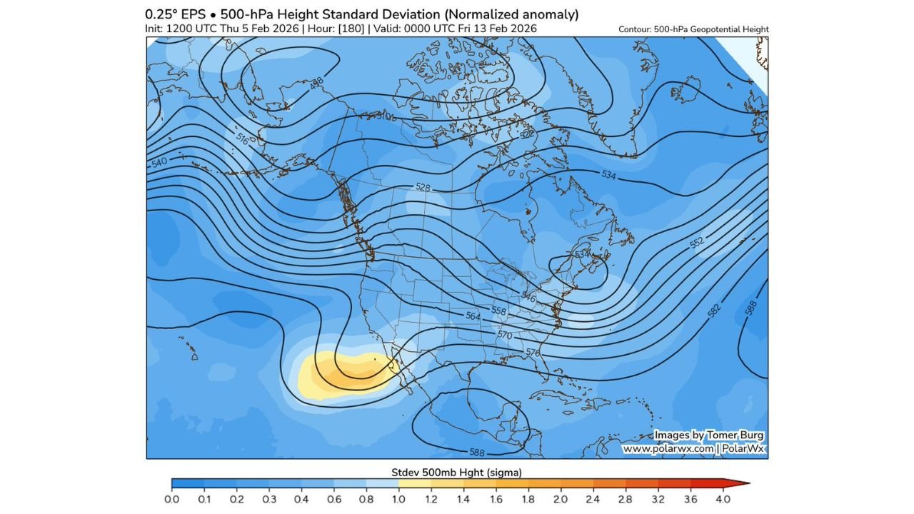
The Biggest Unknown Lies Over the Southwestern United States
The most critical uncertainty centers on the evolution of a trough over the southwestern United States. Ensemble guidance reveals exceptionally large spread in this feature, with variability running nearly 1.6 times greater than normal climatological levels for this time of year.
This matters because how this southwestern trough evolves will determine everything downstream—including whether energy ejects eastward, how quickly it does so, and whether it can phase with northern-stream energy in time to support a coastal storm.
Why Ensemble Spread Is a Red Flag for Early Forecasts
The unusually high ensemble spread highlighted in current data is a clear signal that forecast confidence is very low. When spread reaches this magnitude, it indicates that models disagree not just on storm details, but on whether a storm exists at all.
In these situations, even small shifts in upper-level energy can mean the difference between a major East Coast winter storm, a rain event, or no organized system whatsoever.
Timing and Location Are Impossible to Pin Down Right Now
Until the uncertainty tied to the southwestern trough narrows, it is scientifically impossible to know where or if a storm will occur along the East Coast during the holiday weekend. Any specific claims about snowfall totals, storm tracks, or impacted cities at this range are pure speculation, not forecast certainty.
Meteorologists emphasize that meaningful clarity will only come once models converge on a more consistent solution for the large-scale pattern.
What Happens Next in the Forecast Process
Over the coming days, forecasters will be watching for reduced ensemble spread and improved agreement on the western U.S. trough. Once that happens, confidence in downstream impacts across the East Coast can increase rapidly—but until then, restraint is essential.
Residents along the East Coast are encouraged to stay informed, but not alarmed. Share your thoughts and follow ongoing, evidence-based weather coverage at CabarrusWeekly.com as meteorologists continue tracking this evolving pattern.